
Sedimentary rocks are types of rock that are formed by the accumulation or deposition of mineral or organic particles at Earth's surface, followed by cementation. Sedimentation is the collective name for processes that cause these particles to settle in place. The particles that form a sedimentary rock are called sediment, and may be composed of geological detritus (minerals) or biological detritus. The geological detritus originated from weathering and erosion of existing rocks, or from the solidification of molten lava blobs erupted by volcanoes. The geological detritus is transported to the place of deposition by water, wind, ice or mass movement, which are called agents of denudation. Biological detritus was formed by bodies and parts of dead aquatic organisms, as well as their fecal mass, suspended in water and slowly piling up on the floor of water bodies. Sedimentation may also occur as dissolved minerals precipitate from water solution.

Sedimentary basins are region-scale depressions of the Earth's crust where subsidence has occurred and a thick sequence of sediments have accumulated to form a large three-dimensional body of sedimentary rock. They form when long-term subsidence creates a regional depression that provides accommodation space for accumulation of sediments. Over millions or tens or hundreds of millions of years the deposition of sediment, primarily gravity-driven transportation of water-borne eroded material, acts to fill the depression. As the sediments are buried, they are subject to increasing pressure and begin the processes of compaction and lithification that transform them into sedimentary rock.
This is a list of all articles related to geology that cannot be readily placed on the following subtopic pages:

A craton is an old and stable part of the continental lithosphere, which consists of Earth's two topmost layers, the crust and the uppermost mantle. Having often survived cycles of merging and rifting of continents, cratons are generally found in the interiors of tectonic plates; the exceptions occur where geologically recent rifting events have separated cratons and created passive margins along their edges. Cratons are characteristically composed of ancient crystalline basement rock, which may be covered by younger sedimentary rock. They have a thick crust and deep lithospheric roots that extend as much as several hundred kilometres into Earth's mantle.
Sequence stratigraphy is a branch of geology, specifically a branch of stratigraphy, that attempts to discern and understand historic geology through time by subdividing and linking sedimentary deposits into unconformity bounded units on a variety of scales. The essence of the method is mapping of strata based on identification of surfaces which are assumed to represent time lines, thereby placing stratigraphy in chronostratigraphic framework allowing understanding of the evolution of the earth's surface in a particular region through time. Sequence stratigraphy is a useful alternative to a purely lithostratigraphic approach, which emphasizes solely based on the compositional similarity of the lithology of rock units rather than time significance. Unconformities are particularly important in understanding geologic history because they represent erosional surfaces where there is a clear gap in the record. Conversely within a sequence the geologic record should be relatively continuous and complete record that is genetically related.

The Acadian orogeny is a long-lasting mountain building event which began in the Middle Devonian, reaching a climax in the early Late Devonian. It was active for approximately 50 million years, beginning roughly around 375 million years ago, with deformational, plutonic, and metamorphic events extending into the Early Mississippian. The Acadian orogeny is the third of the four orogenies that formed the Appalachian orogen and subsequent basin. The preceding orogenies consisted of the Potomac and Taconic orogeny, which followed a rift/drift stage in the Late Neoproterozoic. The Acadian orogeny involved the collision of a series of Avalonian continental fragments with the Laurasian continent. Geographically, the Acadian orogeny extended from the Canadian Maritime provinces migrating in a southwesterly direction toward Alabama. However, the Northern Appalachian region, from New England northeastward into Gaspé region of Canada, was the most greatly affected region by the collision.
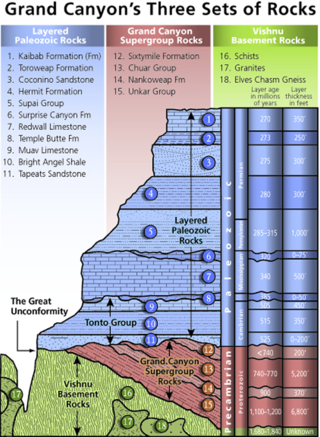
Of the many unconformities (gaps) observed in geological strata, the term Great Unconformity is frequently applied to either the unconformity observed by James Hutton in 1787 at Siccar Point in Scotland, or that observed by John Wesley Powell in the Grand Canyon in 1869. Both instances are exceptional examples of where the contacts between sedimentary strata and either sedimentary or crystalline strata of greatly different ages, origins, and structure represent periods of geologic time sufficiently long to raise great mountains and then erode them away.

A marine transgression is a geologic event during which sea level rises relative to the land and the shoreline moves toward higher ground, which results in flooding. Transgressions can be caused by the land sinking or by the ocean basins filling with water or decreasing in capacity. Transgressions and regressions may be caused by tectonic events such as orogenies, severe climate change such as ice ages or isostatic adjustments following removal of ice or sediment load.
The Sauk sequence was the earliest of the six cratonic sequences that have occurred during the Phanerozoic in North America. It was followed by the Tippecanoe, Kaskaskia, Absaroka, Zuñi, and Tejas sequences.
The Tippecanoe sequence was the cratonic sequence or the marine transgression following the Sauk sequence; it extended from roughly the Middle Ordovician to the Early Devonian. The Tippecanoe is bound by two Unconformities, at the base by the Knox Unconformity, and at its top the Wallbridge Unconformity.
The Absaroka sequence was a cratonic sequence that extended from the end of the Mississippian through the Permian periods. There is an unconformity between the Absaroka and the lower Kaskaskia sequence. This unconformity divides the Carboniferous into the Mississippian and Pennsylvanian periods in North America.
The Zuñi sequence was the major cratonic sequence after the Absaroka sequence that began in the latest Jurassic, peaked in the late Cretaceous, and ended by the start of the following Paleocene. Though it was not the final major transgression, it was the last complete sequence to cover the North American craton; the following Tejas sequence was much less extensive.

The North China Craton is a continental crustal block with one of Earth's most complete and complex records of igneous, sedimentary and metamorphic processes. It is located in northeast China, Inner Mongolia, the Yellow Sea, and North Korea. The term craton designates this as a piece of continent that is stable, buoyant and rigid. Basic properties of the cratonic crust include being thick, relatively cold when compared to other regions, and low density. The North China Craton is an ancient craton, which experienced a long period of stability and fitted the definition of a craton well. However, the North China Craton later experienced destruction of some of its deeper parts (decratonization), which means that this piece of continent is no longer as stable.
Stratigraphic cycles refer to the transgressive and regressive sequences bounded by unconformities in the stratigraphic record on the cratons. These cycles represent a large scale eustasy cycle since the Cambrian period with further sub-divisions of those units.
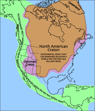
Laurentia or the North American Craton is a large continental craton that forms the ancient geological core of North America. Many times in its past, Laurentia has been a separate continent, as it is now in the form of North America, although originally it also included the cratonic areas of Greenland and also the northwestern part of Scotland, known as the Hebridean Terrane. During other times in its past, Laurentia has been part of larger continents and supercontinents and itself consists of many smaller terranes assembled on a network of Early Proterozoic orogenic belts. Small microcontinents and oceanic islands collided with and sutured onto the ever-growing Laurentia, and together formed the stable Precambrian craton seen today.
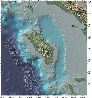
The Nias Basin is a forearc basin located off the western coast of Sumatra, Indonesia, in the Indian Ocean. The name is derived from the island that bounds its western edge, the island of Nias. The Nias Basin, the island of Nias, and the offshore, submarine accretionary complex, together form a Forearc region on the Sunda Plate/Indo-Australian Plate collisional/subduction boundary. The Forearc region is the area between an oceanic trench and its associated volcanic arc. The oceanic trench associated with the Nias Basin is the Sunda Trench, and the associated volcanic arc is the Sunda Arc.

The North Sea is part of the Atlantic Ocean in northern Europe. It is located between Norway and Denmark in the east, Scotland and England in the west, Germany, the Netherlands, Belgium and France in the south.
One of the major depositional strata in the Himalaya is the Lesser Himalayan Strata from the Paleozoic to Mesozoic eras. It had a quite different marine succession during the Paleozoic, as most parts of it are sparsely fossiliferous or even devoid of any well-defined fossils. Moreover, it consists of many varied lithofacies, making correlation work more difficult. This article describes the major formations of the Paleozoic – Mesozoic Lesser Himalayan Strata, including the Tal Formation, Gondwana Strata, Singtali Formation and Subathu Formation.
Laurence L. Sloss was an American geologist. He taught geology at Northwestern University from 1947 until his retirement in 1981.

The Parnaíba Basin is a large cratonic sedimentary basin located in the North and Northeast portion of Brazil. About 50% of its areal distribution occurs in the state of Maranhão, and the other 50% occurring in the state of Pará, Piauí, Tocantins, and Ceará. It is one of the largest Paleozoic basins in the South American Platform. The basin has a roughly ellipsoidal shape, occupies over 600,000 km2, and is composed of ~3.4 km of mainly Paleozoic sedimentary rock that overlies localized rifts.
