
The Global Positioning System (GPS), originally Navstar GPS, is a satellite-based radionavigation system owned by the United States government and operated by the United States Space Force. It is one of the global navigation satellite systems (GNSS) that provides geolocation and time information to a GPS receiver anywhere on or near the Earth where there is an unobstructed line of sight to four or more GPS satellites. Obstacles such as mountains and buildings block the relatively weak GPS signals.

Navigation is a field of study that focuses on the process of monitoring and controlling the movement of a craft or vehicle from one place to another. The field of navigation includes four general categories: land navigation, marine navigation, aeronautic navigation, and space navigation.

MISTRAM was a high-resolution tracking system used by the United States Air Force to provide highly detailed trajectory analysis of rocket launches.
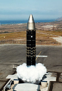
The LGM-118 Peacekeeper, originally known as the MX for "Missile, Experimental", was a MIRV-capable intercontinental ballistic missile (ICBM) produced and deployed by the United States from 1985 to 2005. The missile could carry up to 12 Mk.21 reentry vehicles, although treaty-limited to 10, each armed with a 300-kiloton W87 warhead. Initially, 100 MX ICBMs were planned to be built and deployed, but budgetary concerns eliminated the final procurement and only 50 entered service. Disarmament treaties signed after the Peacekeeper's development concluded in its eventual withdrawal from service in 2005.
A guidance system is a virtual or physical device, or a group of devices implementing a controlling the movement of a ship, aircraft, missile, rocket, satellite, or any other moving object. Guidance is the process of calculating the changes in position, velocity, altitude, and/or rotation rates of a moving object required to follow a certain trajectory and/or altitude profile based on information about the object's state of motion.
Semi-active radar homing (SARH) is a common type of missile guidance system, perhaps the most common type for longer-range air-to-air and surface-to-air missile systems. The name refers to the fact that the missile itself is only a passive detector of a radar signal – provided by an external (“offboard”) source — as it reflects off the target(in contrast to active radar homing, which uses an active radar: transceiver). Semi-active missile systems use bistatic continuous-wave radar.

Missile guidance refers to a variety of methods of guiding a missile or a guided bomb to its intended target. The missile's target accuracy is a critical factor for its effectiveness. Guidance systems improve missile accuracy by improving its Probability of Guidance (Pg).

Real-time kinematic (RTK) positioning is a satellite navigation technique used to enhance the precision of position data derived from satellite-based positioning systems such as GPS, GLONASS, Galileo, NavIC and BeiDou. It uses measurements of the phase of the signal's carrier wave in addition to the information content of the signal and relies on a single reference station or interpolated virtual station to provide real-time corrections, providing up to centimetre-level accuracy. With reference to GPS in particular, the system is commonly referred to as carrier-phase enhancement, or CPGPS. It has applications in land survey, hydrographic survey, and in unmanned aerial vehicle navigation.
The Raduga Kh-20 was an air launched cruise missile armed with a thermonuclear warhead which was developed by the Soviet Union during the Cold War. The Kh-20 was designed to be air-launched.
Terrain Contour Matching, or TERCOM, is a navigation system used primarily by cruise missiles. It uses a pre-recorded contour map of the terrain that is compared with measurements made during flight by an on-board radar altimeter. A TERCOM system considerably increases the accuracy of a missile compared with inertial navigation systems (INS). The increased accuracy allows a TERCOM-equipped missile to fly closer to obstacles and generally lower altitudes, making it harder to detect by ground radar.
A positioning system is a mechanism for determining the position of an object in space. Technologies for this task exist ranging from worldwide coverage with meter accuracy to workspace coverage with sub-millimetre accuracy.

The Weishi family of multiple rocket launcher systems were mainly developed by Sichuan Aerospace Industry Corporation in Chengdu, China. The systems include the 302 mm (11.9 in) WS-1, the improved 302 mm (11.9 in) WS-1B, the 122 mm (4.8 in) WS-1E, the 400 mm (16 in) WS-2, as well as many other models. The WS-1 series weapon system did not enter PLA service and has order from Thailand. The WS-2 may finally see PLA service in the future. It's worth noticing that although sharing the same name, there are other developers for different models of Weishi series multiple rocket launchers (MRL) other than the primary developer SCAIC.

The D37D Minuteman III flight computer was initially supplied with the LGM-30G missile, as part of the NS-20 navigation system. The NS-20 D37D flight computer is a miniaturized general purpose digital computer. The new NS-50 missile guidance computer (MGC) is built around a 16-bit high-speed microprocessor chip set. They are both designed to solve real-time positional error problems under the adverse conditions encountered in airborne weapon systems. They accept and process data and generate steering signals with sufficient accuracy and speed to meet the requirements of the inertial guidance and flight control systems of the Minuteman ICBMs.
An indoor positioning system (IPS) is a network of devices used to locate people or objects where GPS and other satellite technologies lack precision or fail entirely, such as inside multistory buildings, airports, alleys, parking garages, and underground locations.
A PIGA is a type of accelerometer that can measure acceleration and simultaneously integrates this acceleration against time to produce a speed measure as well. The PIGA's main use is in Inertial Navigation Systems (INS) for guidance of aircraft and most particularly for ballistic missile guidance. It is valued for its extremely high sensitivity and accuracy in conjunction with operation over a wide acceleration range. The PIGA is still considered the premier instrument for strategic grade missile guidance, though systems based on MEMS technology are attractive for lower performance requirements.

A long baseline (LBL) acoustic positioning system is one of three broad classes of underwater acoustic positioning systems that are used to track underwater vehicles and divers. The other two classes are ultra short baseline systems (USBL) and short baseline systems (SBL). LBL systems are unique in that they use networks of sea-floor mounted baseline transponders as reference points for navigation. These are generally deployed around the perimeter of a work site. The LBL technique results in very high positioning accuracy and position stability that is independent of water depth. It is generally better than 1-meter and can reach a few centimeters accuracy. LBL systems are generally employed for precision underwater survey work where the accuracy or position stability of ship-based positioning systems does not suffice.

An inertial navigation system (INS) is a navigation device that uses a computer, motion sensors (accelerometers) and rotation sensors (gyroscopes) to continuously calculate by dead reckoning the position, the orientation, and the velocity of a moving object without the need for external references. Often the inertial sensors are supplemented by a barometric altimeter and occasionally by magnetic sensors (magnetometers) and/or speed measuring devices. INSs are used on mobile robots and on vehicles such as ships, aircraft, submarines, guided missiles, and spacecraft. Other terms used to refer to inertial navigation systems or closely related devices include inertial guidance system, inertial instrument, inertial measurement unit (IMU) and many other variations. Older INS systems generally used an inertial platform as their mounting point to the vehicle and the terms are sometimes considered synonymous.
The YJ-22 is a LACM development of the anti-ship C-802 with a 400 km range, and possible Satellite guidance/terrain mapping guidance currently said to be under development, Initial Operational Capability was expected after 2005. This 135-kilometer range system would be the first Chinese cruise missile to incorporate BeiDou Navigation Satellite System-assisted navigation. Satellite-aided guidance could be augmented by terrain contour matching TERCOM guidance. Some sources believe BeiDou-aided navigation could result in cruise missiles like the YJ-22 to achieve accuracies of up to 10 meters.

An inertial measurement unit (IMU) is an electronic device that measures and reports a body's specific force, angular rate, and sometimes the orientation of the body, using a combination of accelerometers, gyroscopes, and sometimes magnetometers. IMUs are typically used to maneuver aircraft, including unmanned aerial vehicles (UAVs), among many others, and spacecraft, including satellites and landers. Recent developments allow for the production of IMU-enabled GPS devices. An IMU allows a GPS receiver to work when GPS-signals are unavailable, such as in tunnels, inside buildings, or when electronic interference is present. A wireless IMU is known as a WIMU.