See also
Wikimedia Commons has media related to Navigation systems .
A navigation system is a computing system that aids in navigation. Navigation systems may be entirely on board the vehicle or vessel that the system is controlling (for example, on the ship's bridge) or located elsewhere, making use of radio or other signal transmission to control the vehicle or vessel. In some cases, a combination of these methods is used.
Navigation systems may be capable of one or more of:
The first in-car navigation system available to consumers in 1985 was called Etak Navigation. [3] The company, Etak, was led by engineer Stan Honey and incubated by Nolan Bushnell's Catalyst Technologies in Silicon Valley. [4] Etak held a number of patents and produced digitized maps for the navigation system. [3] The maps were streamed to the navigation system from special tape cassettes. The early digitized maps turned out to be more valuable than the navigation system. [4] The car icon used in Etak Navigation display was a vector-based graphic based on Atari, Inc.'s Asteroids spaceship. [4]

Navigation is a field of study that focuses on the process of monitoring and controlling the movement of a craft or vehicle from one place to another. The field of navigation includes four general categories: land navigation, marine navigation, aeronautic navigation, and space navigation.

Nolan Kay Bushnell is an American businessman and electrical engineer. He established Atari, Inc. and the Chuck E. Cheese's Pizza Time Theatre chain. He has been inducted into the Video Game Hall of Fame and the Consumer Electronics Association Hall of Fame, received the BAFTA Fellowship and the Nations Restaurant News "Innovator of the Year" award, and was named one of Newsweek's "50 Men Who Changed America". He has started more than 20 companies and is one of the founding fathers of the video game industry. He is on the board of Anti-Aging Games. In 2012, he founded an educational software company called Brainrush, that is using video game technology in educational software.

In navigation, dead reckoning is the process of calculating the current position of a moving object by using a previously determined position, or fix, and incorporating estimates of speed, heading, and elapsed time. The corresponding term in biology, to describe the processes by which animals update their estimates of position or heading, is path integration.
A guidance system is a virtual or physical device, or a group of devices implementing a controlling the movement of a ship, aircraft, missile, rocket, satellite, or any other moving object. Guidance is the process of calculating the changes in position, velocity, altitude, and/or rotation rates of a moving object required to follow a certain trajectory and/or altitude profile based on information about the object's state of motion.
Missile guidance refers to a variety of methods of guiding a missile or a guided bomb to its intended target. The missile's target accuracy is a critical factor for its effectiveness. Guidance systems improve missile accuracy by improving its Probability of Guidance (Pg).

Draper Laboratory is an American non-profit research and development organization, headquartered in Cambridge, Massachusetts; its official name is The Charles Stark Draper Laboratory, Inc. The laboratory specializes in the design, development, and deployment of advanced technology solutions to problems in national security, space exploration, health care and energy.

An automotive navigation system is part of the automobile controls or a third party add-on used to find direction in an automobile. It typically uses a satellite navigation device to get its position data which is then correlated to a position on a road. When directions are needed routing can be calculated. On the fly traffic information can be used to adjust the route.
Navteq Corporation was an American Chicago-based provider of geographic information system (GIS) data and a major provider of base electronic navigable maps. The company was acquired by Nokia in 2007–2008, and fully merged into Nokia in 2011 to form part of the Here business unit. The unit was subsequently sold to a consortium of German auto makers in 2016.
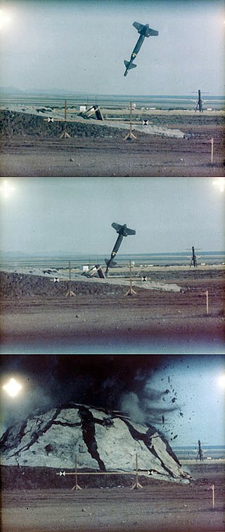
Terrain contour matching, or TERCOM, is a navigation system used primarily by cruise missiles. It uses a contour map of the terrain that is compared with measurements made during flight by an on-board radar altimeter. A TERCOM system considerably increases the accuracy of a missile compared with inertial navigation systems (INS). The increased accuracy allows a TERCOM-equipped missile to fly closer to obstacles and at generally lower altitudes, making it harder to detect by ground radar.
A positioning system is a system for determining the position of an object in space. Positioning system technologies exist ranging from interplanetary coverage with meter accuracy to workspace and laboratory coverage with sub-millimeter accuracy. A major subclass is made of geopositioning systems, used for determining an object's position with respect to Earth, i.e., its geographical position; one of the most well-known and commonly used geopositioning systems is the Global Positioning System (GPS) and similar global navigation satellite systems (GNSS).
The Catalyst Technologies Venture Capital Group was one of the first technology company incubators. It was founded in 1981 in Sunnyvale, California by Atari co-founder Nolan Bushnell and received much assistance from fellow Atari luminary, Al Alcorn. The term Catalyst Group may refer to both the companies spawned by the Group and the people involved.

An indoor positioning system (IPS) is a network of devices used to locate people or objects where GPS and other satellite technologies lack precision or fail entirely, such as inside multistory buildings, airports, alleys, parking garages, and underground locations.
Etak, Inc. was an independent US-based vendor of automotive navigation system equipment, digital maps, and mapping software. It was founded in 1983. Competitor Navteq was founded in 1985.

Robot localization denotes the robot's ability to establish its own position and orientation within the frame of reference. Path planning is effectively an extension of localization, in that it requires the determination of the robot's current position and a position of a goal location, both within the same frame of reference or coordinates. Map building can be in the shape of a metric map or any notation describing locations in the robot frame of reference.
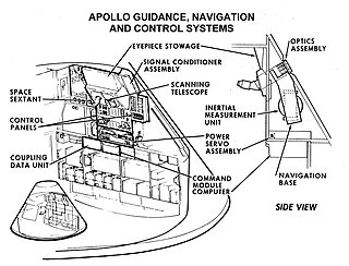
Guidance, navigation and control is a branch of engineering dealing with the design of systems to control the movement of vehicles, especially, automobiles, ships, aircraft, and spacecraft. In many cases these functions can be performed by trained humans. However, because of the speed of, for example, a rocket's dynamics, human reaction time is too slow to control this movement. Therefore, systems—now almost exclusively digital electronic—are used for such control. Even in cases where humans can perform these functions, it is often the case that GNC systems provide benefits such as alleviating operator work load, smoothing turbulence, fuel savings, etc. In addition, sophisticated applications of GNC enable automatic or remote control.

A satellite navigation device, satnav device or satellite navigation receiver is a user equipment that uses one or more of several global navigation satellite systems (GNSS) to calculate the device's geographical position and provide navigational advice. Depending on the software used, the satnav device may display the position on a map, as geographic coordinates, or may offer routing directions.
An underwater acoustic positioning system is a system for the tracking and navigation of underwater vehicles or divers by means of acoustic distance and/or direction measurements, and subsequent position triangulation. Underwater acoustic positioning systems are commonly used in a wide variety of underwater work, including oil and gas exploration, ocean sciences, salvage operations, marine archaeology, law enforcement and military activities.

An inertial navigation system is a navigation device that uses motion sensors (accelerometers), rotation sensors (gyroscopes) and a computer to continuously calculate by dead reckoning the position, the orientation, and the velocity of a moving object without the need for external references. Often the inertial sensors are supplemented by a barometric altimeter and sometimes by magnetic sensors (magnetometers) and/or speed measuring devices. INSs are used on mobile robots and on vehicles such as ships, aircraft, submarines, guided missiles, and spacecraft. Older INS systems generally used an inertial platform as their mounting point to the vehicle and the terms are sometimes considered synonymous.

An inertial measurement unit (IMU) is an electronic device that measures and reports a body's specific force, angular rate, and sometimes the orientation of the body, using a combination of accelerometers, gyroscopes, and sometimes magnetometers. When the magnetometer is included, IMUs are referred to as IMMUs.

Geopositioning is the process of determining or estimating the geographic position of an object or a person.