Computer vision tasks include methods for acquiring, processing, analyzing, and understanding digital images, and extraction of high-dimensional data from the real world in order to produce numerical or symbolic information, e.g. in the form of decisions. "Understanding" in this context signifies the transformation of visual images into descriptions of the world that make sense to thought processes and can elicit appropriate action. This image understanding can be seen as the disentangling of symbolic information from image data using models constructed with the aid of geometry, physics, statistics, and learning theory.

In navigation, dead reckoning is the process of calculating the current position of a moving object by using a previously determined position, or fix, and incorporating estimates of speed, heading, and elapsed time. The corresponding term in biology, to describe the processes by which animals update their estimates of position or heading, is path integration.

Avinash C. Kak is a professor of Electrical and Computer Engineering at Purdue University who has conducted pioneering research in several areas of information processing. His most noteworthy contributions deal with algorithms, languages, and systems related to networks, robotics, and computer vision. Born in Srinagar, Kashmir, he did his Bachelors in BE at University of Madras and Phd in Indian Institute of Technology Delhi. He joined the faculty of Purdue University in 1971.
Robotic mapping is a discipline related to computer vision and cartography. The goal for an autonomous robot is to be able to construct a map or floor plan and to localize itself and its recharging bases or beacons in it. Robotic mapping is that branch which deals with the study and application of ability to localize itself in a map / plan and sometimes to construct the map or floor plan by the autonomous robot.

Simultaneous localization and mapping (SLAM) is the computational problem of constructing or updating a map of an unknown environment while simultaneously keeping track of an agent's location within it. While this initially appears to be a chicken or the egg problem, there are several algorithms known to solve it in, at least approximately, tractable time for certain environments. Popular approximate solution methods include the particle filter, extended Kalman filter, covariance intersection, and GraphSLAM. SLAM algorithms are based on concepts in computational geometry and computer vision, and are used in robot navigation, robotic mapping and odometry for virtual reality or augmented reality.

Gregory L. Dudek is a Canadian computer scientist specializing in robotics, computer vision, and intelligent systems. He is a chaired professor at McGill University where he has led the Mobile Robotics Lab since the 1990s. He was formerly the director of McGill's school of computer science and before that director of McGill's center for intelligent machines.

A mobile robot is an automatic machine that is capable of locomotion. Mobile robotics is usually considered to be a subfield of robotics and information engineering.
A positioning system is a system for determining the position of an object in space. Positioning system technologies exist ranging from interplanetary coverage with meter accuracy to workspace and laboratory coverage with sub-millimeter accuracy. A major subclass is made of geopositioning systems, used for determining an object's position with respect to Earth, i.e., its geographical position; one of the most well-known and commonly used geopositioning systems is the Global Positioning System (GPS) and similar global navigation satellite systems (GNSS).

An indoor positioning system (IPS) is a network of devices used to locate people or objects where GPS and other satellite technologies lack precision or fail entirely, such as inside multistory buildings, airports, alleys, parking garages, and underground locations.
Wi-Fi positioning system is a geolocation system that uses the characteristics of nearby Wi‑Fi access points to discover where a device is located.

In robotics and computer vision, visual odometry is the process of determining the position and orientation of a robot by analyzing the associated camera images. It has been used in a wide variety of robotic applications, such as on the Mars Exploration Rovers.
The Guidance, Control and Decision Systems Laboratory (GCDSL) is situated in the Department of Aerospace Engineering at the Indian Institute of Science in Bangalore, India. The Mobile Robotics Laboratory (MRL) is its experimental division. They are headed by Dr. Debasish Ghose, Full Professor.

The Mobile Robot Programming Toolkit (MRPT) is a cross-platform software C++ library for helping robotics researchers design and implement algorithms related to simultaneous localization and mapping (SLAM), computer vision, and motion planning. Different research groups have employed MRPT to implement projects reported in some of the major robotics journals and conferences.

An inertial navigation system is a navigation device that uses motion sensors (accelerometers), rotation sensors (gyroscopes) and a computer to continuously calculate by dead reckoning the position, the orientation, and the velocity of a moving object without the need for external references. Often the inertial sensors are supplemented by a barometric altimeter and sometimes by magnetic sensors (magnetometers) and/or speed measuring devices. INSs are used on mobile robots and on vehicles such as ships, aircraft, submarines, guided missiles, and spacecraft. Older INS systems generally used an inertial platform as their mounting point to the vehicle and the terms are sometimes considered synonymous.

An inertial measurement unit (IMU) is an electronic device that measures and reports a body's specific force, angular rate, and sometimes the orientation of the body, using a combination of accelerometers, gyroscopes, and sometimes magnetometers. When the magnetometer is included, IMUs are referred to as IMMUs.
Air-Cobot (Aircraft Inspection enhanced by smaRt & Collaborative rOBOT) is a French research and development project of a wheeled collaborative mobile robot able to inspect aircraft during maintenance operations. This multi-partner project involves research laboratories and industry. Research around this prototype was developed in three domains: autonomous navigation, human-robot collaboration and nondestructive testing.
Intrinsic localization is a method used in mobile laser scanning to recover the trajectory of the scanner, after, or during the measurement. Specifically, it is a way to recover the spatial coordinates and the rotation of the scanner without the use of any other sensors, i.e, extrinsic information. To function in practice, intrinsic localization relies on two things. First, a priori knowledge of the scanning instruments, and second, on sensor data overlap employing simultaneous localization and mapping (SLAM) methods. The term was coined in.
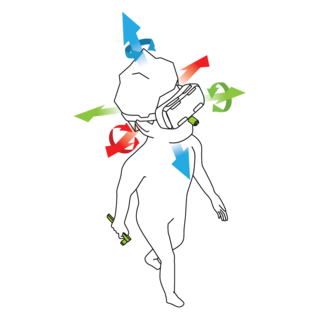
In virtual reality (VR) and augmented reality (AR), a pose tracking system detects the precise pose of head-mounted displays, controllers, other objects or body parts within Euclidean space. Pose tracking is often referred to as 6DOF tracking, for the six degrees of freedom in which the pose is often tracked.

Margarita Chli is an assistant professor and leader of the Vision for Robotics Lab at ETH Zürich in Switzerland. Chli is a leader in the field of computer vision and robotics and was on the team of researchers to develop the first fully autonomous helicopter with onboard localization and mapping. Chli is also the Vice Director of the Institute of Robotics and Intelligent Systems and an Honorary Fellow of the University of Edinburgh in the United Kingdom. Her research currently focuses on developing visual perception and intelligence in flying autonomous robotic systems.

Geopositioning is the process of determining or estimating the geographic position of an object or a person.