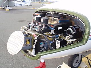
Avionics are the electronic systems used on aircraft. Avionic systems include communications, navigation, the display and management of multiple systems, and the hundreds of systems that are fitted to aircraft to perform individual functions. These can be as simple as a searchlight for a police helicopter or as complicated as the tactical system for an airborne early warning platform.

Navigation is a field of study that focuses on the process of monitoring and controlling the movement of a craft or vehicle from one place to another. The field of navigation includes four general categories: land navigation, marine navigation, aeronautic navigation, and space navigation.

In telecommunications, a transponder is a device that, upon receiving a signal, emits a different signal in response. The term is a blend of transmitter and responder.
Electromagnetic warfare or electronic warfare (EW) is warfare involving the use of the electromagnetic spectrum or directed energy to control the spectrum, attack an enemy, or impede enemy operations. The purpose of electromagnetic warfare is to deny the opponent the advantage of—and ensure friendly unimpeded access to—the EM spectrum. Electromagnetic warfare can be applied from air, sea, land, or space by crewed and uncrewed systems, and can target communication, radar, or other military and civilian assets.
Localization or localisation may refer to:

Radio navigation or radionavigation is the application of radio waves to determine a position of an object on the Earth, either the vessel or an obstruction. Like radiolocation, it is a type of radiodetermination.
The basic principles of air navigation are identical to general navigation, which includes the process of planning, recording, and controlling the movement of a craft from one place to another.

A navigator is the person on board a ship or aircraft responsible for its navigation. The navigator's primary responsibility is to be aware of ship or aircraft position at all times. Responsibilities include planning the journey, advising the ship's captain or aircraft commander of estimated timing to destinations while en route, and ensuring hazards are avoided. The navigator is in charge of maintaining the aircraft or ship's nautical charts, nautical publications, and navigational equipment, and they generally have responsibility for meteorological equipment and communications. With the advent of satellite navigation, the effort required to accurately determine one's position has decreased by orders of magnitude, so the entire field has experienced a revolutionary transition since the 1990s with traditional navigation tasks, like performing celestial navigation, being used less frequently. Using multiple independent position fix methods without solely relying on electronic systems subject to failure helps the navigator detect errors. Professional mariners are still proficient in traditional piloting and celestial navigation.

Satellite geodesy is geodesy by means of artificial satellites—the measurement of the form and dimensions of Earth, the location of objects on its surface and the figure of the Earth's gravity field by means of artificial satellite techniques. It belongs to the broader field of space geodesy. Traditional astronomical geodesy is not commonly considered a part of satellite geodesy, although there is considerable overlap between the techniques.

A satellite navigation or satnav system is a system that uses satellites to provide autonomous geopositioning. A satellite navigation system with global coverage is termed global navigation satellite system (GNSS). As of 2024, four global systems are operational: the United States's Global Positioning System (GPS), Russia's Global Navigation Satellite System (GLONASS), China's BeiDou Navigation Satellite System (BDS), and the European Union's Galileo.

As defined by FS-1037C and ITU Radio Regulations, radiodetermination is:
the determination of the position, velocity or other characteristics of an object, or the obtaining of information relating to these parameters, by means of the propagation properties of radio waves
Radiolocation, also known as radiolocating or radiopositioning, is the process of finding the location of something through the use of radio waves. It generally refers to passive, particularly radar—as well as detecting buried cables, water mains, and other public utilities. It is similar to radionavigation in which one actively seeks its own position; both are types of radiodetermination. Radiolocation is also used in real-time locating systems (RTLS) for tracking valuable assets.
A positioning system is a system for determining the position of an object in space. Positioning system technologies exist ranging from interplanetary coverage with meter accuracy to workspace and laboratory coverage with sub-millimeter accuracy. A major subclass is made of geopositioning systems, used for determining an object's position with respect to Earth, i.e., its geographical position; one of the most well-known and commonly used geopositioning systems is the Global Positioning System (GPS) and similar global navigation satellite systems (GNSS).

Operations Specialist is a United States Navy and United States Coast Guard occupational rating. It is a sea duty-intensive rating in the Navy while most of Coast Guard OS's are at ashore Command Centers.

In navigation, a radio beacon or radiobeacon is a kind of beacon, a device that marks a fixed location and allows direction-finding equipment to find relative bearing. But instead of employing visible light, radio beacons transmit electromagnetic radiation in the radio wave band. They are used for direction-finding systems on ships, aircraft and vehicles.

Submarine navigation underwater requires special skills and technologies not needed by surface ships. The challenges of underwater navigation have become more important as submarines spend more time underwater, travelling greater distances and at higher speed. Military submarines travel underwater in an environment of total darkness with neither windows nor lights. Operating in stealth mode, they cannot use their active sonar systems to ping ahead for underwater hazards such as undersea mountains, drilling rigs or other submarines. Surfacing to obtain navigational fixes is precluded by pervasive anti-submarine warfare detection systems such as radar and satellite surveillance. Antenna masts and antenna-equipped periscopes can be raised to obtain navigational signals but in areas of heavy surveillance, only for a few seconds or minutes; current radar technology can detect even a slender periscope while submarine shadows may be plainly visible from the air.

Radio is the technology of communicating using radio waves. Radio waves are electromagnetic waves of frequency between 3 hertz (Hz) and 300 gigahertz (GHz). They are generated by an electronic device called a transmitter connected to an antenna which radiates oscillating electrical energy, often characterized as a wave. They can be received by other antennas connected to a radio receiver; this is the fundamental principle of radio communication. In addition to communication, radio is used for radar, radio navigation, remote control, remote sensing, and other applications.
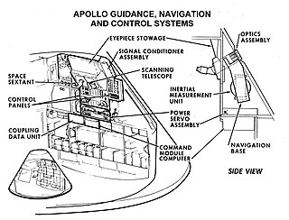
Guidance, navigation and control is a branch of engineering dealing with the design of systems to control the movement of vehicles, especially, automobiles, ships, aircraft, and spacecraft. In many cases these functions can be performed by trained humans. However, because of the speed of, for example, a rocket's dynamics, human reaction time is too slow to control this movement. Therefore, systems—now almost exclusively digital electronic—are used for such control. Even in cases where humans can perform these functions, it is often the case that GNC systems provide benefits such as alleviating operator work load, smoothing turbulence, fuel savings, etc. In addition, sophisticated applications of GNC enable automatic or remote control.

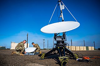
Marine radars are X band or S band radars on ships, used to detect other ships and land hazards, to provide bearing and distance for collision avoidance and navigation at sea. They are electronic navigation instruments that use a rotating antenna to sweep a narrow beam of microwaves around the water surface surrounding the ship to the horizon, detecting targets by microwaves reflected from them, generating a picture of the ship's surroundings on a display screen. The X-Band and S-Band radar has different characteristics and detection capabilities compared with each other. Most merchant ships carry at least one of each type to ensure adequate target detection and response. For example, the S-band operates better in sea clutter and rain than the X-band, however, the X-band has greater definition and accuracy in clear weather.

Geopositioning is the process of determining or estimating the geographic position of an object or a person. Geopositioning yields a set of geographic coordinates in a given map datum. Geographic positions may also be expressed indirectly, as a distance in linear referencing or as a bearing and range from a known landmark. In turn, positions can determine a meaningful location, such as a street address. Geoposition is sometimes referred to as geolocation, and the process of geopositioning may also be described as geo-localization.