
The Global Positioning System (GPS), originally Navstar GPS, is a satellite-based radio navigation system owned by the United States government and operated by the United States Space Force. It is one of the global navigation satellite systems (GNSS) that provide geolocation and time information to a GPS receiver anywhere on or near the Earth where there is an unobstructed line of sight to four or more GPS satellites. It does not require the user to transmit any data, and operates independently of any telephone or Internet reception, though these technologies can enhance the usefulness of the GPS positioning information. It provides critical positioning capabilities to military, civil, and commercial users around the world. Although the United States government created, controls and maintains the GPS system, it is freely accessible to anyone with a GPS receiver.

Telemetry is the in situ collection of measurements or other data at remote points and their automatic transmission to receiving equipment (telecommunication) for monitoring. The word is derived from the Greek roots tele, 'remote', and metron, 'measure'. Systems that need external instructions and data to operate require the counterpart of telemetry: telecommand.

Radio navigation or radionavigation is the application of radio frequencies to determine a position of an object on the Earth, either the vessel or an obstruction. Like radiolocation, it is a type of radiodetermination.

A radio clock or radio-controlled clock (RCC), and often colloquially referred to as an "atomic clock", is a type of quartz clock or watch that is automatically synchronized to a time code transmitted by a radio transmitter connected to a time standard such as an atomic clock. Such a clock may be synchronized to the time sent by a single transmitter, such as many national or regional time transmitters, or may use the multiple transmitters used by satellite navigation systems such as Global Positioning System. Such systems may be used to automatically set clocks or for any purpose where accurate time is needed. Radio clocks may include any feature available for a clock, such as alarm function, display of ambient temperature and humidity, broadcast radio reception, etc.
Measurement and signature intelligence (MASINT) is a technical branch of intelligence gathering, which serves to detect, track, identify or describe the distinctive characteristics (signatures) of fixed or dynamic target sources. This often includes radar intelligence, acoustic intelligence, nuclear intelligence, and chemical and biological intelligence. MASINT is defined as scientific and technical intelligence derived from the analysis of data obtained from sensing instruments for the purpose of identifying any distinctive features associated with the source, emitter or sender, to facilitate the latter's measurement and identification.
In the context of information security, and especially network security, a spoofing attack is a situation in which a person or program successfully identifies as another by falsifying data, to gain an illegitimate advantage.

A cellular network or mobile network is a telecommunications network where the link to and from end nodes is wireless and the network is distributed over land areas called cells, each served by at least one fixed-location transceiver. These base stations provide the cell with the network coverage which can be used for transmission of voice, data, and other types of content. A cell typically uses a different set of frequencies from neighboring cells, to avoid interference and provide guaranteed service quality within each cell.
Broadcast engineering or radio engineering is the field of electrical engineering, and now to some extent computer engineering and information technology, which deals with radio and television broadcasting. Audio engineering and RF engineering are also essential parts of broadcast engineering, being their own subsets of electrical engineering.

Duga was an over-the-horizon radar (OTH) system used in the Soviet Union as part of its early-warning radar network for missile defense. It operated from July 1976 to December 1989. Two operational duga radars were deployed, with one near Chernobyl and Liubech in the Ukrainian SSR, and the other in eastern Siberia.
Passive radar is a class of radar systems that detect and track objects by processing reflections from non-cooperative sources of illumination in the environment, such as commercial broadcast and communications signals. It is a specific case of bistatic radar – passive bistatic radar (PBR) – which is a broad type also including the exploitation of cooperative and non-cooperative radar transmitters.
Radio jamming is the deliberate blocking of or interference with wireless communications. In some cases, jammers work by the transmission of radio signals that disrupt telecommunications by decreasing the signal-to-noise ratio.
Meaconing is the interception and rebroadcast of navigation signals. These signals are rebroadcast on the received frequency, typically with power higher than the original signal, to confuse enemy navigation. Consequently, aircraft or ground stations are given inaccurate bearings.

Radio is the technology of communicating using radio waves. Radio waves are electromagnetic waves of frequency between 3 hertz (Hz) and 300 gigahertz (GHz). They are generated by an electronic device called a transmitter connected to an antenna which radiates the waves. They are received by another antenna connected to a radio receiver. In addition to communication, radio is used for radar, radio navigation, remote control, remote sensing, and other applications.
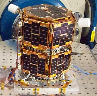
Formation Autonomy Spacecraft with Thrust, Relnav, Attitude and Crosslink is a pair of nanosatellites developed and built by students at The University of Texas at Austin. The project is part of a program sponsored by the Air Force Research Laboratory (AFRL), whose goal is to lead the development of affordable space technology. The FASTRAC mission will specifically investigate technologies that facilitate the operation of multiple satellites in formation. These enabling technologies include relative navigation, cross-link communications, attitude determination, and thrust. Due to the high cost of lifting mass into orbit, there is a strong initiative to miniaturize the overall weight of spacecraft. The utilization of formations of satellites, in place of large single satellites, reduces the risk of single point failure and allows for the use of low-cost hardware.
Real-time locating systems (RTLS), also known as real-time tracking systems, are used to automatically identify and track the location of objects or people in real time, usually within a building or other contained area. Wireless RTLS tags are attached to objects or worn by people, and in most RTLS, fixed reference points receive wireless signals from tags to determine their location. Examples of real-time locating systems include tracking automobiles through an assembly line, locating pallets of merchandise in a warehouse, or finding medical equipment in a hospital.
Rohde & Schwarz GmbH & Co KG is an international electronics group specializing in the fields of electronic test equipment, broadcast & media, cybersecurity, radiomonitoring and radiolocation, and radiocommunication. The company provides also products for the wireless communications, electronics industry, aerospace and defense, homeland security and critical infrastructures.
Satellite geolocation is the process of locating the origin of a signal appearing on a satellite communication channel. Typically, this process is used to mitigate interference on communication satellites. Usually, these interference signals are caused by human error or equipment failure, but can also be caused by deliberate jamming. Identifying the geographical location of an interfering signal informs the mitigation activity.
Mozilla Location Service (MLS) is an open geolocation service which allows devices to find their position by processing their received signals of publicly observable radio transmitters: cellular network antennae, Wi-Fi access points, and Bluetooth beacons. The service is provided by Mozilla since 2013. The service uses Mozilla's open source software project called Ichnaea.

Geopositioning is the process of determining or estimating the geographic position of an object.