Treasury Buildings, Perth

Last updated

Treasury Buildings
AUS Perth, Central Business District, Barrack Street 005.jpg
Treasury Buildings in 2023
Treasury Buildings, Perth
General information
TypeHeritage listed building
Location Perth, Western Australia
Coordinates 31°57′20″S115°51′37″E / 31.9556°S 115.8603°E / -31.9556; 115.8603 (Treasury Buildings)
TypeState Registered Place
Part ofCentral Government Offices (1973)
Reference no. 4275

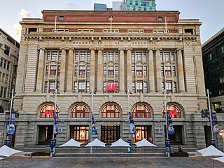
The Treasury Buildings, or Old Treasury Buildings, are part of the Cathedral Square complex situated between Barrack Street and St Georges Terrace in Perth, Western Australia.

In the 1890s the buildings were known as the Government Buildings or Government Offices prior to the Treasury being situated in the building. [1] [2]

The location was considered as significant in that the site of the founding of the city of Perth in 1829 was on the north west corner of the complex. [3]

The buildings contained a range of government departments and office until the late 20th century. [4] [5]

The Premier of Western Australia had offices in the building in the 1920s, and in 1929 protests focused on gathering in front of the buildings were conducted by unemployed. [6] [7]

In the early 21st century, the building was re-developed. [8] [9] It became part of the revitalised Cathedral Square complex, with the name State Buildings. [10]

Notes

  1. "Government Buildings for Perth". Albany Advertiser . Vol. XXIV, no. 3031. Western Australia. 9 March 1912. p. 4. Retrieved 11 November 2017 via National Library of Australia.
  2. Wright, Alfred Robert Linus (1900), Government Offices, St George's Terrace , retrieved 11 November 2017
  3. "The Treasury Buildings, Perth". Sunday Times (Perth) . No. 1636. Western Australia. 2 June 1929. p. 7 (The Sunday Times Special Centenary Supplement). Retrieved 11 November 2017 via National Library of Australia.
  4. Western Australia. Government Photographer (1937), The Treasury Building and St Georges Terrace east from Barrack Street, Perth, June 1937 , retrieved 11 November 2017
  5. Illustrations Ltd; HRRC (1951), Treasury Building, corner of St. George's Terrace and Barrack Street , retrieved 11 November 2017
  6. "Unemployed In Perth". Western Argus . Vol. 35, no. 2042. Western Australia. 23 July 1929. p. 23. Retrieved 11 November 2017 via National Library of Australia.
  7. "Unemployed In Perth". Kalgoorlie Miner . Vol. 34, no. 8983. Western Australia. 24 July 1928. p. 4. Retrieved 11 November 2017 via National Library of Australia.
  8. Treasury buildings : proposals for re-use and new works 2002 Treasury Precinct Perth W.A, UWA, 2002, retrieved 11 November 2017
  9. "Controversy surrounds the redevelopment scheme for the Old Treasury Building, Perth, with the Lord Mayor opposing the project.", Architecture Australia, 95 (5), Architecture Media: 16(1), 1 September 2006, ISSN   0003-8725
  10. http://statebuildings.com/ State Buildings website

Related Research Articles

<span class="mw-page-title-main">East Melbourne</span> Suburb of Melbourne, Victoria, Australia

East Melbourne is an inner-city suburb in Melbourne, Victoria, Australia, 2 km (1.2 mi) east of Melbourne's Central Business District, located within the City of Melbourne local government area. East Melbourne recorded a population of 4,896 at the 2021 census.

<span class="mw-page-title-main">Barracks Arch</span> Part of a former government barracks building in Perth, Western Australia

The Barracks Arch is located on the corner of Malcolm and Elder Streets, at the western end of St Georges Terrace in Perth, Western Australia.

<span class="mw-page-title-main">Government House, Perth</span> Government office in Perth, Western Australia

Government House is the official residence of the governor of Western Australia, situated in the central business district of Perth, the state capital. It was built between 1859 and 1864, in the Jacobean Revival style.

<span class="mw-page-title-main">Barrack Street</span> Street in CBD of Perth, Western Australia

Barrack Street is one of two major cross-streets in the central business district of Perth, Western Australia. Together with St Georges Terrace, Wellington Street and William Street it defines the boundary of the main shopping precinct of the central city.

<span class="mw-page-title-main">St Georges Terrace</span> Street in the central business district of Perth, Western Australia

St Georges Terrace is the main street in the city of Perth, Western Australia. It runs parallel to the Swan River and forms the major arterial thoroughfare through the central business district.

<span class="mw-page-title-main">St George's Cathedral, Perth</span> Church in Perth, Western Australia

St George's Cathedral is the principal Anglican church in the city of Perth, Western Australia, and the mother-church of the Anglican Diocese of Perth. It is located on St Georges Terrace in the centre of the city.

<span class="mw-page-title-main">Coffee palace</span> Type of residential hotel

A coffee palace was an often large and elaborate residential hotel that did not serve alcohol, most of which were built in Australia in the late 19th century.

<span class="mw-page-title-main">Stirling Gardens</span> Park in Perth, Western Australia

Stirling Gardens is a small public park in Perth, Western Australia.

<span class="mw-page-title-main">Hay Street, Perth</span> Street in Perth, Western Australia

Hay Street is a major road through the central business district of Perth, Western Australia and adjacent suburbs. The street was named after Robert William Hay, the Permanent Under Secretary for Colonies. Sections of the road were called Howick Street and Twiss Street until 1897. One block in the central business section is now a pedestrian mall with extremely limited vehicular traffic, so that it is necessary to make a significant detour in order to drive the entire length of Hay Street.
<span class="mw-page-title-main">General Post Office, Perth</span> Post office in Western Australia, Australia

The General Post Office is a heritage landmark building in Perth, Western Australia. Located on the western side of Forrest Place in the city's central business district, its imposing stone facade is in the Beaux-Arts style. The building was completed in 1923 after almost a decade of construction, which was protracted by World War I and the resulting shortages of construction materials. At the time of its opening, it was the largest building in Perth.

<span class="mw-page-title-main">Trams in Perth</span> Former tramway network in Perth

The Perth tramway network served Perth, the capital city of Western Australia, from 1899 until 1958. The network was initially run by a private company but was taken over by the state government in 1913. From a single line along Hay Street, the network expanded north as far as Osborne Park, east as far as Welshpool, south as far as Como, and west as far as Claremont. The tramways were gradually replaced by buses after World War II.

<span class="mw-page-title-main">St George's House, Perth</span> Building in Perth, Western Australia

St George's House is located at 237 St Georges Terrace in Perth, Western Australia. It was also previously known as Cardigan House, Bishop's Grove and Ingle Hall.

<span class="mw-page-title-main">City of Perth Library</span> Public library in Perth, Western Australia

The City of Perth Library is a public library service provided by the City of Perth. The library is located on Hay Street, next to the Perth Town Hall. It is part of the redevelopment of Cathedral Square, located between St Georges Terrace and Hay, Barrack and Pier Streets.

Pier Street is a street in the central business district of Perth, Western Australia. It runs from St Georges Terrace to Wellington Street, continuing immediately north of the railway until Brisbane Street very close to where Brisbane Street meets Bulwer Street.

<span class="mw-page-title-main">Cathedral Square, Perth</span> Precinct in Perth, Western Australia

Cathedral Square is a precinct in the central business district of Perth, Western Australia, bounded by Hay Street to the north, Pier Street to the east, St Georges Terrace to the south, and Barrack Street to the west.
<span class="mw-page-title-main">Victoria Square, Perth</span> Grounds of St Marys Cathedral in Perth, Western Australia

Victoria Square is the name of the area and road that runs around the edge of the grounds of St Mary's Cathedral in Perth, Western Australia.

<span class="mw-page-title-main">Mill Street (Perth, Western Australia)</span> Street in Perth, Western Australia

Mill Street is a short street at the western end of the central business district (CBD) of Perth, Western Australia. It runs between St Georges Terrace and Mounts Bay Road.

<span class="mw-page-title-main">Padbury Buildings</span> Former buildings in Perth, Western Australia

Padbury Buildings is the name for a range of existing and former structures found in various localities in Western Australia. The Padbury family, mainly Walter Padbury, had a range of buildings, some of which now are heritage listed.

Cathedral Avenue is a short lane situated in Perth between St Georges Terrace and Hay Street east of Barrack Street within the Cathedral Square precinct.