Treaty of Shackamaxon

Last updated
Penn's Treaty with the Indians by Benjamin West, painted 1771/2. Treaty of Penn with Indians by Benjamin West.jpg
Penn's Treaty with the Indians by Benjamin West, painted 1771/2.

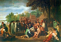
The Treaty of Shackamaxon, also called the Great Treaty and Penn's Treaty, was a treaty between William Penn and Tamanend of the Lenape signed in 1682. [1] Tamanend and Penn gifted each other and the people they represented with welcoming peace and friendship, vowing to "live together in peace as long as the creeks and rivers run and while the sun, moon, and stars endure." [2] [3] [4] [5] [6] [7] [8] [9] [10] [11] [12] [13] [14]

Contents

Description

Birch's Views of Philadelphia, an 1800 portrait City & Port of Philadelphia Birch's Views Frontispiece.jpg
Birch's Views of Philadelphia , an 1800 portrait
The wampum belt given to William Penn by the Indians at the "Great Treaty" under the Shackamaxon elm tree, 1682 The belt of wampum delivered by the Indians to William Penn at the "Great Treaty" (1682).jpg
The wampum belt given to William Penn by the Indians at the "Great Treaty" under the Shackamaxon elm tree, 1682

The site of the treaty was a meeting place that was used by the Lenape Native American tribe in North America. Situated near the Delaware River, this site was located within what now comprises the borders of present-day Philadelphia, Pennsylvania. [15]

Its name was derived from the Lenape term "Sakimauchheen Ing" (pronounced Sak-i-mauch-heen Ing) which means "to make a chief or king place"; called "Shackamaxon" by the English, Dutch, and Swedes. It was where the Lenapi "crowned" their many family "sakima" (chief) or their three clan "kitakima" (big or clan chief) of the Lenape Nation. Others have interpreted the name to mean "the place of eels", which refers to it as being an important summer fishing spot for the Native Americans. The area is the modern neighborhoods of Fishtown, Kensington, and Port Richmond in Philadelphia. [16]

William Penn, who purportedly did not arrive in North America until late October 1682, made a treaty with the Lenni Lenape under an ancient elm tree. Francis Jennings argues that William Penn very likely signed a treaty, but that his less scrupulous sons, William Jr., John, and Thomas, destroyed the original document. Through such means, according to Jennings, the younger Penns sought to renege on the treaty to which their father had agreed. [17] Curators of the Philadelphia History Museum at Atwater Kent claim that a wampum belt in their possession serves as authentication that such a meeting did indeed take place; however, the wampum belt cannot prove or disprove whether the Lenni Lenape and the colony came to a formal agreement, and if so, what the provisions of such an agreement entailed.

The legend of such a treaty was immortalized in several works of art (in particular, Benjamin West's paintings) and was mentioned by the French author Voltaire. The legendary elm tree marking the spot blew down in a storm on March 5, 1810. Its location was memorialized by the placing of an obelisk in 1827 by the Penn Society. The event was further memorialized by the founding of a park in 1893, known as Penn Treaty Park.

Six Swedish families were recorded as living in this area before Penn's arrival. The Swedes sold out to the new English settlers. During the eighteenth century, the territory of Shackamaxon was developed as part of the Port Richmond, Fishtown, and Kensington sections of Philadelphia. Today, there is a Shackamaxon Street in Philadelphia, which runs several blocks through Fishtown.

The Pennsylvania Historical and Museum Commission refers to the Shackamaxon treaty on its website. [18]

See also

Flag of Philadelphia, Pennsylvania.svg  Philadelphiaportal

Related Research Articles

<span class="mw-page-title-main">New Sweden</span> Former Swedish colony in North America

New Sweden was a colony of the Swedish Empire along the lower reaches of the Delaware River between 1638 and 1655 in present-day Delaware, Maryland, New Jersey, and Pennsylvania in the United States. Established during the Thirty Years' War when Sweden was a great power, New Sweden formed part of the Swedish efforts to colonize the Americas.

<span class="mw-page-title-main">Southampton, Pennsylvania</span> Unincorporated community in Pennsylvania, United States

Southampton is an unincorporated community located in Upper Southampton Township, Bucks County, Pennsylvania.

<span class="mw-page-title-main">Lenape</span> Indigenous people of the Northeastern Woodlands

The Lenape, also called the Lenni Lenape and Delaware people, are an Indigenous people of the Northeastern Woodlands, who live in the United States and Canada.

<span class="mw-page-title-main">Lenapehoking</span> Lands traditionally inhabited by the Lenape people

Lenapehoking is widely translated as 'homelands of the Lenape', which in the 16th and 17th centuries, ranged along the Eastern seaboard from western Connecticut to Delaware, and encompassed the territory adjacent to the Delaware and lower Hudson river valleys, and the territory between them.

<span class="mw-page-title-main">Province of Pennsylvania</span> British colony in North America (1681–1776)

The Province of Pennsylvania, also known as the Pennsylvania Colony, was a British North American colony founded by William Penn, who received the land through a grant from Charles II of England in 1681. The name Pennsylvania was derived from "Penn's Woods", referring to William's father Admiral Sir William Penn.

<span class="mw-page-title-main">Brandywine Creek (Christina River tributary)</span> Creek in Pennsylvania and Delaware, US

Brandywine Creek is a tributary of the Christina River in southeastern Pennsylvania and northern Delaware in the United States. The Lower Brandywine is 20.4 miles (32.8 km) long and is a designated Pennsylvania Scenic River with several tributary streams. The East Branch and West Branch of the creek originate within 2 miles (3 km) of each other on the slopes of Welsh Mountain in Honey Brook Township, Pennsylvania, about 20 miles (32 km) northwest of their confluence.

<span class="mw-page-title-main">Walking Purchase</span> 1737 agreement between the Penn family and the Lenape Native Americans

The Walking Purchase, also known as the Walking Treaty, was a 1737 agreement between the family of William Penn, the original proprietor of the Province of Pennsylvania, and the Lenape native Indians. In the purchase, the Penn family and proprietors claimed that a 1686 treaty with the Lenape ceded an area of 1,200,000 acres (4,860 km2) in present-day Lehigh Valley and Northeastern Pennsylvania in colonial Pennsylvania, which included a western land boundary extending as far west as a man could walk in a day and a half, which led to its name.

<span class="mw-page-title-main">Fishtown, Philadelphia</span> Neighborhood of Philadelphia in Philadelphia County, Pennsylvania, United States

Fishtown is a neighborhood in the River Wards section of Philadelphia, Pennsylvania, United States. Located northeast of Center City Philadelphia, its borders are somewhat disputed today due to many factors, but are roughly defined by the triangle created by the Delaware River, Front Street, and York Street. Some newer residents expand the area to Lehigh Avenue to the northeast, while some older residents shrink the area to Norris Street. It is served by the Market–Frankford Line rapid transit subway/elevated line of the SEPTA system. Fishtown was a largely working class Irish Catholic neighborhood, but has recently seen a large influx of young urban professionals and gentrification.

<span class="mw-page-title-main">Tamanend</span> Chief of the Lenni-Lenape nation

Tamanend was the Chief of Chiefs and Chief of the Turtle Clan of the Lenni-Lenape nation in the Delaware Valley signing the peace treaty with William Penn.

<span class="mw-page-title-main">Lappawinsoe</span> Lenape Chief

Lappawinsoe was a Lenape chief. His name signifies "gathering fruit" or "going away to gather food". Lappawinsoe sold the land of his tribe to Thomas Penn (1702-1775), and John Penn (1700-1746), the sons of William Penn (1644-1718), the founder, with moderate Quaker philosophies of the Colony and Province of Pennsylvania in 1681, through the controversial and disputed Walking Purchase treaty agreement of 1737. Three other Lenape-Delaware chiefs also signed the agreement: Tishecunk, Nutimus and Menakihikon. Documentation shows that Nutimus was considered the principal Indian leader of the tribes located further southeast in the future State of Delaware.

<span class="mw-page-title-main">Penn Treaty Park</span>

Penn Treaty Park is a small park on the western bank of the Delaware River, in the Fishtown neighborhood of Philadelphia, Pennsylvania. It is located on Beach Street, near its intersection with Delaware Avenue.

<i>Ulmus americana</i> Penn Treaty Elm cultivar

The American Elm cultivar Ulmus americana 'Penn Treaty' was raised by the Plant Sciences Data Center of the American Horticultural Society. Plants under that name were propagated by the Morris Arboretum, Pennsylvania, Philadelphia, from grafts made in 1945 from a tree at Haverford College, itself a graft, planted in 1840, from the Shackamaxon Treaty Elm – the tree under which William Penn signed his treaty with Native Americans in 1682 in what was later named Penn Treaty Park, Kensington, Pa.

<span class="mw-page-title-main">Petty Island</span>

Petty Island is a 292-acre (1.18 km2) island located in the Delaware River, which forms the border between Pennsylvania and New Jersey in the United States. The island is situated between the cities of Philadelphia, Pennsylvania and Camden, New Jersey and can be seen from both the Benjamin Franklin Bridge and the Betsy Ross Bridge. It is the fourth-largest island in the Delaware River's path. Petty Island is officially part of Pennsauken Township, New Jersey. In 2019, the State of New Jersey announced plans to buy the island, owned by Citgo, and make it a nature preserve.

<span class="mw-page-title-main">Six Nations land cessions</span> Iroquois and Lenape land cessions to the colonial and later independent U.S. (1682–1797)

The Six Nations land cessions were a series of land cessions by the Haudenosaunee and Lenape which ceded large amounts of land, including both recently conquered territories acquired from other indigenous peoples in the Beaver Wars, and ancestral lands to the Thirteen Colonies and the United States. The land ceded covered, partially or in the entire, the U.S. states of New York, Pennsylvania, Maryland, Virginia, West Virginia, Kentucky, Ohio, Tennessee and North Carolina. They were bordered to the west by the Algonquian lands in the Ohio Country, Cherokee lands to the south, and Muscogee and Choctaw lands to the southeast.

<i>Penns Treaty with the Indians</i> Painting by Benjamin West

The Treaty of Penn with the Indians, sometimes known as Penn's Treaty with the Indians at Shackamaxon or more simply Penn's Treaty with the Indians, is an oil painting by Benjamin West, completed in 1771–72. The painting depicts William Penn entering into the Treaty of Shackamaxon in 1683 with Tamanend, a chief of the Lenape Turtle Clan, under the shade of an elm tree near the village of Shackamaxon in Pennsylvania.

<i>Tamanend</i> (sculpture)

Tamanend was honored as the figurehead of USS Delaware in a carving by William Luke. Tamanend the “affable” was a chief of one of the clans that made up the Lenni-Lenape nation in the Delaware Valley. He is best known as a lover of peace and friendship who played a prominent role in the establishment of peaceful relations among the Native American tribes and the English settlers who established Pennsylvania, led by William Penn.

<span class="mw-page-title-main">Palmer Cemetery</span> Cemetery in the Fishtown neighborhood of Philadelphia, Pennsylvania, US

Palmer Cemetery, originally known as the Kensington Burial Grounds, was established around 1732 in the Fishtown section of Philadelphia.

Sassoonan or Allumapees was a Lenape chief who lived in the colonial-era Province of Pennsylvania in the late 17th and early 18th century. He was known for his negotiations with the provincial government of Pennsylvania in several land purchases. He was a respected leader until political intrigue and migration of the Lenape into the Ohio Country diminished his influence. During his final years he became dependent on alcohol and died in Shamokin in 1747. After his death the Lenape were without a chief until 1752, when the Iroquois half-king Tanacharison appointed Shingas to represent them at the Logstown Treaty conference. He was a son of Tamanend, also known as "Tammany," a well-respected Lenape sachem known as a lover of peace and friendship.

Pisquetomen was a Lenape chief who acted as interpreter and negotiator for the Lenape in dealings with the Provincial government of Pennsylvania during the mid-eighteenth century. After being rejected in his bid to succeed his uncle Sassoonan as Lenape chief, Pisquetomen joined Shingas and Captain Jacobs in a series of deadly attacks on Pennsylvania settlements at the beginning of the French and Indian War. He eventually participated in peace negotiations that led to the Treaty of Easton in 1758, and is believed to have died in 1762.

<span class="mw-page-title-main">Tamaqua (Lenape chief)</span> Lenape chief

Tamaqua or Tamaque, also known as The Beaver and King Beaver, was a leading man of the Unalachtigo (Turkey) phratry of the Lenape people. Although the Iroquois in 1752 had appointed Shingas chief of the Lenape at the Treaty of Logstown, after the French and Indian War Tamaqua rose in prominence through his active role as peace negotiator, and was acknowledged by many Lenape as their "king" or chief spokesman. He was among the first to hand over English captives at the end of the French and Indian War and was active in peace negotiations at the conclusion of Pontiac's War. By 1758, he was recognized as one of three principal leaders of the Lenape, being the primary spokesman for the western Lenape in the Ohio Country. He founded the town of Tuscarawas, Ohio, in 1756 and died there in 1769 or 1771.

References

  1. "Respectfully Remembering the Affable One".
  2. https://www.ustwp.org/government/boards-commissions/historical-advisory-board/chief-tamanend/
  3. https://hiddencityphila.org/2014/05/respectfully-remembering-the-affable-one/
  4. https://www.hmdb.org/m.asp?m=62016
  5. https://penntreatymuseum.org/history-2/peace-treaty/
  6. https://www.friendsoftamanend.org/history/
  7. https://sites.rowan.edu/diversity-equity-inclusion/blog/2023/10/land-acknowledgement-2023.html
  8. https://www.furman.edu/news/reconsidering-thanksgiving-and-native-american-heritage/
  9. https://www.nature.org/content/dam/tnc/nature/en/documents/DRB-Restoration-Roadmap_Shad-River-Herring_2022.pdf
  10. https://outwardboundphiladelphia.org/about/locations/
  11. https://rushtownship.org/about/history/
  12. https://www.delawarenation-nsn.gov/wp-content/uploads/2024/01/Volume_8_Edition_4_Delaware_Nation_October_-November_-December_2023_Newspaper_website.pdf
  13. https://hpacny.org/about/
  14. https://thecircle.sigmanursing.org/muomicronchapter/home
  15. "gilwell.com: the Lenape / English Dictionary" . Retrieved 30 January 2017.
  16. "gilwell.com: the Lenape / English Dictionary" . Retrieved 30 January 2017.
  17. Jennings, Francis (1975). The Invasion of America: Indians, Colonialism and the Cant of Conquest. W.W. Norton. p. 201. ISBN   0-393-00830-4.
  18. "www.phmc.state.pa.us. Shackamaxon Treaty". Archived from the original on 2015-08-13. Retrieved 2014-11-23.

39°57′58″N75°07′44″W / 39.966°N 75.129°W / 39.966; -75.129