Gardner Municipal Airport is a public airport located 2 nmi (3.7 km) southwest of the central business district of Gardner, a city in Worcester County, Massachusetts, United States. This airport is owned by the City of Gardner, and is located in the town of Templeton.
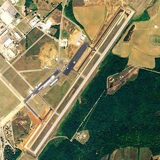
Talladega Municipal Airport is a city-owned public-use airport located eight nautical miles northeast of the central business district of Talladega, a city in Talladega County, Alabama, adjacent to Talladega Superspeedway in the city of Lincoln. It is included in the FAA's National Plan of Integrated Airport Systems for 2011–2015, which categorized it as a general aviation facility.

Florence Municipal Airport, is a public airport located in the city of Florence in Lane County, Oregon, USA. It is mostly used for general aviation.

Arlington Municipal Airport is a public airport located one mile (2 km) northeast of the central business district of Arlington, in Gilliam County, Oregon, United States. It is owned by the City of Arlington.
Ada Municipal Airport is a public airport located two miles (3 km) north of the central business district of Ada, a city in Pontotoc County, Oklahoma, United States. It is owned by the City of Ada, which is located in southeast Oklahoma, 88 miles (142 km) southeast of Oklahoma City.

Coeur d'Alene Airport is a county-owned public-use airport, located in Kootenai County, Idaho, United States. It is located nine miles (14 km) northwest of the central business district of Coeur d'Alene and is surrounded by the city of Hayden on three sides.
Clare Municipal Airport is a public airport located one mile (2 km) east of downtown Clare, a city in Clare County, Michigan, United States. The airport became active in 1941. It serves general aviation for Clare and the surrounding area. It is included in the Federal Aviation Administration (FAA) National Plan of Integrated Airport Systems for 2017–2021, in which it is categorized as a local general aviation facility.

Nebraska City Municipal Airport is four miles south of Nebraska City, in Otoe County, Nebraska.

Kissimmee Gateway Airport, formerly known as Kissimmee Municipal Airport, is a public airport in Kissimmee, a city in Osceola County, Florida, United States. The airport is located 16 nautical miles (30 km) southwest of the central business district of Orlando. It is owned and operated by the City of Kissimmee.
Arapahoe Municipal Airport is a public airport located two miles (3.2 km) north of the central business district of Arapahoe, a city in Furnas County, Nebraska, United States. It is owned by the Arapahoe Airport Authority.

Monticello Regional Airport, formerly known as Monticello Municipal Airport, is a public airport located two miles (3 km) southeast of the central business district of Monticello, a city in Jones County, Iowa, United States. It is owned by the City of Monticello.

La Porte Municipal Airport is a city-owned public-use airport located three miles (5 km) south of the central business district of La Porte, a city in La Porte County, Indiana, United States.

Dansville Municipal Airport is a public use airport located one nautical mile (2 km) northwest of the central business district of Dansville, a village in Livingston County, New York, United States. It is owned by the Town of North Dansville.
Northeast Iowa Regional Airport is a public airport located three miles (5 km) east of the central business district of Charles City, in Floyd County, Iowa, United States. It is owned by the North Cedar Aviation Authority and was formerly known as Charles City Municipal Airport.
Trenton Municipal Airport is a city-owned, public-use airport located one mile (2 km) east of the central business district of Trenton, a city in Grundy County, Missouri, United States.
Muscatine Municipal Airport is a city-owned public-use airport located five miles (8 km) southwest of the central business district of Muscatine, a city in Muscatine County, Iowa, United States.

Tower Municipal Airport is a city-owned public-use airport located one nautical mile northwest of the central business district of Tower, a city in Saint Louis County, Minnesota, United States. It is located on Lake Vermilion and is also known as Tower Municipal Airport & Seaplane Base.
Broken Bow Municipal Airport, also known as Keith Glaze Field, is a public use airport located two nautical miles (4 km) north of the central business district of Broken Bow, a city in Custer County, Nebraska, United States. It is owned by the Broken Bow Airport Authority. This airport is included in the National Plan of Integrated Airport Systems for 2011–2015, which categorized it as a general aviation facility.
Grant Municipal Airport is a city-owned, public-use airport located two nautical miles (4 km) north of the central business district of Grant, a city in Perkins County, Nebraska, United States. It is included in the National Plan of Integrated Airport Systems for 2011–2015, which categorized it as a general aviation airport.

Martin Municipal Airport is a city-owned, public-use airport located one nautical mile (2 km) southeast of the central business district of Martin, a city in Bennett County, South Dakota, United States. It is included in the National Plan of Integrated Airport Systems for 2011–2015, which categorized it as a general aviation facility.


