The geology of the Appalachians dates back to more than 480 million years ago. A look at rocks exposed in today's Appalachian Mountains reveals elongate belts of folded and thrust faulted marine sedimentary rocks, volcanic rocks and slivers of ancient ocean floor - strong evidence that these rocks were deformed during plate collision. The birth of the Appalachian ranges marks the first of several mountain building plate collisions that culminated in the construction of the supercontinent Pangaea with the Appalachians and neighboring Little Atlas near the center. These mountain ranges likely once reached elevations similar to those of the Alps and the Rocky Mountains before they were eroded.

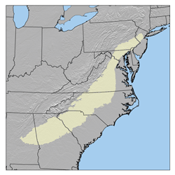
The Great Valley, also called the Great Appalachian Valley or Great Valley Region, is one of the major landform features of eastern North America. It is a gigantic trough—a chain of valley lowlands—and the central feature of the Appalachian Mountain system. The trough stretches about 1,200 miles (1,900 km) from Quebec to Alabama and has been an important north-south route of travel since prehistoric times.

The St. Francois Mountains in southeast Missouri are a mountain range of Precambrian igneous mountains rising over the Ozark Plateau. This range is one of the oldest exposures of igneous rock in North America. The name of the range is spelled out as Saint Francois Mountains in official GNIS sources, but it is sometimes misspelled in use as St. Francis Mountains to match the anglicized pronunciation of both the range and St. Francois County.

The Alleghanian orogeny or Appalachian orogeny is one of the geological mountain-forming events that formed the Appalachian Mountains and Allegheny Mountains. The term and spelling Alleghany orogeny was originally proposed by H.P. Woodward in 1957.

The Taconic orogeny was a mountain building period that ended 440 million years ago and affected most of modern-day New England. A great mountain chain formed from eastern Canada down through what is now the Piedmont of the East coast of the United States. As the mountain chain eroded in the Silurian and Devonian periods, sediments from the mountain chain spread throughout the present-day Appalachians and midcontinental North America.
Geographic regions of the Commonwealth of Pennsylvania, United States of America.

New Jersey is a state within the United States of America that lies on the north eastern edge of the North American continent. It shares a land border with the state of State of New York along the north, ratified by both states after the New York – New Jersey Line War. New Jersey is slightly larger than the country of Kuwait.

South Mountain is a colloquial name applied to features in the mountain range extending north and northeast from the Lebanon Valley to the Lehigh Valley regions of Pennsylvania. At times, it also been known as Texter Mountain, Durham Hills, Reading Hills, and the Lehigh Mountains. It is called the Reading Prong by geologists. The name South Mountain is applied to the southernmost cluster of peaks in the feature, straddling Berks, Lancaster, and Lebanon counties; and also to the northernmost end of the feature as the ridge into which Lehigh University is built.
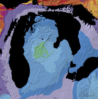
The Michigan Basin is a geologic basin centered on the Lower Peninsula of the US state of Michigan. The feature is represented by a nearly circular pattern of geologic sedimentary strata in the area with a nearly uniform structural dip toward the center of the peninsula.

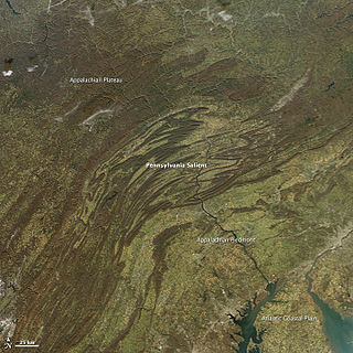
The Geology of Pennsylvania consists of six distinct physiographic provinces, three of which are subdivided into different sections. Each province has its own economic advantages and geologic hazards and plays an important role in shaping everyday life in the state. They are: the Atlantic Coastal Plain Province, the Piedmont Province, the New England Province, the Ridge and Valley Province, the Appalachian Plateau Province, and the Central Lowlands Province.

The Passaic Formation is a mapped bedrock unit in Pennsylvania, New Jersey, and New York. It was previously known as the Brunswick Formation since it was first described in the vicinity of New Brunswick, New Jersey. It is now named for the city of Passaic, New Jersey, which is near where its type section was described by paleontologist Paul E. Olsen.
New Jersey is a very geologically and geographically diverse region in the United States' Middle Atlantic region, offering variety from the Appalachian Mountains and the Highlands in the state's northwest, to the Atlantic Coastal Plain region that encompasses both the Pine Barrens and the Jersey Shore. The state's geological features have impacted the course of settlement, development, commerce and industry over the past four centuries.
The Reading Prong is a physiographic subprovince of the New England Uplands section of the New England province of the Appalachian Highlands. The prong consists of mountains made up of crystalline metamorphic rock.

The Belt Supergroup is an assemblage of primarily fine-grained sedimentary rocks and mafic intrusive rocks of late Precambrian (Mesoproterozoic) age. It is more than 15 kilometres (10 mi) thick, covers an area of some 200,000 km2, and is considered to be one of the world's best-exposed and most accessible sequences of Mesoproterozoic rocks. It was named after the Big Belt Mountains in west-central Montana. It is present in western Montana and northern Idaho, with minor occurrences in northwestern Washington and western Wyoming. It extends into Canada where the equivalent rocks, which are called the Purcell Supergroup, are exposed in southeastern British Columbia and southwestern Alberta. The rocks of the Belt Supergroup contain economically significant deposits of lead, zinc, silver, copper, gold, and other metals in a number of areas, and some of the Belt rocks contain fossil stromatolites.

The Ramapo Fault zone is a system of faults between the northern Appalachian Mountains and Piedmont areas to the east. Spanning more than 185 miles (298 km) in New York, New Jersey, and Pennsylvania, it is perhaps the best known fault zone in the Mid-Atlantic region, and some small earthquakes have been known to occur in its vicinity. Recently, public knowledge about the fault has increased, especially after the 1970s, when the fault's proximity to the Indian Point nuclear plant in New York was noted.

The geology of North America is a subject of regional geology and covers the North American continent, third-largest in the world. Geologic units and processes are investigated on a large scale to reach a synthesized picture of the geological development of the continent.

The Minisink or Minisink Valley is a loosely defined geographic region of the Upper Delaware River valley in northwestern New Jersey, northeastern Pennsylvania and New York.
The Mansfield Natural Gas Field is located west of Mansfield, Ohio, within the Appalachian foreland basin. The field is 1.5 miles long by 1.4 miles wide and is in a general oval shape, stretching northward. This field, although small, is an analog for many of the natural gas fields that occur within the Appalachian Basin. It was first discovered by the Pan American Petroleum and Transport Company in the early 1930's. It is part of the Utica – Lower Paleozoic system, which is estimated to make up 15 to 20 percent of the total hydrocarbon abundance of the Appalachian Basin.