The Soła is a river in southern Poland, a right tributary of the Vistula.

Gmina Łękawica is a rural gmina in Żywiec County, Silesian Voivodeship, in southern Poland. Its seat is the village of Łękawica, which lies approximately 6 kilometres (4 mi) north-east of Żywiec and 63 km (39 mi) south of the regional capital Katowice.
Gmina Łodygowice is a rural gmina in Żywiec County, Silesian Voivodeship, in southern Poland. Its seat is the village of Łodygowice, which lies approximately 6 kilometres (4 mi) north-west of Żywiec and 60 km (37 mi) south of the regional capital Katowice.

Wołowice is a village in the administrative district of Gmina Czernichów, within Kraków County, Lesser Poland Voivodeship, in southern Poland. It lies approximately 5 kilometres (3 mi) east of Czernichów and 18 km (11 mi) south-west of the regional capital Kraków.
Czernichów is a village in Żywiec County, Silesian Voivodeship, in southern Poland. It is the seat of the gmina called Gmina Czernichów. It lies approximately 7 kilometres (4 mi) north of Żywiec and 58 km (36 mi) south of the regional capital Katowice.
Międzybrodzie Bialskie is a village in the administrative district of Gmina Czernichów, within Żywiec County, Silesian Voivodeship, in southern Poland. It lies approximately 4 kilometres (2 mi) north-west of Czernichów, 11 km (7 mi) north of Żywiec, and 54 km (34 mi) south of the regional capital Katowice.
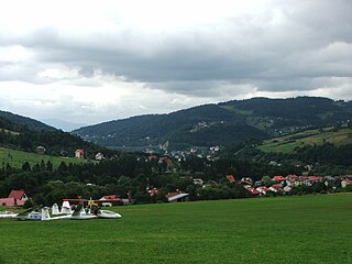
Międzybrodzie Żywieckie is a village in the administrative district of Gmina Czernichów, within Żywiec County, Silesian Voivodeship, in southern Poland. It lies approximately 2 kilometres (1 mi) north of Czernichów, 9 km (6 mi) north of Żywiec, and 56 km (35 mi) south of the regional capital Katowice.
Kocierz Moszczanicki is a village in the administrative district of Gmina Łękawica, within Żywiec County, Silesian Voivodeship, in southern Poland. It lies approximately 3 kilometres (2 mi) north-west of Łękawica, 6 km (4 mi) north-east of Żywiec, and 61 km (38 mi) south of the regional capital Katowice.
Łysina is a village in the administrative district of Gmina Łękawica, within Żywiec County, Silesian Voivodeship, in southern Poland. It lies approximately 3 kilometres (2 mi) north-east of Łękawica, 8 km (5 mi) north-east of Żywiec, and 61 km (38 mi) south of the regional capital Katowice.
Okrajnik is a village in the administrative district of Gmina Łękawica, within Żywiec County, Silesian Voivodeship, in southern Poland. It lies approximately 2 kilometres (1 mi) north of Łękawica, 7 km (4 mi) north-east of Żywiec, and 61 km (38 mi) south of the regional capital Katowice.

Pietrzykowice is a village in the administrative district of Gmina Łodygowice, within Żywiec County, Silesian Voivodeship, in southern Poland. It lies approximately 5 kilometres (3 mi) south of Łodygowice, 5 km (3 mi) west of Żywiec, and 64 km (40 mi) south of the regional capital Katowice. The village has a population of 4,279.

Bystra is a village in the administrative district of Gmina Radziechowy-Wieprz, within Żywiec County, Silesian Voivodeship, in southern Poland. It lies approximately 3 kilometres (2 mi) south-east of Wieprz, 8 km (5 mi) south of Żywiec, and 72 km (45 mi) south of the regional capital Katowice.

Las is a village in the administrative district of Gmina Ślemień, within Żywiec County, Silesian Voivodeship, in southern Poland. It lies approximately 4 kilometres (2 mi) north-east of Ślemień, 16 km (10 mi) east of Żywiec, and 65 km (40 mi) south-east of the regional capital Katowice.
Cicha is a village in the administrative district of Gmina Ujsoły, within Żywiec County, Silesian Voivodeship, in southern Poland, close to the border with Slovakia. It lies approximately 3 kilometres (2 mi) south of Ujsoły, 28 km (17 mi) south of Żywiec, and 90 km (56 mi) south of the regional capital Katowice.

Glinka is a village in the administrative district of Gmina Ujsoły, within Żywiec County, Silesian Voivodeship, in southern Poland, close to the border with Slovakia. It lies approximately 3 kilometres (2 mi) east of Ujsoły, 26 km (16 mi) south of Żywiec, and 89 km (55 mi) south of the regional capital Katowice.

Młada Hora is a village in the administrative district of Gmina Ujsoły, within Żywiec County, Silesian Voivodeship, in southern Poland, close to the border with Slovakia.
Stawiska is a village in the administrative district of Gmina Ujsoły, within Żywiec County, Silesian Voivodeship, in southern Poland, close to the border with Slovakia. It lies approximately 3 kilometres (2 mi) west of Ujsoły, 26 km (16 mi) south of Żywiec, and 87 km (54 mi) south of the regional capital Katowice.

Żabnica is a village in the administrative district of Gmina Węgierska Górka, within Żywiec County, Silesian Voivodeship, in southern Poland. It lies approximately 3 kilometres (2 mi) south-east of Węgierska Górka, 13 km (8 mi) south of Żywiec, and 76 km (47 mi) south of the regional capital Katowice.
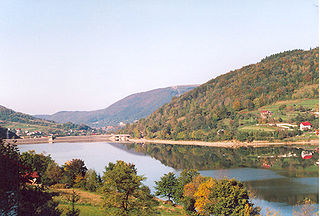
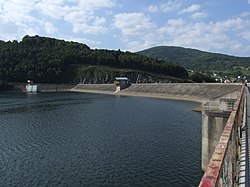
Żywiec Lake is a reservoir on the Soła river in southern Poland, near the town of Żywiec. It was created in 1966, when several villages in the area, such as Zarzecze, Tresna, Zadziel and Old Żywiec were flooded following the construction of a dam. The lake has the area of around 10 square kilometres, and the earth-filled dam is 39 metres high and 310 metres long. The maximum depth of the lake is 26,8 meters, and the average depth - 8,6 metres. Near the dam there is a hydro-electric power plant with the capacity of 21 MW. Żywiec Lake is used mostly for tourist purposes, to regulate the flow of water, and to protect the area from flooding.