This article needs additional citations for verification .(February 2015) |

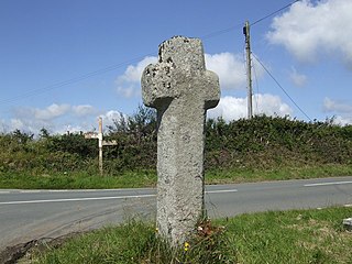
Treveighan (Cornish : Trevegan [1] ) is a village in the parish of Michaelstow, Cornwall, England, United Kingdom. It is half a mile northwest of Michaelstow. [2]
This article needs additional citations for verification .(February 2015) |
Treveighan (Cornish : Trevegan [1] ) is a village in the parish of Michaelstow, Cornwall, England, United Kingdom. It is half a mile northwest of Michaelstow. [2]

Morwenstow is a civil parish in north Cornwall, England, UK. The parish abuts the west coast, about six miles (10 km) north of Bude and within the Cornwall Area of Outstanding Natural Beauty (AONB).
Bedard Aspen Provincial Park is a provincial park in British Columbia, Canada, located in the Cornwall Hills to the west of Cache Creek-Ashcroft in that province's Thompson Country region. The valley of Hat Creek is to its west.
Blue Earth Lake Provincial Park is a provincial park in the Upper Hat Creek area at the south end of the Cornwall Hills, just northwest of Ashcroft, British Columbia, Canada.
Cornwall Hills Provincial Park is a provincial park in British Columbia, Canada, immediately west of Cache Creek, protecting part of the Cornwall Hills including their highest summit which features an old fire lookout.
There are seventeen disused railway stations on the Cornish Main Line between Plymouth in Devon and Penzance in Cornwall, England. The remains of nine of these can be seen from passing trains. While a number of these were closed following the so-called "Beeching Axe" in the 1960s, many of them had been closed much earlier, the traffic for which they had been built failing to materialise.

The River Inny is a small river in east Cornwall, United Kingdom. It is a tributary of the River Tamar and is about twenty miles (32 km) long from its source near Davidstow on the eastern flank of Bodmin Moor to its confluence with the Tamar at Inny Foot near Dunterton.

SS James Eagan Layne was a liberty ship. She was beached and sunk during the Second World War off Whitsand Bay, Cornwall, United Kingdom.
SS Eastfield was a 2,150-ton armed steamship which was torpedoed by the German U-boat SM UB-57 on 27 November 1917. The wreck sits intact at 50°14.255′N4°42.262′W at a depth of 50 metres (160 ft) off Mevagissey, Cornwall. The cargo of coal can be found scattered on the sea bed nearby.
Dobwalls and Trewidland is a former civil parish in south-east Cornwall, England, United Kingdom.

The River Allen in north Cornwall is one of two rivers in Cornwall which share this name. In this case the name is the result of a mistake made in 1888 by Ordnance Survey, replacing the name Layne with Allen which is the old name for the lower reaches of the Camel. The other River Allen runs through Truro.

The River Ottery is a small river in northeast Cornwall, United Kingdom. The river is about twenty miles (32 km) long from its source southeast of Otterham to its confluence with the River Tamar at Nether Bridge, two miles (3.2 km) northeast of Launceston.

The De Lank River is a small river in north Cornwall, England. It is a tributary of the River Camel and is approximately nine miles (14.5 km) long from its source on Bodmin Moor to its confluence with the Camel two miles (3 km) south of St Breward.
John Sill was an English politician who sat in the House of Commons in 1659 and 1660.

Fentonadle is a hamlet situated 4 miles (6.4 km) south-west from Camelford in Cornwall, England. Fentonadle lies at around 120 metres (390 ft) above sea level in the civil parish of Michaelstow situated on the western side of the River Camel valley and to the north-west of Bodmin Moor. It is in the civil parish of St Breward
Camelford Rural District was a local government division of north Cornwall between 1894 and 1974. The district council offices were at Camelford, Cornwall, England, UK, latterly in the former grammar school. It was one of several rural districts in Cornwall which carried out some local government functions while those for Cornwall as a whole were the responsibility of the Cornwall County Council.
Mullies is one of several variant surnames found in England, the most prevalent being MULLIS. Its first appearance is in Michaelstow Parish in Cornwall in the records of Court of Star Chamber which, in 1585, recorded individuals interchangeably as MULLYS, MULLIS, MULLES and MULLIES.<1 Court of Star Chamber, PRO B10/20 60/5,82/20/107/27. /ref>

The River Kensey is a river in east Cornwall, England, UK which is a tributary of the River Tamar.

The Battle of Hingston Down took place in 838 at Hingston Down in Cornwall between a combined force of Cornish and Vikings on the one side, and West Saxons led by Egbert, King of Wessex on the other. It resulted in a West Saxon victory.

The River Seaton is a river in east Cornwall, England, UK which flows southwards for 11 miles (17 km) into the English Channel.

The River Lerryn is a river in east Cornwall, England, UK, a tributary of the River Fowey. The Lerryn is the largest of the tributaries which enter the estuary of the Fowey. The river is tidal up to the village of Lerryn. The landscape of the Lerryn catchment is rural and includes heathland, moorland and rough pasture in the upper reaches and broadleaf, coniferous and mixed plantation woodland in the lower. This catchment includes four SSSIs, including Redlake Meadows & Hoggs Moor. The Lerryn rises at Fairy Cross on the southern slopes of Bodmin Moor and flows south-southwest until it enters the Fowey estuary.
Coordinates: 50°35′07″N4°43′15″W / 50.5852823°N 4.720714°W
| | This Cornwall location article is a stub. You can help Wikipedia by expanding it. |