
Jefferson County is a county located in the U.S. state of Florida. As of the 2010 census, the population was 14,761. Its county seat is Monticello.

Saline County is a county in the U.S. state of Nebraska. As of the 2010 United States Census, the population was 14,200. Its county seat is Wilber.

Morrill County is a county in the U.S. state of Nebraska. As of the 2010 United States Census, the population was 5,042. Its county seat is Bridgeport.

Banner County is a county in the western part of the state of Nebraska in the Great Plains region of the United States. As of the 2010 United States Census, its population was 690. Its county seat is the unincorporated community of Harrisburg; there are no incorporated municipalities within the county.
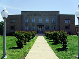
Lincoln County is located between the Arkansas Timberlands and Arkansas Delta in the U.S. state of Arkansas. It is also within the Pine Bluff metro area, and on the outer edge of the Central Arkansas region. The county is named for Abraham Lincoln, the 16th President of the United States. Created as Arkansas's 65th county on March 28, 1871, Lincoln County has three incorporated cities, including Star City, the county seat and most populous city. The county contains 46 unincorporated communities and ghost towns, Cane Creek State Park at the confluence of Cane Creek and Bayou Bartholomew, and nine listings on the National Register of Historic Places to preserve the history and culture of the county.

Jefferson County, Arkansas is a county located in the U.S. state of Arkansas in the area known as the Arkansas Delta, that extends west of the Mississippi River. As of the 2010 census, the population was 77,435. Its county seat and largest city is Pine Bluff. Jefferson County is Arkansas's 21st county, formed on November 2, 1829, from portions of Arkansas and Pulaski counties, and named for Thomas Jefferson, third President of the United States. Jefferson County is included in the Pine Bluff, Arkansas Metropolitan Statistical Area. The county is bisected by the Arkansas River, which was critical to its development and long the chief transportation byway.

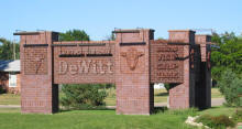
Arkansas County is a county located in the U.S. state of Arkansas. As of the 2010 census, the population was 19,019. Located in the Arkansas Delta, the county has two county seats, De Witt and Stuttgart.
De Witt is a village in Saline County, Nebraska, United States. The population was 513 at the 2010 census.

Cuero is a city in DeWitt County, Texas, United States. The population was 6,841 at the 2010 census. It is the county seat of DeWitt County. It is unofficially known as the "turkey capital of the world". In 2010, Cuero was named one of the "Coolest Small Towns in America" by Budget Travel magazine.
Sioux City is a city in Woodbury and Plymouth counties in the northwestern part of the U.S. state of Iowa. The population was 82,684 in the 2010 census, which makes it the fourth largest city in Iowa. The bulk of the city is in Woodbury County, of which it is the county seat, though a small portion is in Plymouth County. Sioux City is located at the navigational head of the Missouri River. The city is home to several cultural points of interest including the Sioux City Public Museum, Sioux City Art Center and Sergeant Floyd Monument, which is a National Historic Landmark. The city is also home to Chris Larsen Park, commonly referred to as “the Riverfront,” includes the Anderson Dance Pavilion, Sergeant Floyd Riverboat Museum and Lewis and Clark Interpretive Center. Sioux City is the primary city of the five-county Sioux City, IA–NE–SD Metropolitan Statistical Area (MSA), with a population of 168,825 in 2010 and a slight increase to an estimated 168,921 in 2012. The Sioux City–Vermillion, IA–NE–SD Combined Statistical Area had a population of 182,675 as of 2010 and has grown to an estimated population of 183,052 as of 2012.
DeWitt School District is a school district based in the town of DeWitt, Arkansas, United States. The DeWitt School District is geographically the state's largest school district with 872.29 square miles (2,259.2 km2) of land and 46.18 square miles (119.6 km2) of water, encompassing portions of the Arkansas County, Jefferson County, and Desha County.

Brilliant is an unincorporated community and census-designated place (CDP) in eastern Jefferson County, Ohio, United States, along the Ohio River. It was named after the Brilliant Glass factory that once was located in the town. Although unincorporated, Brilliant has a post office, bearing the ZIP code 43913. It is located along Ohio State Route 7. Brilliant is part of the Weirton-Steubenville, WV-OH Metropolitan Statistical Area. As of the 2010 census it had a population of 1,482.
U.S. Highway 30 (US 30) is a major east–west U.S. Highway which spans 330 miles (530 km) across the state of Iowa. It is the longest primary highway in the state and is maintained by the Iowa Department of Transportation. The route in Iowa begins at the Missouri River crossing at Blair, Nebraska, and ends at the Mississippi River crossing at Clinton. Along the way, it serves Denison and Carroll in western Iowa, Boone, Ames, and Marshalltown in central Iowa, and Tama, Cedar Rapids, and DeWitt in eastern Iowa. Cutting across the central portion of the state, US 30 runs within close proximity of the Union Pacific Railroad's Overland Route for its entire length.

Lake McConaughy is a reservoir on the North Platte River. It is located 9 miles (14 km) north of Ogallala, Nebraska, United States, near U.S. Highway 26 and Nebraska Highway 61. The reservoir was named for Charles W. McConaughy, a grain merchant and mayor of Holdrege, Nebraska, one of the leading promoters of the project. Although he did not live to see the completion of the project, his leadership and perseverance eventually culminated in a public power and irrigation project that helped Nebraska become one of the nation's leading agricultural states.

Nebraska Highway 103 is a highway in southeastern Nebraska. It is a discontinuous highway with two segments. The southern segment begins at Nebraska Highway 8 south of Diller and ends at U.S. Highway 136 north of Diller. The northern segment begins at Nebraska Highway 4 east of Plymouth and ends at Interstate 80 north of Pleasant Dale.
U.S. Highway 75 is a part of the United States Numbered Highway System that runs for 1,239 miles (1,994 km) from Dallas, Texas to Kittson County, Minnesota where it ends just short of the Canada–United States border. Within the State of Nebraska it is a state highway that enters Nebraska on the Kansas state line about 9 miles (14 km) south of Dawson and travels north across the extreme eastern portion of the state, to the Nebraska–Iowa border in South Sioux City where it crosses the Missouri River along a concurrency with Interstate 129. The northern 210 miles (340 km) of the route generally travels parallel to the Missouri River. The 87.32-mile (140.53 km) section between the I-680 interchange in Omaha and the Interstate 129 interchange is designated the Lewis & Clark Scenic Byway, one of nine scenic byways in the state.

De Witt is a city in Clinton County, Iowa, United States. The population was 5,322 at the 2010 census, which is a 5.2% increase from the 2000 census, making it the fastest growing city in Clinton County.

Witts Springs is an unincorporated community in Searcy County, Arkansas, United States. Witts Springs is located on Arkansas Highway 16, 16.5 miles (26.6 km) southwest of Marshall. Witts Springs has a post office with ZIP code 72686.

Eli is an unincorporated community in Cherry County, Nebraska, in the United States. Its population is around 60-75 people, but exact Census information has not been collected. It is 1 mile north of U.S. Highway 20 and 2.5 miles south of the Nebraska-South Dakota border. The nearest town is Merriman, Nebraska, 11.8 miles to the west. It is also 12.8 miles west of Cody, Nebraska.


