Trlično

Last updated
Trlično
Slovenia location map.svg
Red pog.svg
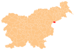
Trlično
Location in Slovenia
Coordinates: 46°12′52″N15°46′42.37″E / 46.21444°N 15.7784361°E / 46.21444; 15.7784361 Coordinates: 46°12′52″N15°46′42.37″E / 46.21444°N 15.7784361°E / 46.21444; 15.7784361
Country Flag of Slovenia.svg Slovenia
Traditional region Styria
Statistical region Savinja
Municipality Rogatec
Area
  Total 0.85 km2 (0.33 sq mi)
Elevation 261.3 m (857.3 ft)
Population (2002)
  Total 110
[1]

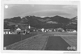
Trlično (pronounced  [təɾˈliːtʃnɔ] ) is a settlement in the Municipality of Rogatec in eastern Slovenia. It is a dispersed settlement that stretches along the border with Croatia east of Dobovec pri Rogatcu. The entire Rogatec area traditionally belonged to the Styria region. It is now included in the Savinja Statistical Region. [2]

Municipality of Rogatec Municipality in Slovenia

The Municipality of Rogatec is a municipality in eastern Slovenia, on the border with Croatia. The seat of the municipality is the town of Rogatec. The area traditionally belonged to the region of Styria. It is now included in the Savinja Statistical Region. The municipality was established in its current form on 3 October 1994, when the former larger Municipality of Šmarje pri Jelšah was subdivided into the municipalities of Kozje, Podčetrtek, Rogaška Slatina, Rogatec, and Šmarje pri Jelšah.

Slovenia republic in Central Europe

Slovenia, officially the Republic of Slovenia, is a sovereign state located in southern Central Europe at a crossroads of important European cultural and trade routes. It is bordered by Italy to the west, Austria to the north, Hungary to the northeast, Croatia to the southeast, and the Adriatic Sea to the southwest. It covers 20,273 square kilometers (7,827 sq mi) and has a population of 2.07 million. One of the successor states of the former Yugoslavia, Slovenia is a parliamentary republic and a member of the United Nations, of the European Union, and of NATO. The capital and largest city is Ljubljana.

Dispersed settlement Rural settlement type, typically consists of widely spaced farmsteads without an actual nucleus

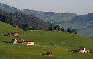
A dispersed settlement, also known as a scattered settlement, is one of the main types of settlement patterns used by landscape historians to classify rural settlements found in England and other parts of the world. Typically, there are a number of separate farmsteads scattered throughout the area. A dispersed settlement contrasts with a nucleated village.

Contents

Mass grave

Trlično is the site of a mass grave from the end of the Second World War. The Trlično Mass Grave (Slovene : Grobišče Trlično) is located along Sotla Creek, 300 m east of the border crossing at Dobovec pri Rogatcu. It contains the remains of several dozen Croatians, and perhaps also Banat Swabians, that were killed in May 1945. [3]

Mass graves in Slovenia

Mass graves in Slovenia were created in Slovenia as the result of extrajudicial killings during and after the Second World War. They are known as "concealed mass graves" or "silenced mass graves" because their existence was concealed under the communist regime from 1945 to 1990.

Slovene language language spoken in Slovenia

Slovene or Slovenian belongs to the group of South Slavic languages. It is spoken by approximately 2.5 million speakers worldwide, the majority of whom live in Slovenia. It is the first language of about 2.1 million Slovenian people and is one of the 24 official and working languages of the European Union.

Dobovec pri Rogatcu Place in Styria, Slovenia

Dobovec pri Rogatcu is a settlement east of the town of Rogatec in eastern Slovenia. The area traditionally belonged to the Styria region. It is now included in the Savinja Statistical Region.

Related Research Articles

Rogatec Place in Styria, Slovenia

Rogatec is a small town in eastern Slovenia, on the border with Croatia. It is the seat of the Municipality of Rogatec. The area traditionally belonged to the region of Styria. It is now included in the Savinja Statistical Region.

Šmartno pri Slovenj Gradcu Place in Styria, Slovenia

Šmartno pri Slovenj Gradcu is a settlement in the City Municipality of Slovenj Gradec in northern Slovenia. The area was traditionally part of Styria. The entire municipality is now included in the Carinthia Statistical Region.

Slope, Hrpelje-Kozina in Littoral, Slovenia

Slope is a village east of Hrpelje in the Municipality of Hrpelje-Kozina in the Littoral region of Slovenia close to the border with Croatia.

Dolenje pri Jelšanah Place in Inner Carniola, Slovenia

Dolenje pri Jelšanah is a village north of Jelšane in the Municipality of Ilirska Bistrica in the Inner Carniola region of Slovenia, next to the border with Croatia. The settlement includes the hamlets of Dolnji Kraj, Gornji Kraj, and Vrh Žloštajna.

Jelšane Place in Inner Carniola, Slovenia

Jelšane is a village in the Municipality of Ilirska Bistrica in the Inner Carniola region of Slovenia, right on the border with Croatia. The Jelšane international border crossing between Slovenia and Croatia is just south of the village.

Novokračine Place in Inner Carniola, Slovenia

Novokračine is a village east of Jelšane in the Municipality of Ilirska Bistrica in the Inner Carniola region of Slovenia on the border with Croatia.

Sušak, Ilirska Bistrica in Inner Carniola, Slovenia

Sušak is a small village in the Municipality of Ilirska Bistrica in the Inner Carniola region of Slovenia, close to the border with Croatia.

Zabiče Place in Inner Carniola, Slovenia

Zabiče is a village in the Municipality of Ilirska Bistrica in the Inner Carniola region of Slovenia, close to the border with Croatia.

Kozarišče Place in Inner Carniola, Slovenia

Kozarišče is a village south of Stari Trg pri Ložu in the Municipality of Loška Dolina in the Inner Carniola region of Slovenia. The area of the village extends south of the main settlement right to the Snežnik Plateau and to the border with Croatia. Snežnik Castle, a 13th-century castle, is located just southwest of the village.

Šentjanž pri Dravogradu Place in Styria, Slovenia

Šentjanž pri Dravogradu is a settlement on the left bank of the Mislinja River south of Dravograd in northern Slovenia, in the traditional region of Styria.

Brezovec pri Rogatcu in Styria, Slovenia

Brezovec pri Rogatcu is a settlement west of the town of Rogatec in eastern Slovenia. The area traditionally belonged to the Styria region. It is now included in the Savinja Statistical Region.

Strmec pri Svetem Florijanu Place in Styria, Slovenia

Strmec pri Svetem Florijanu is a settlement in the Municipality of Rogaška Slatina in eastern Slovenia. The entire area was traditionally part of the region of Styria. It is now included in the Savinja Statistical Region.

Tuncovec in Styria, Slovenia

Tuncovec is a settlement in the Municipality of Rogaška Slatina in eastern Slovenia. It lies east of the town of Rogaška Slatina, between Spodnje Sečovo and Brezovec pri Rogatcu. The wider area around Rogaška Slatina was traditionally part of the region of Styria. It is now included in the Savinja Statistical Region.

Stari Grad, Krško in Styria, Slovenia

Stari Grad is a settlement east of the town of Krško in eastern Slovenia. The area was traditionally part of Styria. It is now included with the rest of the municipality in the Lower Sava Statistical Region.

Selo pri Pancah Place in Lower Carniola, Slovenia

Selo pri Pancah is a small settlement in the City Municipality of Ljubljana in central Slovenia. It lies in the hills southwest of the capital Ljubljana. The area was part of the traditional region of Lower Carniola and is now included with the rest of the municipality in the Central Slovenia Statistical Region.

Dobovec, Trbovlje Place in Lower Carniola, Slovenia

Dobovec is a settlement in the Municipality of Trbovlje in central Slovenia. It lies in the hills above the right bank of the Sava River. Traditionally the area was part of the Lower Carniola region. It is now included with the rest of the municipality in the Central Sava Statistical Region.

Lahomno Place in Styria, Slovenia

Lahomno is a settlement in the Municipality of Laško in eastern Slovenia. It lies in the valley of Lahomnica Creek, a minor left tributary of the Savinja River east of Laško. The area was traditionally part of the Styria region. It is now included with the rest of the municipality in the Savinja Statistical Region.

Reka, Laško in Styria, Slovenia

Reka is a settlement in the Municipality of Laško in eastern Slovenia. It lies in hills east of Laško. The area was traditionally part of the Styria region. It is now included with the rest of the municipality in the Savinja Statistical Region.

References