
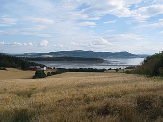
Straumen is the administrative centre of the municipality of Inderøy in Trøndelag county, Norway. It is located along the Trondheimsfjord at the northeastern side of the Inderøya peninsula, next to the Børgin fjord. The village lies about 2 kilometres (1.2 mi) east of the village of Sakshaug and about 7 kilometres (4.3 mi) west of the villages of Røra and Hylla. The village has a slaughterhouse, a folk high school, and a museum. The Sakshaug Church and the historic Old Sakshaug Church lie just west of Straumen.
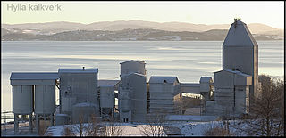
Hylla is a village in the municipality of Inderøy in Trøndelag county, Norway. Hylla is located along the Trondheimsfjord, about 2 kilometres (1.2 mi) south of the village of Røra and about 8 kilometres (5.0 mi) east of the villages of Straumen and Sakshaug. The village is home to a large limestone quarry and processing facility.
Gangstadhaugen or Gangstad is a village in the municipality of Inderøy in Trøndelag county, Norway. It is located on the northern part of the Inderøya peninsula, near the shore of the Beitstadfjorden, about 1.5 kilometres (0.93 mi) southeast of the village of Breivika. Hustad Church is located about 1 kilometre (0.62 mi) north of the village.
Røra is a village in Inderøy municipality in Trøndelag county, Norway. The village is located on a small peninsula between the Trondheimsfjorden and the Børgin fjord. The village is located about 7 kilometres (4.3 mi) north of the town of Verdalsøra and about 20 kilometres (12 mi) south of the town of Steinkjer. The village of Hylla lies just south of Røra and the municipal centre of Straumen lies a short distance to the west.
Breivika or Breidvik is a village in the municipality of Inderøy in Trøndelag county, Norway. It is located along the Trondheimsfjord in the northern part of the Inderøya peninsula, about 1.5 kilometres (0.93 mi) northwest of the village of Gangstadhaugen.
Utøy or Utøya is a village area in the municipality of Inderøy in Trøndelag county, Norway. The village sits about half way between the village of Vangshylla and the village of Sakshaug. The village of Kjerknesvågen lies about 6 kilometres (3.7 mi) to the north and the Trondheimsfjord lies just to the south. The "Utøy area" generally includes the area around the village which is the southern part of the Inderøya peninsula.
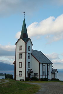
Sakshaug is a village in the municipality of Inderøy in Trøndelag county, Norway. It is located on the Inderøya peninsula, about 1.5 kilometres (0.93 mi) northwest of the municipal center of Straumen and about 5 kilometres (3.1 mi) northeast of the village of Utøy. The village is considered part of the Straumen urban area by Statistics Norway, so no separate population statistics are tracked.
Venneshamn is a village in the municipality of Inderøy in Trøndelag county, Norway. It is located along the Trondheimsfjord on the northeastern end of the Fosen peninsula. The village is located about 10 kilometres (6.2 mi) north of the village of Mosvik, and about 5 kilometres (3.1 mi) north of the village of Kjerringvika and the Skarnsund Bridge that crosses the Skarnsundet. The village of Framverran lies about 4 kilometres (2.5 mi) northwest of Venneshamn. Verran Sparebank was based in Venneshamn until 2006 when it merged with Grong Sparebank. There was also a general store here until it closed in August 2008.

Kjerknesvågen is a village in the municipality of Inderøy in Trøndelag county, Norway. It is located along the Trondheimsfjord on the northwestern shore of the Inderøya peninsula, about 8 kilometres (5.0 mi) north of the village of Utøy.
Sandvollan is a former municipality in the old Nord-Trøndelag county, Norway. The 28-square-kilometre (11 sq mi) municipality existed from 1907 until its dissolution in 1962. It was located in the north part of what is now the municipality of Inderøy in Trøndelag county. There are two main villages in Sandvollan: Gangstad and Småland. Gangstad has a grocery store. Between the two villages lies Skjelvågen, a harbour that used to be a stop on the steam ship routes.

Skarnsund or Skarnsundet is a strait in the Trondheimsfjord in Trøndelag county, Norway. The strait connects the Beitstadfjorden with the outer section of the Trondheimsfjorden. The 5-kilometre (3.1 mi) long and 0.5-kilometre (0.31 mi) wide Skarnsund is located in the municipality of Inderøy. On the northeastern side of the strait is the village of Vangshylla and on the southwestern side is the villages of Venneshamn and Kjerringvik. The strait has a strong tidal current with a maelstrom.
Kjerringvika or Kjerringvik is a village located in the municipality of Inderøy in Trøndelag county, Norway. It is located on the shore of the Trondheimsfjord at the Skarnsund strait, about 5 kilometres (3.1 mi) northeast of the village of Mosvik.

Norwegian County Road 755 is a county road in Trøndelag county, Norway. The 91.2-kilometre (56.7 mi) road runs from the village of Røra in the municipality of Inderøy to the village of Vanvikan in Indre Fosen municipality. It was known as Norwegian National Road 755 before 2010 when control of the road was transferred from the national government to the county.
Framverran is a village in the municipality of Inderøy in Trøndelag county, Norway. It is located about 15 kilometres (9.3 mi) from the village of Mosvik, about 4 kilometres (2.5 mi) northwest of the village of Venneshamn, and about 15 kilometres (9.3 mi) northeast of Trongsundet. The village sits along the Beitstadfjorden, southeast of the mouth of the Verrasundet and northwest of the mouth of the Skarnsund.
Verrabotn is a village located in the municipality of Verran in Trøndelag county, Norway. It is located at end of the Verrasundet arm of the Trondheimsfjord. The village of Verrastranda lies about 20 kilometres (12 mi) to the northeast, the village of Trongsundet lies about 10 kilometres (6.2 mi) to the northeast, and the village of Årnset lies about 40 kilometres (25 mi) to the southwest. Norwegian National Road 720 runs through the village, which formerly had a primary school. The village is the location of Fines Church.
Beitstadfjorden is the innermost arm of the Trondheimsfjord in Trøndelag county, Norway. It is located in the municipalities of Steinkjer, Inderøy, and Verran. The fjord has a length of 28 kilometres (17 mi) from southwest to northeast, and a width of about 6 to 8 kilometres.
Verrasundet is a fjord in Trøndelag county, Norway. The 22-kilometre (14 mi) long fjord branches off of the northern part of the vast Trondheimsfjorden in the municipalities of Verran and Inderøy. It extends from Beitstadfjorden to the village of Verrabotn. The fjord is a maximum of 2 kilometres (1.2 mi) wide, but at Trongsundet, the fjord is barely 200 metres (660 ft) wide.

Mosvik is a village in Inderøy municipality in Trøndelag county, Norway. The village is located on the western shore of the Trondheimsfjorden, just south of the Skarnsundet strait and the Skarnsund Bridge. The island of Ytterøya lies offshore about 3 kilometres (1.9 mi) southeast of the village of Mosvik. Mosvik Church is located in the village. From 1901 until 2012, the village was the administrative centre of the old municipality of Mosvik.
Røra is a former municipality in the old Nord-Trøndelag county, Norway. The 29-square-kilometre (11 sq mi) municipality existed from 1907 until its dissolution in 1962. It was located at the northeastern end of the Trondheimsfjorden, just north of the towns of Verdalsøra and Levanger. It is located in what is now the southeastern part of Inderøy municipality in Trøndelag county. The administrative centre of the municipality was the village of Røra where Salberg Church is located.


