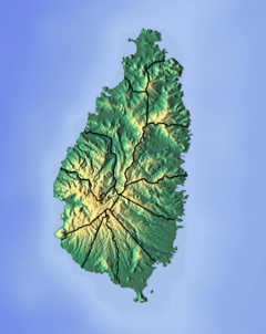
The Cul De Sac River is a river in Castries Quarter of the island country of Saint Lucia. It flows north and then west from the central highlands in the south of the island, reaching the Caribbean Sea in Grand Cul de Sac Bay, south of the capital, Castries. It is one of the longest rivers in Saint Lucia.

The Roseau River is a river in the Anse-la-Raye Quarter of the island country of Saint Lucia. It flows north and then west from the central highlands in the south of the island, reaching the Caribbean Sea to the north of the town of Anse la Raye. The Roseau river is also the longest in the country and is dammed by the John Compton Dam near Millet.

The Castries River is a river in Castries Quarter on the island county of Saint Lucia.

The Dorée River is a river on the island of Saint Lucia.

The Migny River is a river on the island of Saint Lucia.

The Anse Cochon River is a river in Saint Lucia.

The Dauphin River is a river in Gros Islet Quarter, Saint Lucia.

The Ger River is a river of Saint Lucia.

The La Verdure River is a river of Saint Lucia.

The Mamiku River is a river of Saint Lucia.

The Mamin River is a river of Saint Lucia.

The Marquis River is a river of Saint Lucia.

The Millet River is a river of Saint Lucia.

The Patience River is a river of Saint Lucia.

The Praslin River is a river of Saint Lucia.

The Trou Barbet River is a river of Saint Lucia.

The Trou Sallé River is a river of Saint Lucia.

The Volet River is a river of Saint Lucia.

Canaries District is one of 10 districts of the island nation of St. Lucia in the Caribbean Sea. In 2010, the population of the region was 2,009 people, and they are mainly fishers and agricultural workers. The main town in the area takes the same name as the district and is located down the western coast from Castries, the capital of the country. It is the smallest quarter of Saint Lucia, both by population and area.


