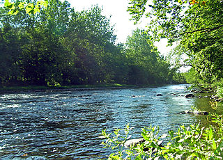
The Beaver Kill, sometimes written as the Beaverkill or Beaverkill River, is a tributary of the East Branch Delaware River, a main tributary of the Delaware River, approximately 44 miles (71 km) long, in the U.S. State of New York. The kill drains a 300-square-mile (780 km2) area of the Catskill Mountains and has long been celebrated as one of the most famous trout streams in the United States. Its preservation helped establish many of the basic conservation principles of rivers in the United States.

The West Branch Delaware River is one of two branches that form the Delaware River. It is approximately 90 mi (144 km) long, and flows through the U.S. states of New York and Pennsylvania. It winds through a mountainous area of New York in the western Catskill Mountains for most of its course, before joining the East Branch along the northeast border of Pennsylvania with New York. Midway or so it is empounded by the Cannonsville Dam to form the Cannonsville Reservoir, both part of the New York City water supply system for delivering drinking water to the City.
The Neversink River is a 55-mile-long (89 km) tributary of the Delaware River in southeastern New York in the United States. The name of the river comes from the corruption of an Algonquian language phrase meaning "mad river."
Wickecheoke Creek is a 15.0-mile-long (24.1 km) tributary of the Delaware River in Hunterdon County, New Jersey in the United States.

The Pequest River is a 35.7-mile-long (57.5 km) tributary of the Delaware River in the Skylands Region in northwestern New Jersey in the United States.
The Jones River is a 7.5-mile-long (12.1 km) river running through Kingston, Massachusetts. The river drains about 30 square miles (78 km2), has its source in Silver Lake and drains into Kingston Bay. Land surrounding the river is 52% forested, of which 22% has been developed for residential use. There is a USGS stream gauge along 16 square miles (41 km2) of the river and it has measured the flow at 0.7 cubic feet per second (0.020 m3/s) per square mile of drainage area.

The Cannonsville Reservoir is a reservoir in the New York City water supply system in Delaware County, New York. It was formed by construction of the Cannonsville Dam on its west end, which empounded over half of the West Branch of the Delaware River. Lying on the western part of the Delaware Watershed, it is the westernmost of New York City's reservoirs. It was placed in service in 1964, and is the most recently constructed New York City-owned reservoir.

The Park River, sometimes called the Hog River, flows through and under the city of Hartford, Connecticut. Between 1940 and the 1980s, the 2.3-mile (3.7 km) river was buried by the Army Corps of Engineers to prevent the spring floods regularly caused by increased surface runoff from urban development.

The Williams River is a 27.0-mile (43.5 km) river in the U.S. state of Vermont. It is a tributary of the Connecticut River. Its watershed covers 117 square miles; land use is about 80% forested and 4% agricultural, and the upper river supports wild brook trout and brown trout.

Hopkins Pond is a small pond located at the south foot of Ragged Mountain, in the town of Andover, New Hampshire, United States. It lies at an elevation of 644 feet (196 m). The pond is part of Proctor Academy's 2,500-acre (10 km2) campus in Andover and is jointly managed by Proctor and the New Hampshire Fish and Game Department. The pond area is open to the public for non-motorized boat travel, fishing and hiking.
Tonto Creek is a 72.5-mile-long (116.7 km) stream located in the Mogollon Rim area of the state of Arizona on the north edge of the Tonto National Forest. The closest town, Payson, is 18 miles (29 km) away. Tonto Creek is a stream that flows year round, starting just below the Mogollon Rim, at the northern edge of Tonto National Forest. The creek continues its descent through the Hellsgate Wilderness area and eventually into a wide valley in the Sonoran Desert. It continues through the desert and into the Salt River within the north end of Theodore Roosevelt Lake. The facilities are maintained by Tonto National Forest division of the USDA Forest Service.
Mahantango Creek is a 2.1-mile-long (3.4 km) tributary of the Susquehanna River in Snyder and Juniata counties, Pennsylvania, in the United States. Its name comes from a Delaware Indian word meaning "where we had plenty to eat". The creek flows along the border between Snyder County and Juniata County.
The Salisbury Plain River is a 4.7-mile-long (7.6 km) river in Plymouth County, Massachusetts that flows from the city of Brockton into the towns of West Bridgewater and East Bridgewater where it joins the Matfield River, a major tributary of the Taunton River.
Trout Brook may refer to:
Trout Brook, also called Ball Brook, is a cold water tributary of the Quinapoxet River located in Holden, Massachusetts. Trout Brook is stocked with trout each spring by the Massachusetts Fisheries and Wildlife Division. As the Quinapoxet River is part of the water supply for Worcester, Massachusetts, both the Quinapoxet and all of its major tributaries including Trout Brook are monitored by the USGS for water quality.
Steele Brook is a river in Delaware County, New York. It flows into the West Branch Delaware River by Delhi. Steele Brook flows through Delhi Reservoir.
East Brook is a river in Delaware County, New York. It flows into the West Branch Delaware River by Walton, New York.
Trout Brook is a river in Delaware County, New York. It flows into Beaver Kill by Peakville.