
The Au Sable River in Michigan, United States runs approximately 138 miles (222 km) through the northern Lower Peninsula, through the towns of Grayling and Mio, and enters Lake Huron at Au Sable. It is considered one of the best brown trout fisheries east of the Rockies and has been designated a blue ribbon trout stream by the Michigan Department of Natural Resources. In French, au sable literally means "at the sand." A 1795 map calls it the Beauais River.

Shelby Charter Township, officially the Charter Township of Shelby, is a charter township and census-designated place located in Macomb County in the U.S. state of Michigan. The township, an affluent northern suburb of Detroit, is located roughly 15 miles north of the city. As of the 2000 census, the township had a total population of 65,159. The 2010 Census places the population at 73,804. Shelby Charter Township is one of the fastest growing communities in Metro Detroit.

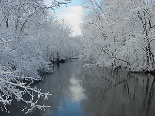
The Huron River is a 130-mile-long (210 km) river in southeastern Michigan, rising out of the Huron Swamp in Springfield Township in northern Oakland County and flowing into Lake Erie on the boundary between Wayne County and Monroe County. In addition to thirteen parks, game areas, and recreation areas, the river passes through the cities of Dexter, Ann Arbor, Ypsilanti, Belleville, Flat Rock and Rockwood.
The Paw Paw River is located in the U.S. state of Michigan in the southwest portion of the lower peninsula. It is formed by the confluence of the north and south branches at 42°15′17″N85°55′36″W in Waverly Township in the northeast of Van Buren County. It flows approximately 61.8 miles (99.5 km) through Van Buren County and Berrien County until joining the St. Joseph River just above its mouth on Lake Michigan at Benton Harbor.

Pine River may refer to any of the following streams in the U.S. state of Michigan:
- Pine River. The main branch forms with the confluence of the East and West Branches of the Pine River at 44°29′38″N83°23′16″W in Alcona County. The South Branch joins approximately 1.5 miles (2.4 km) to the south and flows into Iosco County, where it empties into Van Etten Lake at 44°29′38″N83°23′16″W northwest of Oscoda.
- Pine River. The main branch is formed by the confluence of the North and Middle Branches northeast of Standish and flows into the Saginaw Bay of Lake Huron at 43°58′32″N83°51′16″W. The South Branch Pine River joins the main stream at 43°59′08″N83°53′17″W.
- Pine River is a short waterway, which along with Round Lake, connects Lake Charlevoix with Lake Michigan at Charlevoix.
- Pine River rises in Chippewa County and flows south through Mackinac County into the St. Martin Bay of Lake Huron at 46°03′09″N84°39′22″W The North Pine River, also known as the North Branch Pine River, joins at 46°12′20″N84°36′17″W. Another tributary, Hemlock Creek, is also known as Pine River.
- Pine River, also known as the South Branch Manistee River, rises in southeast Wexford County, flows southwest across northwest Osceola County, then west and north through the northeast corner of Lake County and back into southwest Wexford County, emptying into the Tippy Dam Pond on the Manistee River at 44°13′37″N85°54′27″W. The main stream is formed from the confluence of the East Branch Pine River with the North Branch Pine River at 44°06′02″N85°31′40″W. Another tributary, the Spaulding Creek, is also known as the Little Pine River
- Pine River, in Marquette County, is a very short stream draining Pine Lake into Lake Superior at 46°53′27″N87°52′13″W, north of the Huron Mountains.
- Pine River rises in from Pine Lake in eastern Mecosta County, flows mostly south and east through Isabella County, then south along eastern edge of Montcalm County, then east and north through Gratiot County and Midland County, emptying into the Chippewa River at 43°36′06″N84°17′33″W, just about two miles before it joins the Tittabawassee River near Midland. The South Branch Pine River joins the main stream at 43°30′37″N85°00′02″W Another tributary, Miller Creek, is also sometimes known as Pine River or the West Branch Pine River. The North Branch Pine River joins the main stream at 43°26′03″N84°50′18″W.
- Pine River empties into the St. Clair River at 42°49′13″N82°29′08″W on the south side of St. Clair. The South Branch Pine River joins the main stream at 42°58′11″N82°37′10″W. Another tributary, Quakenbush Drain, is also sometimes known as Pine River.
- Pine Creek empties into Lake Superior and is also known as the Pine River.

The Jarbidge River is a 51.8-mile-long (83.4 km), high elevation river in northern Nevada and southwest Idaho in the United States. The Jarbidge originates as two main forks in the Jarbidge Mountains of northeastern Nevada and then flows through basalt and rhyolite canyons on the high plateau of the Owyhee Desert before joining the Bruneau River.

The Dowagiac River is a southwesterly flowing 30.9-mile-long (49.7 km) stream in the Lower Peninsula of the U.S. state of Michigan. It is tributary to the St. Joseph River which flows, in turn, into eastern Lake Michigan.

The Shiawassee River in the U.S. state of Michigan drains an area of 1,201 square miles (3,110 km2) within Oakland, Genesee, Livingston, Shiawassee, Midland and Saginaw counties. It flows in a generally northerly direction for about 110 miles (180 km) from its source to its confluence with the Tittabawassee River creating the Saginaw River, which drains into the Saginaw Bay of Lake Huron.

The Brule River is a 52.3-mile-long (84.2 km) river in the U.S. states of Michigan and Wisconsin. Nearly the entire course forms a portion of the boundary between the two states.
The Trout River is a 20-mile-long (32 km) tributary of the St. Johns River in Duval County, Florida. Located entirely within Jacksonville, the river is brackish in its lower section. The widest point of the river is near the St. Johns River, where it is 0.6 miles (1.0 km) across. The Trout River has wetlands as far as the mouth of the river's longest tributary, the Ribault River.
Cedar Creek may refer to several small streams in the U.S. state of Michigan:
Paint River is a 45.5-mile-long (73.2 km) river in the U.S. state of Michigan.

The Ocqueoc River is stream in Presque Isle County in the northeastern part of the lower peninsula in the U.S. state of Michigan. It is 34.2 miles (55.0 km) long and encompasses a watershed of approximately 94,394 acres (382.00 km2).

Indian River is a 59.1-mile-long (95.1 km) tributary of the Manistique River on the Upper Peninsula of Michigan in the United States. It rises out of Hovey Lake at 46°17′36″N86°42′20″W on Hiawatha National Forest land in Alger County and flows south and east through a lake district and on through Schoolcraft County. The river flows into the 8,659 acre (35 km²) Indian Lake at 46°17′36″N86°42′20″W and flows out at 45°59′30″N86°17′15″W. It then flows east and south about 2.5 miles where it merges with the Manistique River, which then flows through Manistique and into Lake Michigan at 45°56′56″N86°14′45″W.

Paint Creek Trail is an 8.9-mile (14.3 km) rail trail linear park in northeast Oakland County, Michigan. The course of the park generally follows Paint Creek, a stream that flows southeast towards the Clinton River.
Kensington was a village in Oakland County, Michigan that suffered population loss when the railroad diverted the Detroit to Lansing traffic southward to South Lyon, Michigan. It was later entirely wiped out by the building of I-96 and Kensington Metropark. The State of Michigan still recognizes the location as an unincorporated community at Grand River Avenue on Kent Lake.
Paint Creek is a stream located in the counties of Washtenaw and Monroe in Southeastern Michigan. It is a tributary of Stony Creek.


