Trzy Chałupy, Trzebnica County

Last updated
Trzy Chałupy
Village
Poland adm location map.svg
Red pog.svg
Trzy Chałupy
Coordinates: 51°20′20″N17°04′15″E / 51.33889°N 17.07083°E / 51.33889; 17.07083
Country Flag of Poland.svg  Poland
Voivodeship Lower Silesian
County Trzebnica
Gmina Trzebnica

Trzy Chałupy [ˈtʂɨ xaˈwupɨ] is a village in the administrative district of Gmina Trzebnica, within Trzebnica County, Lower Silesian Voivodeship, in south-western Poland. [1] Prior to 1945 it was in Germany.

Gmina Trzebnica is an urban-rural gmina in Trzebnica County, Lower Silesian Voivodeship, in south-western Poland. Its seat is the town of Trzebnica, which lies approximately 20 kilometres (12 mi) north of the regional capital Wrocław.

Trzebnica County County in Lower Silesian, Poland

Trzebnica County is a unit of territorial administration and local government (powiat) in Lower Silesian Voivodeship, south-western Poland. It came into being on January 1, 1999, as a result of the Polish local government reforms passed in 1998. The county covers an area of 1,025.5 square kilometres (395.9 sq mi). Its administrative seat is Trzebnica, and it also contains the towns of Oborniki Śląskie, Żmigród and Prusice.

Lower Silesian Voivodeship Voivodeship in Poland

Lower Silesian Voivodeship, or Lower Silesia Province, in southwestern Poland, is one of the 16 voivodeships (provinces) into which Poland is divided.

It lies approximately 4 kilometres (2 mi) north of Trzebnica, and 24 kilometres (15 mi) north of the regional capital Wrocław.

Wrocław Place in Lower Silesian Voivodeship, Poland

Wrocław is a city in western Poland and the largest city in the historical region of Silesia. It lies on the banks of the River Oder in the Silesian Lowlands of Central Europe, roughly 350 kilometres (220 mi) from the Baltic Sea to the north and 40 kilometres (25 mi) from the Sudeten Mountains to the south. The population of Wrocław in 2018 was 639,258, making it the fourth-largest city in Poland and the main city of Wrocław agglomeration.

Related Research Articles

Brzeźno, Lower Silesian Voivodeship Village in Lower Silesian, Poland

Brzeźno is a village in the administrative district of Gmina Prusice, within Trzebnica County, Lower Silesian Voivodeship, in south-western Poland.

Kaszyce Wielkie Village in Lower Silesian, Poland

Kaszyce Wielkie is a village in the administrative district of Gmina Prusice, within Trzebnica County, Lower Silesian Voivodeship, in south-western Poland. Prior to 1945 it was in Germany.

Biedaszków Wielki Village in Lower Silesian, Poland

Biedaszków Wielki is a village in the administrative district of Gmina Trzebnica, within Trzebnica County, Lower Silesian Voivodeship, in south-western Poland. Prior to 1945 it was in Germany.

Boleścin, Trzebnica County Village in Lower Silesian, Poland

Boleścin is a village in the administrative district of Gmina Trzebnica, within Trzebnica County, Lower Silesian Voivodeship, in south-western Poland. Prior to 1945 it was in Germany.

Domanowice Village in Lower Silesian, Poland

Domanowice is a village in the administrative district of Gmina Trzebnica, within Trzebnica County, Lower Silesian Voivodeship, in south-western Poland. Prior to 1945 it was in Germany.

Głuchów Górny Village in Lower Silesian, Poland

Głuchów Górny is a village in the administrative district of Gmina Trzebnica, within Trzebnica County, Lower Silesian Voivodeship, in south-western Poland. Prior to 1945 it was in Germany.

Jaszyce Village in Lower Silesian, Poland

Jaszyce is a village in the administrative district of Gmina Trzebnica, within Trzebnica County, Lower Silesian Voivodeship, in south-western Poland. Prior to 1945 it was in Germany.

Jaźwiny, Lower Silesian Voivodeship Village in Lower Silesian, Poland

Jaźwiny is a village in the administrative district of Gmina Trzebnica, within Trzebnica County, Lower Silesian Voivodeship, in south-western Poland. Prior to 1945 it was in Germany.

Kobylice, Lower Silesian Voivodeship Village in Lower Silesian, Poland

Kobylice is a village in the administrative district of Gmina Trzebnica, within Trzebnica County, Lower Silesian Voivodeship, in south-western Poland. Before 1945 it was in Germany.

Komorowo, Lower Silesian Voivodeship Village in Lower Silesian, Poland

Komorowo is a village in the administrative district of Gmina Trzebnica, within Trzebnica County, Lower Silesian Voivodeship, in south-western Poland. Prior to 1945 it was in Germany.

Skoroszów, Lower Silesian Voivodeship Village in Lower Silesian, Poland

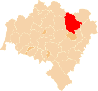
Skoroszów is a village in the administrative district of Gmina Trzebnica, within Trzebnica County, Lower Silesian Voivodeship, in south-western Poland. Prior to 1945 it was in Germany. It lies approximately 15 kilometres (9 mi) north-east of Trzebnica and 33 km (21 mi) north of the regional capital Wrocław.

Ujeździec Mały Village in Lower Silesian, Poland

Ujeździec Mały is a village in the administrative district of Gmina Trzebnica, within Trzebnica County, Lower Silesian Voivodeship, in south-western Poland. Prior to 1945 it was in Germany.

Bukowiec, Trzebnica County Village in Lower Silesian, Poland

Bukowiec is a village in the administrative district of Gmina Trzebnica, within Trzebnica County, Lower Silesian Voivodeship, in south-western Poland. Prior to 1945 it was in Germany.

Janiszów, Trzebnica County Village in Lower Silesian, Poland

Janiszów is a village in the administrative district of Gmina Trzebnica, within Trzebnica County, Lower Silesian Voivodeship, in south-western Poland. Prior to 1945 it was in Germany.

Czachowo, Lower Silesian Voivodeship Village in Lower Silesian, Poland

Czachowo is a village in the administrative district of Gmina Zawonia, within Trzebnica County, Lower Silesian Voivodeship, in south-western Poland.

Czeszów Village in Lower Silesian, Poland

Czeszów is a village in the administrative district of Gmina Zawonia, within Trzebnica County, Lower Silesian Voivodeship, in south-western Poland.

Kałowice Village in Lower Silesian, Poland

Kałowice is a village in the administrative district of Gmina Zawonia, within Trzebnica County, Lower Silesian Voivodeship, in south-western Poland. Prior to 1945 it was in Germany.

Kaszyce Milickie Village in Lower Silesian, Poland

Kaszyce Milickie is a village in the administrative district of Gmina Żmigród, within Trzebnica County, Lower Silesian Voivodeship, in south-western Poland. Prior to 1945 it was in Germany.

Koniowo Village in Lower Silesian, Poland

Koniowo is a village in the administrative district of Gmina Trzebnica, within Trzebnica County, Lower Silesian Voivodeship, in south-western Poland. Prior to 1945 it was in Germany.

Matyniów Village in Świętokrzyskie, Poland

Matyniów is a village in the administrative district of Gmina Smyków, within Końskie County, Świętokrzyskie Voivodeship, in south-central Poland. It lies approximately 3 kilometres (2 mi) north of Smyków, 15 km (9 mi) south of Końskie, and 26 km (16 mi) north-west of the regional capital Kielce.

References

Coordinates: 51°20′20″N17°04′15″E / 51.33889°N 17.07083°E / 51.33889; 17.07083

Geographic coordinate system Coordinate system

A geographic coordinate system is a coordinate system that enables every location on Earth to be specified by a set of numbers, letters or symbols. The coordinates are often chosen such that one of the numbers represents a vertical position and two or three of the numbers represent a horizontal position; alternatively, a geographic position may be expressed in a combined three-dimensional Cartesian vector. A common choice of coordinates is latitude, longitude and elevation. To specify a location on a plane requires a map projection.