Tsandi

Last updated
Tsandi
Village
Namibia location map.svg
Red pog.svg
Tsandi
Location in Namibia
Coordinates: 17°45′S14°53′E / 17.750°S 14.883°E / -17.750; 14.883
CountryFlag of Namibia.svg  Namibia
Region Omusati Region
Constituency Tsandi
Government
  TypeVillage council
Time zone UTC+2 (SAST)
[1]

Tsandi (Oshiwambo: that which is at the center) is a village in the Omusati Region of northern Namibia and the district capital of the Tsandi electoral constituency. It is a former mission station of the Finnish Missionary Society. It is situated on the main road MR123 (Outapi - Tsandi - Okahao).

Contents

Tsandi is the residential place of the Uukwaluudhi royal homestead. [2] It is also the trade center for the whole constituency and one of the oldest villages in the Uukwaluudhi kingdom. Tsandi Lodge is 2.5 kilometres (1.6 mi) away from the town in the direction of Outapi. [3]

Politics

Tsandi is governed by a village council that has five seats. [4] Omusati Region, to which Tsandi belongs, is a stronghold of Namibia's ruling SWAPO party. For the 2015 local authority election no opposition party nominated a candidate, and SWAPO won all five seats uncontested. [5]

SWAPO also won the 2020 local authority election. It obtained 261 votes and gained four seats. The Independent Patriots for Change (IPC), an opposition party formed in August 2020, obtained 72 votes and gained the remaining seat. [6]

History

The Finnish missionaries, who arrived in Ovamboland in 1870, visited the west of the area towards the end of the following year, visiting e.g. Uukwaluudhi, but the visit to that tribe did not have any tangible results at the time. [7]

In 1909, the leadership of the Finnish Missionary Society in Finland considered that missionary work should be begun also in the west of Ovamboland, and in particular among the Uukwaluudhi tribe. The local head of the mission, Martti Rautanen, together with some of his colleagues, went in July and August 1909 to Uukwaluudhi to select a site for a new mission station. They chose a place called Tsandi, and a month later the missionary August Hänninen began the construction work at the site.

The Finns came to the site at the invitation of King Iita, but he died already at the end of the same year. However, his successor Mwala Nashilongo was also friendly with the Finns, and likewise his people, too. They were not suspicious of the Finns, and the locals turned to them when they were ill. However, they did not show much interest to the preaching activities, and the local congregation consisted mainly of people who have moved there from Ondonga. The first local to be baptized in 1912 was an Uukwaluudhi man, and his three children were also baptized at the same time. The total number of people baptized on that day was 12. [8]

Hänninen soon noticed that conducting divine services and running a school outside, under a local tree, was difficult, so he encouraged his congregation members to build a proper church, built of bricks. Hänninen himself promised to acquire nails and other items and windows for the building, and teacher Aini Packalén promised to pay for the door, and the parish members made the bricks. Each man produced 500 bricks. The construction work was carried out during the cold season of 1912, and at the beginning of August, the building was completed. Its inauguration was attended to by people from all neighbouring tribes. [9]

Hänninen also went on preaching trips to the neighbouring tribe of Uukolonkadhi, and he was also asked to visit the tribe of Ombalantu. And auxiliary mission was founded in Uukolonkadhi, in the care of an ardent teacher and evangelist from Ongandjera, Abraham Iintamba. [10]

In 1922, Aatu Järvinen, a new missionary, came to Tsandi. Before the First World War he had attended a course of tropical diseases in Tübingen, Germany. He founded the clinic of Tsandi. [11]

During the 1930s, the missionary Sulo Aarni worked in Tsandi. His wife was the above-mentioned Aini Packalén. He made trips to the Kaokoveld, nearly 100 miles to the west, to visit the Hereros who lived there. [12]

Related Research Articles

<span class="mw-page-title-main">Omusati Region</span> Region in Namibia

Omusati is one of the fourteen regions of Namibia, its capital is Outapi. The towns of Okahao, Oshikuku and Ruacana as well as the self-governed village Tsandi are situated in this region. As of 2020, Omusati had 148,834 registered voters.

<span class="mw-page-title-main">Grootfontein</span> City in the Otjozondjupa Region of central Namibia

Grootfontein is a town with 23,793 inhabitants in the Otjozondjupa Region of central Namibia. It is one of the three towns in the Otavi Triangle, situated on the B8 national road that leads from Otavi to the Caprivi Strip.

<span class="mw-page-title-main">Ondangwa</span> Town in Oshana Region, Namibia

Ondangwa is a town in the Oshana Region of northern Namibia, bordering the Oshikoto Region. Ondangwa was first established as a mission station of the Finnish Missionary Society in 1890. In 1914, it became a local seat of government.

<span class="mw-page-title-main">Outapi</span> Town in northern Namibia

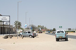
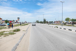
Outapi wa Nakafingo na Temba, also Outapi or Uutapi and Ombalantu, is a town in northern Namibia near the border with Angola, situated 90 km (56 mi) northwest of Oshakati. It is the capital of the Omusati region and the district capital of the Outapi electoral constituency. The language spoken there is Oshiwambo.

Eenhana is the capital town of the Ohangwena Region, northern Namibia, on the border with Angola. It also used to be a mission station of the Finnish Missionary Society.

<span class="mw-page-title-main">Ongwediva</span> Town in Oshana Region, Namibia

Ongwediva is a town in the Oshana Region in the north of Namibia. It is the district capital of the Ongwediva electoral constituency. As of 2010 it had 27,000 inhabitants and covered 4,102 hectares of land. Ongwediva has seven churches, two private schools and 13 government-run schools. Most of the inhabitants speak Oshiwambo.

Nkurenkuru is a town on the south-western banks of the Kavango River. It is the capital of the Kavango West Region of northern Namibia, located 140 kilometres (87 mi) west of Rundu. It is also a former mission station of the Finnish Missionary Society.

<span class="mw-page-title-main">Oshikuku</span> Town in Omusati Region, Namibia

Oshikuku is a town in Omusati Region in the north of Namibia. It is the district capital of Oshikuku Constituency.

Okahao is a town in the Omusati Region of northern Namibia and the district capital of the Okahao electoral constituency which is the largest constituency in Omusati region in terms of area. It is situated in the Ongandjera tribal area 73 kilometres (45 mi) west of Oshakati on the main road MR123. It is a former mission station of the Finnish Missionary Society.

<span class="mw-page-title-main">Martti Rautanen</span>

Martti (Martin) Rautanen was the pioneer of the Finnish Mission in Ovamboland, South West Africa.

Karl Emil Liljeblad was a Finnish pastor, vicar, missionary and educator, and during his final years, a researcher in Folkloristics.

<span class="mw-page-title-main">Finnish Evangelical Lutheran Mission</span> Finnish Lutheran missionary society

The Finnish Evangelical Lutheran Mission is a Lutheran missionary society formed on January 19, 1859, in Helsinki, Finland. It is one of seven organisations of the Evangelical Lutheran Church of Finland (ELCF) that conduct missionary work. Its first deployments outside Finland were made to Ovamboland, an area that today is cut by the Angola-Namibian border.

Nakayale, also known as Nakayale Keengulu is a village in northern Namibia near Outapi in Omusati Region situated 86km northwest of Oshakati and 4km from Outapi. It is in Anamulenge Constituency.

Omandongo is a populated place in the Onayena Constituency in the Oshikoto Region in northern Namibia, and the region which used to be called Ovamboland.

Engela is an Ovambo settlement in the Ohangwena Region in northern Namibia. Formerly situated in the Oukwanyama area it is since 2004 part of the town Helao Nafidi, although it still maintained its own village council until the 2015 local authority election. It is one of the more important establishments of the Evangelical Lutheran Church in Namibia (ELCIN) in the area. It started as a mission station of the Finnish Missionary Society. Today, it is the centre of the Engela Constituency.

Anamulenge is a settlement and former Catholic mission station in the Omusati Region in the north of Namibia in the Ombalantu tribal area. It is the centre of the Anamulenge Constituency.

Simson Teteinge Haivela Shituwa was one of the first seven Ovambo pastors, whom the director of the Finnish Missionary Society, Matti Tarkkanen ordained into priesthood in Oniipa, Ovamboland, on 27 September 1925, with a permission granted by the Bishop of Tampere, Jaakko Gummerus.

Nangombe Sakeus Iihuhua was one of the first seven Ovambo pastors, whom the director of the Finnish Missionary Society, Matti Tarkkanen ordained into priesthood in Oniipa, Ovamboland, on 27 September 1925, with a permission granted by the Bishop of Tampere, Jaakko Gummerus. His brother Obadja Iihuhua was also ordained at the same time.

Uushunga Obadja Iihuhua was one of the first seven Ovambo pastors, whom the director of the Finnish Missionary Society, Matti Tarkkanen ordained into priesthood in Oniipa, Ovamboland, on 27 September 1925, with a permission granted by the Bishop of Tampere, Jaakko Gummerus. His brother Sakeus Iihuhua was also ordained at the same time.

<span class="mw-page-title-main">2015 Namibian local and regional elections</span> Elections in Namibia

Namibia held elections for their local and regional councils on 27 November 2015. Ballots were cast using electronic voting.

References

Notes

  1. Tsandi Map — Satellite Images of Tsandi
  2. NACOBTA Trust entry for the Uukwaluudhi Royal Homestead Archived 2009-11-15 at the Wayback Machine
  3. Tsandi lodge, last accessed 15 April 2016
  4. "Know Your Local Authority". Election Watch. No. 3. Institute for Public Policy Research. 2015. p. 4.
  5. "Local elections results". Electoral Commission of Namibia. 28 November 2015. p. 6. Archived from the original on 10 December 2015.
  6. "2020 Local Authority Elections Results and Allocation of Seats" (PDF). Electoral Commission of Namibia. 29 November 2020. p. 13. Retrieved 25 January 2021.
  7. Peltola 1958, s. 49.
  8. Peltola 1958, s. 150–151.
  9. Peltola 1958, s. 166.
  10. Peltola 1958, s. 150–151.
  11. Peltola 1958, s. 191.
  12. Peltola 1958, s. 232.

Literature

17°45′S14°53′E / 17.750°S 14.883°E / -17.750; 14.883