
Dartmouth Dam is a large rock-fill embankment dam with an uncontrolled chute spillway across the Mitta Mitta, Gibbo, and Dart rivers, the Morass Creek and a number of small tributaries. The dam is located near Mount Bogong in the north-east of the Australian state of Victoria. The dam's purpose includes irrigation, the generation of hydro-electric power, water supply and conservation. The impounded reservoir is called Dartmouth Reservoir, sometimes called Lake Dartmouth. The Dartmouth Power Station, a hydro-electric power station that generates power to the national grid, is located near the dam wall.
The Gardiner Dam on the South Saskatchewan River in Saskatchewan is the third largest embankment dam in Canada and one of the largest embankment dams in the world. Construction on Gardiner Dam and the smaller Qu'Appelle River Dam was started in 1959 and completed in 1967, creating Lake Diefenbaker upstream and diverting a considerable portion of the South Saskatchewan's flow into the Qu'Appelle River. The dam rises 64 metres (209 feet) in height, is almost 5 km (3.1 mi) long and has a width of 1.5 km (0.93 mi) at its base with a volume of 65,000,000 cubic meters. The dam is owned and operated by the Saskatchewan Water Security Agency.
The Salt River Project (SRP) is the umbrella name for two separate entities: the Salt River Project Agricultural Improvement and Power District, an agency of the state of Arizona that serves as an electrical utility for the Phoenix metropolitan area, and the Salt River Valley Water Users' Association, a utility cooperative that serves as the primary water provider for much of central Arizona. It is one of the primary public utility companies in Arizona.

GandhisagarDam is situated at a distance of 168 km from the District headquarter. The Dam is constructed on the Chambal River.

Hirakud Dam is built across the Mahanadi River, about 15 kilometres (9 mi) from Sambalpur in the state of Odisha in India. It is the longest earthen dam in the world. Behind the dam extends a lake, Hirakud Reservoir, 55 km (34 mi) long. It is one of the first major multipurpose river valley projects started after India's independence. Hirakud Reservoir was declared a Ramsar site on 12 October 2021.

Maharana Pratap Sagar, also known as Pong Reservoir or Pong Dam Lake is a large reservoir in Fatehpur, Jawali and Dehra tehsil of Kangra district of the state of Himachal Pradesh in India. It was created in 1975, by building the highest earthfill dam in India on the Beas River in the wetland zone of the Siwalik Hills. Named in the honour of Maharana Pratap (1540–1597), the reservoir or the lake is a well-known wildlife sanctuary and one of the 49 international wetland sites declared in India by the Ramsar Convention. The reservoir covers an area of 24,529 hectares, and the wetlands portion is 15,662 hectares.

Lake Qaraoun is an artificial lake or reservoir located in the southern region of the Beqaa Valley, Lebanon. It was created near Qaraoun village in 1959 by building a 61 m-high (200 ft) concrete-faced rockfill dam in the middle reaches of the Litani River. The reservoir has been used for hydropower generation, domestic water supply, and for irrigation of 27,500 ha.

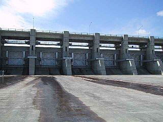
New Exchequer Dam is a concrete–faced, rock-fill dam on the Merced River in central California in the United States. It forms Lake McClure, which impounds the river for irrigation and hydroelectric power production and has a capacity of more than 1,000,000 acre-feet (1.2 km3). The Merced Irrigation District (MID) operates the dam and was also responsible for its construction.

The Daniel-Johnson dam, formerly known as Manic-5, is a multiple-arch buttress dam on the Manicouagan River that creates the annular Manicouagan Reservoir. The dam is composed of 14 buttresses and 13 arches and is 214 km (133 mi) north of Baie-Comeau in Quebec, Canada. The dam was constructed between 1959 and 1970 for the purpose of hydroelectric power production and supplies water to the Manic-5 and Manic-5-PA power houses with a combined capacity of 2,660 MW. The dam is 214 m (702 ft) tall, 1,314 m (4,311 ft) long and contains 2,200,000 m3 of concrete, making it the largest dam of its type in the world.

The Mingtan Dam is a dam that spans the Shuili River about 4 km (2.5 mi) downstream from the outlet of Sun Moon Lake in central Taiwan with a height of about 61.5 m (202 ft). It forms Mingtan Reservoir which is the lower reservoir for the Mingtan Pumped Storage Hydro Power Plant.

The Pensacola Dam, also known as the Grand River Dam, is a multiple-arch buttress dam located between the towns of Disney and Langley on the Grand River in Mayes County, Oklahoma. The dam is operated by the Grand River Dam Authority and creates Grand Lake o' the Cherokees. After decades of vision and planning, it was constructed between 1938 and 1940 for the purposes of hydroelectric power generation, flood control and recreation. It is Oklahoma's first hydroelectric power plant and is referred to as the longest multiple-arch dam in the world.
The Koteshwar Dam is a gravity dam on the Bhagirathi River, located 22 km (14 mi) downstream of the Tehri Dam in Tehri District, Uttarakhand, India. The dam is part of the Tehri Hydropower Complex and serves to regulate the Tehri Dam's tailrace for irrigation and create the lower reservoir of the Tehri Pumped Storage Power Station. In addition, the dam has a 400 MW run-of-the-river power station. The project was approved in 2000 and its first generator was commissioned on 27 March 2011, the second on 30 March 2011. The construction site had been inundated in September 2010 by floods. The diversion tunnel was later blocked heaving/collapse of the hill in December 2010. The spillway was commissioned in Jan, 2011. The last two generators were made operational in March 2012.
The Hunanzhen Dam is a trapezoidal buttress dam on the Qiantang River, located 27 km (17 mi) south of Quzhou in Zhejiang Province, China. The primary purpose of the dam is hydroelectric power generation but it also serves to provide for flood control and irrigation water supply. Construction on the dam began in 1958 but was halted in 1961. It recommenced in 1970, the first generator was operational in 1979 and the project complete in 1980. The original installed capacity of the dam's power plant was 170 MW but the plant was expanded with an additional 100 MW generator, commissioned in 2006.
The Pong Dam, also known as the Beas Dam, is an earth-fill embankment dam on the Beas River in the state of Himachal Pradesh, India, just upstream of Talwara. The purpose of the dam is water storage for irrigation and hydroelectric power generation. As the second phase of the Beas Project, construction on the dam began in 1961 and was completed in 1974. At the time of its completion, the Pong Dam was the tallest of its type in India. The lake created by the dam, Maharana Pratap Sagar, became a renowned bird sanctuary.

The Roselend Dam is an arch-buttress dam located 5 km (3 mi) east of Beaufort in the Savoie department of the Rhône-Alpes region in south-eastern France. It is located just west and below the Cormet de Roselend mountain pass. The dam was designed by Coyne et Bellier and construction began in 1955. The reservoir began to fill in 1960, the power station was operational in 1961 and the dam complete in 1962. It was constructed for the primary purpose of hydroelectric power generation and supports the 546 MW La Bâthie Power Station.
Mantasoa Dam is a buttress dam on the Varahina-North River, a tributary of the Ikopa River, near Mantasoa in the Analamanga Region of Madagascar. The dam was constructed by French contractors between 1937 and 1938. It creates Lake Mantasoa which has a surface area of 20 km2 (7.7 sq mi). The dam itself is made of 8,000 m3 (10,000 cu yd) of concrete and has a reinforced buttress design. Water released from the dam supplies a regulated flow to hydroelectric power station at the Antelomita Dams downstream. A saddle dam on the north side of the Mantosoa reservoir regulates water flow into the Mandraka River for the Mandraka Dam downstream.
Mandraka Dam is a gravity dam on the Mandraka River near Mandraka in the Analamanga Region of Madagascar. The dam was constructed by a French firm by 1956 and creates Lake Mandraka.
The Antelomita Hydroelectric Power Station is located in the rural commune Anjeva Gara of the Analamanga Region, Madagascar. The hydroelectric power station comprises two parts, Antelomita I and II. Both are adjacent to one another on separate water falls along the Ikopa River. Each water fall is dammed and water is diverted to the power station; each of which contains three 1.4 megawatts (1,900 hp) generators. The first two were commissioned in 1930, the second two in 1952 and the final two in 1953. Both stages have an installed capacity of 8.4 megawatts (11,300 hp). They were built by a French firm but are now owned and operated by Jirama. The Tsiazompaniry and Mantasoa Dams upstream regulate water to the power station.

