Tsirku River

Last updated
Tsirku River
Tsirku River.JPG
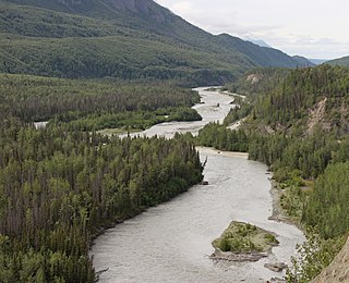
Tsirku River west of the mouth
Country United States
State Alaska
Borough Haines
Source Tsirku Glacier
 - location north slope of Takhinsha Mountains
 - elevation 1,460 ft (445 m) [1]
 - coordinates 59°17′50″N136°24′55″W / 59.29722°N 136.41528°W / 59.29722; -136.41528   [2]
Mouth Chilkat River
 - location Klukwan, 21 miles (34 km) southwest of Skagway, St. Elias Mountains
 - elevation 56 ft (17 m) [2]
 - coordinates 59°23′26″N135°52′12″W / 59.39056°N 135.87000°W / 59.39056; -135.87000 Coordinates: 59°23′26″N135°52′12″W / 59.39056°N 135.87000°W / 59.39056; -135.87000   [2]
Length 25 mi (40 km) [3]
USA Alaska location map.svg
Red pog.svg
Location of the mouth of the Tsirku River in Alaska

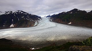
The Tsirku River is a glacier-fed stream in Southeast Alaska near the town of Haines in the U.S. state of Alaska. The river's source is found at the Tsirku Glacier, a large, sprawling ice mass at the border of Alaska and the Canadian province of British Columbia. The river ends in a 4-mile (6 km) wide delta near the Tlingit village of Klukwan. While many of the feeding glaciers are primarily in British Columbia, the river course lies entirely in Alaska.

Haines, Alaska Census-designated place in Alaska, United States

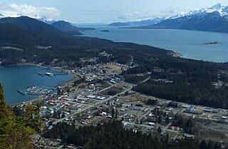
Haines is a census-designated place located in Haines Borough, Alaska, United States. It is in the northern part of the Alaska Panhandle, near Glacier Bay National Park and Preserve.

U.S. state constituent political entity of the United States

In the United States, a state is a constituent political entity, of which there are currently 50. Bound together in a political union, each state holds governmental jurisdiction over a separate and defined geographic territory and shares its sovereignty with the federal government. Due to this shared sovereignty, Americans are citizens both of the federal republic and of the state in which they reside. State citizenship and residency are flexible, and no government approval is required to move between states, except for persons restricted by certain types of court orders. Four states use the term commonwealth rather than state in their full official names.

Alaska State of the United States of America

Alaska is a U.S. state in the northwest extremity of North America, just across the Bering Strait from Asia. The Canadian province of British Columbia and territory of Yukon border the state to the east, its most extreme western part is Attu Island, and it has a maritime border with Russia to the west across the Bering Strait. To the north are the Chukchi and Beaufort seas—southern parts of the Arctic Ocean. The Pacific Ocean lies to the south and southwest. It is the largest U.S. state by area and the seventh largest subnational division in the world. In addition, it is the 3rd least populous and the most sparsely populated of the 50 United States; nevertheless, it is by far the most populous territory located mostly north of the 60th parallel in North America: its population—estimated at 738,432 by the United States Census Bureau in 2015— is more than quadruple the combined populations of Northern Canada and Greenland. Approximately half of Alaska's residents live within the Anchorage metropolitan area. Alaska's economy is dominated by the fishing, natural gas, and oil industries, resources which it has in abundance. Military bases and tourism are also a significant part of the economy.

After the Klehini River, the Tsirku River is the second largest tributary of the Chilkat River.

Klehini River river

The Klehini River is a large, glacially fed stream in the vicinity of Haines in the U.S. state of Alaska.

Chilkat River river

The Chilkat River is a river in British Columbia and southeastern Alaska that flows southward from the Coast Range to the Chilkat Inlet and ultimately Lynn Canal. It is about 80 kilometres (50 mi) long. It begins at Chilkat Glacier, in Alaska, flows west and south in British Columbia for 27 kilometres (17 mi), enters Alaska and continues southwest for another 60 kilometres (37 mi). It reaches the ocean at the abandoned area of Wells, Alaska and deposits into a long delta area.

See also

Related Research Articles

Continental Divide of the Americas principal hydrological divide of North and South America

The Continental Divide is the principal, and largely mountainous, hydrological divide of the Americas. The Continental Divide extends from the Bering Strait to the Strait of Magellan, and separates the watersheds that drain into the Pacific Ocean from those river systems that drain into the Atlantic Ocean and, along the northernmost reaches of the Divide, those river systems that drain into the Arctic Ocean.

Pacific Coast Ranges

ThePacific Coast Ranges, are the series of mountain ranges that stretch along the West Coast of North America from Alaska south to Northern and Central Mexico.

Chugach Mountains

The Chugach Mountains of southern Alaska are the northernmost of the several mountain ranges that make up the Pacific Coast Ranges of the western edge of North America. The range is about 250 miles (402 km) long and 60 miles (97 km) wide, and extends from the Knik and Turnagain Arms of the Cook Inlet on the west to Bering Glacier, Tana Glacier, and the Tana River on the east. It is bounded on the north by the Matanuska, Copper, and Chitina rivers. The highest point of the Chugach Mountains is Mount Marcus Baker, at 13,094 feet (3,991 m), but with an average elevation of 4,006 feet (1,221 m), most of its summits are not especially high. Even so its position along the Gulf of Alaska ensures more snowfall in the Chugach than anywhere else in the world, an annual average of over 1500 cm (800 in).

Mount Hubbard mountain

Mount Hubbard is one of the major mountains of the Saint Elias Range. It is located on the Alaska/Yukon border; the Canadian side is within Kluane National Park and Reserve, and the American side is part of Wrangell–St. Elias National Park. The mountain was named in 1890 by U.S. Geological Survey geologist Israel Russell after Gardiner Greene Hubbard, first president of the National Geographic Society, which had co-sponsored Russell's expedition.

Copper River (Alaska) river in the United States of America

The Copper River or Ahtna River, Ahtna Athabascan ‘Atna’tuu, "river of the Ahtnas", Tlingit Eeḵhéeni, "river of copper", is a 290-mile (470 km) river in south-central Alaska in the United States. It drains a large region of the Wrangell Mountains and Chugach Mountains into the Gulf of Alaska. It is known for its extensive delta ecosystem, as well as for its prolific runs of wild salmon, which are among the most highly prized stocks in the world. The river is the tenth largest in the United States, as ranked by average discharge volume at its mouth.

Stikine River

The Stikine River is a river, historically also the Stickeen River, approximately 610 km (379 mi) long, in northwestern British Columbia in Canada and in southeast Alaska in the United States.

Matanuska River river in the United States of America

The Matanuska River is a 75-mile (121 km) long stream in Southcentral Alaska, United States. The river drains a broad valley south of the Alaska Range eponymously known as the Matanuska Valley.

Selkirk Mountains mountain range

The Selkirk Mountains are a mountain range spanning the northern portion of the Idaho Panhandle, eastern Washington, and southeastern British Columbia which are part of a larger grouping of mountains, the Columbia Mountains. They begin at Mica Peak near Spokane and extend approximately 320 km north from the border to Kinbasket Lake, at the now-inundated location of the onetime fur company post Boat Encampment. The range is bounded on its west, northeast and at its northern extremity by the Columbia River, or the reservoir lakes now filling most of that river's course. From the Columbia's confluence with the Beaver River, they are bounded on their east by the Purcell Trench, which contains the Beaver River, Duncan River, Duncan Lake, Kootenay Lake and the Kootenay River. The Selkirks are distinct from, and geologically older than, the Rocky Mountains. The neighboring Monashee and Purcell Mountains, and sometimes including the Cariboo Mountains to the northwest, are also part of the larger grouping of mountains known as the Columbia Mountains. A scenic highway loop, the International Selkirk Loop, encircles the southern portions of the mountain range.

Mount Sanford (Alaska) mountain

Mount Sanford is a shield volcano in the Wrangell Volcanic Field, in eastern Alaska near the Copper River. It is the sixth highest mountain in the United States and the third highest volcano behind Mount Bona and Mount Blackburn. The south face of the volcano, at the head of the Sanford Glacier, rises 8,000 feet (2,400 m) in 1 mile (1,600 m) resulting in one of the steepest gradients in North America.

Taku River

The Taku River is a river running from British Columbia, Canada, to the northwestern coast of North America, at Juneau, Alaska. The river basin spreads across 27,500 square kilometres (10,600 sq mi). The Taku is a very productive salmon river and its drainage basin is primarily wilderness.

Columbia Glacier (Washington) glacier in Washington

Columbia Glacier is a glacier located in the Henry M. Jackson Wilderness in the U.S. state of Washington. It descends from 5,600 ft (1,700 m) to 4,700 ft (1,400 m) above sea level. It is surrounded by Columbia Peak, Monte Cristo Peak, and Kyes Peak and is a source of water for Blanca Lake and Troublesome Creek, a tributary of the North Fork Skykomish River.

Carbon Glacier glacier in the United States

Carbon Glacier is located on the north slope of Mount Rainier in the U.S. state of Washington and is the source of the Carbon River. The snout at the glacier terminal moraine is at about 3,500 feet (1,100 m) above sea level, making it the lowest-elevation glacier in the contiguous United States. The glacier also has the greatest length, thickness and volume of any U.S. glacier outside of Alaska.

Salmon Glacier glacier in Canada

The Salmon Glacier is a glacier located ~25 km (16 mi) north of Stewart, British Columbia, and Hyder, Alaska, just on the Canadian side of the border. The glacier, one of hundreds in the Boundary Ranges, is notable for its major potential as a natural hazard. Summit Lake is located at the northern end of the glacier and every year around mid-July the lake breaks an ice-dam and then flows under the Salmon Glacier into the Salmon River. This causes the river to rise approximately 4–5 ft (1.2–1.5 m) for several days.

Whiting River

The Whiting River is a stream, about 50 miles (80 km) long, in the U.S. state of Alaska and the Canadian province of British Columbia. It enters the waters of Stephens Passage at the Borough of Juneau in the Alaska Panhandle between the mouths of the Taku and Stikine Rivers. The main tributary of the Whiting is the South Whiting. The river's basin is at the northern end of the Stikine Icecap The river crosses the international boundary at 58°11′00″N133°13′00″W. Its origin is in the Chechidla Range, and its terminus is at Gilbert Bay, which empties into Stephens Passage. In 1888, Lieutenant Commander C. M. Thomas of the U.S. Navy (USN) named the river for assistant surgeon Robert Whiting, USN, a member of his surveying party.

White River (Yukon) river in Yukon and Alaska

The White River is a tributary about 200 miles (320 km) long, of the Yukon River in the U.S. state of Alaska and the Canadian territory of Yukon. The Alaska Highway crosses the White River near Beaver Creek.

The Tsirku Glacier is a large icefield in the Saint Elias Mountains, spanning the border between British Columbia and Alaska, to the south of the Jarvis Glacier. It is the source of the Tsirku River, which flows northwest to become the second-largest tributary of the Chilkat River. GNIS gives its head at 59°17′00″N136°47′00″W and describes it as flowing across the Canada–US border one mile west of the head of the Tsirku River.

Mount Gallatin

Mount Gallatin, also known as Boundary Peak 67, is a mountain in the Boundary Ranges along the British Columbia-Alaska border.

References

  1. Derived by entering source coordinates in Google Earth.
  2. 1 2 3 "Tsirku River". Geographic Names Information System. United States Geological Survey. January 1, 2000. Retrieved January 1, 2014.
  3. Orth, Donald J.; United States Geological Survey (1971) [1967]. Dictionary of Alaska Place Names: Geological Survey Professional Paper 567 (PDF). United States Government Printing Office. p. 988. Retrieved January 1, 2014.