Tsunami deposit

Last updated
Depositional environments in which deposits are formed associated with a tsunami Tsunami deposit environments.svg
Depositional environments in which deposits are formed associated with a tsunami

A tsunami deposit (the term tsunamiite is also sometimes used) is a sedimentary unit deposited as the result of a tsunami. Such deposits may be left onshore during the inundation phase or offshore during the 'backwash' phase. Such deposits are used to identify past tsunami events and thereby better constrain estimates of both earthquake and tsunami hazards. There remain considerable problems, however, in distinguishing between deposits caused by tsunamis and those caused by storms or other sedimentary processes.

Contents

Tsunamiite

The term "tsunamiite" or "tsunamite" was introduced in the 1980s to describe deposits interpreted to have been formed by traction processes associated with tsunamis and is particularly used for marine deposits formed during the "backwash" phase. The term's application has broadened to encompass all tsunami-related deposits, but its use has been challenged. The main criticism of the term is that it describes deposits that have formed by many different processes that are not necessarily unique to deposition related to tsunamis, [1] but it remains in use. [2]

Recognition

Onshore

Sandsheet thought to have resulted from the tsunami caused by an earthquake on January 26, 1700, river bank Oregon Cascadia 1700 tsunami layer Oregon.jpg
Sandsheet thought to have resulted from the tsunami caused by an earthquake on January 26, 1700, river bank Oregon

The deposits from well-recorded historical tsunamis can be compared with those from well-recorded storm events. In both cases, these overwash deposits are found in low-lying areas behind the coastline, such as lagoons. These depositional environments are generally characterised by slow lacustrine to swamp sedimentation, producing a sequence of fine-grained sediments. Both tsunami deposits and storm deposits may have strongly erosive bases and mainly consist of sand, often with shell fragments. The most reliable indicator of a tsunami origin appears to be the extent of the inundation, with tsunamis generally inundating further than storms on a particular coast. [3] [4] In some cases, tsunami deposits show clear separation into distinct sub-units deposited by successive tsunami waves, whereas storm waves normally show a higher number of sub-divisions. The presence of material eroded from the shelf is considered more likely to suggest a tsunami rather than a storm event due to the much greater energy and erosive power associated with individual waves in the tsunami. [5] The movement of large boulders has also been used to argue for a tsunami origin, but probably only the largest boulders represent good evidence of this as major storms, such as cyclones are known to be able to move large boulders. The amount of movement is also likely to be greater with tsunami waves due to their much longer period.[ citation needed ]

Offshore

Sediment entrained in the tsunami wave that is not deposited onshore may either settle out in the shallow water or become involved in debris flows, possibly becoming turbidity currents as velocities increase downslope. Shallow water sediments may also be influenced by major storm events, which like a tsunami, will rework sediment from around the shoreline and redeposit them within the shelf environment. Debris flows and turbidites may be formed by slope failures, which may themselves be directly triggered by the earthquake. There are as yet no unequivocal criteria available for identifying the trigger for such uncommon depositional events. [1] [6]

Use

The recognition and dating of tsunami deposits is an important part of paleoseismology. The extent of a particular deposit may help to judge the magnitude of a known historical earthquake or to act as evidence of a prehistoric event. In the case of the 869 Sanriku earthquake, the identification of tsunami deposits over 4.5 km inland on the Sendai Plain, dated quite closely to a historical tsunami event, enabled the magnitude of this earthquake to be estimated and the likely rupture area offshore located. Two earlier deposits with similar character were identified and dated. The three deposits were used to suggest a return period for large tsunamigenic earthquakes along the Sendai coast of about 1,000 years, suggesting that a repeat of this event was overdue and that large scale inundation was likely. [7] In 2007, the likelihood of a great tsunamigenic earthquake striking this coast in the next 30 years was given as 99%. [8] Based partly on this information TEPCO revised estimates of likely tsunami heights at the Fukushima Daiichi Nuclear Power Plant to greater than 9 m, but took no immediate action. [9] The tsunami triggered by the 2011 Tohoku earthquake had a wave height at Fukushima of about 15 m, well above the 5.7 m for which the plant's defences had been designed. [10] The inundation distance of the tsunami was almost identical to that reported for the three earlier events, as was the lateral extent. [11]

Related Research Articles

<span class="mw-page-title-main">Tsunami</span> Series of water waves caused by the displacement of a large volume of a body of water

A tsunami is a series of waves in a water body caused by the displacement of a large volume of water, generally in an ocean or a large lake. Earthquakes, volcanic eruptions and other underwater explosions above or below water all have the potential to generate a tsunami. Unlike normal ocean waves, which are generated by wind, or tides, which are in turn generated by the gravitational pull of the Moon and the Sun, a tsunami is generated by the displacement of water from a large event.

<span class="mw-page-title-main">Megatsunami</span> Very large wave created by a large, sudden displacement of material into a body of water

A megatsunami is a very large wave created by a large, sudden displacement of material into a body of water.

<span class="mw-page-title-main">Japan Trench</span> Oceanic trench part of the Pacific Ring of Fire off northeast Japan

The Japan Trench is an oceanic trench part of the Pacific Ring of Fire off northeast Japan. It extends from the Kuril Islands to the northern end of the Izu Islands, and is 8,046 metres (26,398 ft) at its deepest. It links the Kuril–Kamchatka Trench to the north and the Izu–Ogasawara Trench to its south with a length of 800 kilometres (497 mi). This trench is created as the oceanic Pacific plate subducts beneath the continental Okhotsk Plate. The subduction process causes bending of the down going plate, creating a deep trench. Continuing movement on the subduction zone associated with the Japan Trench is one of the main causes of tsunamis and earthquakes in northern Japan, including the megathrust Tōhoku earthquake and resulting tsunami that occurred on 11 March 2011. The rate of subduction associated with the Japan Trench has been recorded at about 7.9–9.2 centimetres (3.1–3.6 in)/yr.

<span class="mw-page-title-main">Turbidity current</span> An underwater current of usually rapidly moving, sediment-laden water moving down a slope

A turbidity current is most typically an underwater current of usually rapidly moving, sediment-laden water moving down a slope; although current research (2018) indicates that water-saturated sediment may be the primary actor in the process. Turbidity currents can also occur in other fluids besides water.

Overwash is the flow of water and sediment over a coastal dune or beach crest during storm events. 'Overwash' may refer only to the landward flux of water due to overtopping of a dune system while 'washover' may refer to the sediment deposited by overwash. A common process on barrier islands, Overwash redistributes sediment and facilitates the migration of barrier islands in response to sea level rise. Overwash can occur as a result of runup, or inundation.

<span class="mw-page-title-main">Depositional environment</span> Processes associated with the deposition of a particular type of sediment

In geology, depositional environment or sedimentary environment describes the combination of physical, chemical, and biological processes associated with the deposition of a particular type of sediment and, therefore, the rock types that will be formed after lithification, if the sediment is preserved in the rock record. In most cases, the environments associated with particular rock types or associations of rock types can be matched to existing analogues. However, the further back in geological time sediments were deposited, the more likely that direct modern analogues are not available.

<span class="mw-page-title-main">Submarine landslide</span> Landslides that transport sediment across the continental shelf and into the deep ocean

Submarine landslides are marine landslides that transport sediment across the continental shelf and into the deep ocean. A submarine landslide is initiated when the downwards driving stress exceeds the resisting stress of the seafloor slope material, causing movements along one or more concave to planar rupture surfaces. Submarine landslides take place in a variety of different settings, including planes as low as 1°, and can cause significant damage to both life and property. Recent advances have been made in understanding the nature and processes of submarine landslides through the use of sidescan sonar and other seafloor mapping technology.

<span class="mw-page-title-main">Contourite</span> Type of sedimentary deposit

A contourite is a sedimentary deposit commonly formed on continental rise to lower slope settings, although they may occur anywhere that is below storm wave base. Countourites are produced by thermohaline-induced deepwater bottom currents and may be influenced by wind or tidal forces. The geomorphology of contourite deposits is mainly influenced by the deepwater bottom-current velocity, sediment supply, and seafloor topography.

<span class="mw-page-title-main">1896 Sanriku earthquake</span> Japanese tsunami earthquake

The 1896 Sanriku earthquake was one of the most destructive seismic events in Japanese history. The 8.5 magnitude earthquake occurred at 19:32 on June 15, 1896, approximately 166 kilometres (103 mi) off the coast of Iwate Prefecture, Honshu. It resulted in two tsunami waves which destroyed about 9,000 homes and caused at least 22,000 deaths. The waves reached a then-record height of 38.2 metres (125 ft); this would remain the highest on record until waves from the 2011 Tōhoku earthquake exceeded that height by more than 2 metres.

<span class="mw-page-title-main">Canterbury Bight</span> Oceanic bight in Canterbury, New Zealand

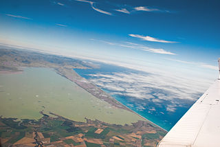
The Canterbury Bight is a large bight on the eastern side of New Zealand's South Island. The bight runs for approximately 135 kilometres (84 mi) from the southern end of Banks Peninsula to the settlement of Timaru and faces southeast, exposing it to high-energy storm waves originating in the Pacific Ocean. The bight is known for rough conditions as a result, with wave heights of over 2 metres (6.6 ft) common. Much of the bight's geography is shaped by this high-energy environment interacting with multiple large rivers which enter the Pacific in the bight, such as the Rakaia, Ashburton / Hakatere, and Rangitata Rivers. Sediment from these rivers, predominantly Greywacke, is deposited along the coast and extends up to 50 kilometres (31 mi) out to sea from the current shoreline. Multiple hapua, or river-mouth lagoons, can be found along the length of the bight where waves have deposited sufficient sediment to form a barrier across a river mouth, including most notably Lake Ellesmere / Te Waihora and Washdyke Lagoon
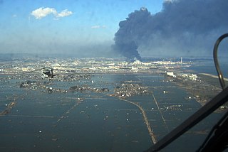
The 869 Jōgan earthquake and its associated tsunami struck the area around Sendai in the northern part of Honshu on 13 July 869. The earthquake had an estimated magnitude of at least 8.4 on the moment magnitude scale, but may have been as high as 9.0, similar to the 2011 Tōhoku earthquake and tsunami. The tsunami caused widespread flooding of the Sendai plain. In 2001, researchers identified sand deposits in a trench more than 4.5 kilometres (2.8 mi) from the coast as coming from this tsunami.

<span class="mw-page-title-main">Coastal flooding</span> Type of natural disaster

Coastal flooding occurs when dry and low-lying land is submerged (flooded) by seawater. The range of a coastal flooding is a result of the elevation of floodwater that penetrates the inland which is controlled by the topography of the coastal land exposed to flooding. The seawater can flood the land via several different paths: direct flooding, overtopping of a barrier, or breaching of a barrier. Coastal flooding is largely a natural event. Due to the effects of climate change and an increase in the population living in coastal areas, the damage caused by coastal flood events has intensified and more people are being affected.

<span class="mw-page-title-main">Tsunami earthquake</span> Type of earthquake which triggers a tsunami of far-larger magnitude

In seismology, a tsunami earthquake is an earthquake which triggers a tsunami of significantly greater magnitude, as measured by shorter-period seismic waves. The term was introduced by Japanese seismologist Hiroo Kanamori in 1972. Such events are a result of relatively slow rupture velocities. They are particularly dangerous as a large tsunami may arrive at a coastline with little or no warning.

<span class="mw-page-title-main">1983 Sea of Japan earthquake</span> 1983 earthquake and tsunami centered off the coast of Akita Prefecture, Japan

The 1983 Sea of Japan earthquake occurred on May 26, 1983 at 11:59:57 local time. It had a magnitude of 7.8 on the moment magnitude scale. It occurred in the Sea of Japan, about 100 km west of the coast of Noshiro in Akita Prefecture, Japan. Out of the 104 fatalities, all but four were killed by the resulting tsunami, which struck communities along the coast, especially Aomori and Akita Prefectures and the east coast of Noto Peninsula. Images of the tsunami hitting the fishing harbor of Wajima on Noto Peninsula were broadcast on TV. The waves exceeded 10 meters (33 ft) in some areas. Three of the fatalities were along the east coast of South Korea. The tsunami also hit Okushiri Island, the site of a more deadly tsunami 10 years later.

The 1169 Sicily earthquake occurred on 4 February 1169 at 08:00 local time on the eve of the feast of St. Agatha of Sicily. It had an estimated magnitude of between 6.4 and 7.3 and an estimated maximum perceived intensity of X (Extreme) on the Mercalli intensity scale. The cities of Catania, Lentini and Modica were severely damaged, and the earthquake also triggered a paleotsunami. Overall, the earthquake is estimated to have caused the deaths of at least 15,000 people.

The 1420 Caldera earthquake shook the southern portion of Atacama Desert in the early morning of August 31, 1420 and caused tsunamis in Chile as well as Hawaii and the towns of Japan. The earthquake is thought to have had a size of 8.8–9.4 Mw. Historical records of the tsunami exist for the Japanese harbours of Kawarago and Aiga where confused residents saw the water recede in the morning of September 1, without any sign of an earthquake. In Chile, rockfalls occurred along the coast as well, producing blocks of up to 40 tons that are now found inland. This is also consistent with the identification of a possible tsunami deposit in Mejillones Bay that has been dated to the range 1409 to 1449. Deposits found by coring of recent sediments in a wetland near Tongoy Bay have also been linked to the 1420 tsunami.

The Cotabato Trench is an oceanic trench in the Pacific Ocean, off the southwestern coast of Mindanao in the Philippines. Along this trench the oceanic crust of the Sunda Plate beneath the Celebes Sea is being subducted beneath the Philippines Mobile Belt. It forms part of a linked set of trenches along the western side of the Philippines formed over east-dipping subduction zones, including the Manila Trench and the Negros Trench. At its northern end the rate of convergence across this boundary is about 100 mm per year. It is a relatively young structure, forming during the late Miocene to Pliocene. This age is consistent with the estimated age of the sedimentary rocks in the accretionary wedge associated with the trench and the age of adakitic arc rocks on Mindanao thought to date the onset of subduction.

The Garth tsunami is a likely prehistoric tsunami off the Shetland Islands that may have occurred 5,500 years ago. Its origin is unknown; impact events, earthquakes, and submarine landslides similar to the Storegga Slide 8,100 years ago have been proposed as factors contributing to the event. Evidence suggests a run-up of more than 10 metres (33 ft) in the Shetland Islands. It probably had great impact on coastal communities in the region; mass burials dating approximately to that time in the Shetland and Orkney Islands have been interpreted to host its fatalities.

<span class="mw-page-title-main">1585 Aleutian Islands earthquake</span> 16th-century seismic event in the North Pacific Ocean

The 1585 Aleutian Islands earthquake is the presumed source of a tsunami along the Sanriku coast of Japan on 11 June 1585, known only from vague historical accounts and oral traditions. The event was initially misdated to 1586, which led to it being associated with the deadly earthquakes in Peru and Japan of that year. A megathrust earthquake on the Aleutian subduction zone in the North Pacific Ocean was hypothesized as the tsunami's source. Paleotsunami evidence from shoreline deposits and coral rocks in Hawaii suggest that the 1585 event was a large megathrust earthquake with a moment magnitude (Mw ) as large as 9.25.

A paleotsunami is a tsunami that occurs prior to written history where there are no documented observations. Paleotsunamis are evidenced by modern technology and scientific research. One of the largest was a megatsunami resulting from the asteroid that wiped out the dinosaurs.

References

  1. 1 2 Shanmugam, G. (2006). "The Tsunamite problem". Journal of Sedimentary Research. 76 (5): 718–730. Bibcode:2006JSedR..76..718S. doi:10.2110/jsr.2006.073 . Retrieved 25 November 2011.
  2. Shiki, T.; Yamazaki, T. (2008). "The term 'Tsunamiite'". In Shiki T. (ed.). Tsunamiites: features and implications. Developments in Sedimentology. Elsevier. p. 5. ISBN   978-0-444-51552-0 . Retrieved 25 November 2011.
  3. Richmond, B.M.; Watt S.; Buckley M.; Gelfenbaum G.; Morton R.A. (2011). "Recent storm and tsunami coarse-clast deposit characteristics, southeast Hawaiʻi". Marine Geology. Elsevier. 283 (1–4): 79–89. doi:10.1016/j.margeo.2010.08.001.
  4. Engel, M., Brückner, H., 2011. The identification of palaeo-tsunami deposits - a major challenge in coastal sedimentary research Archived 2012-04-26 at the Wayback Machine . In: Karius, V., Hadler, H., Deicke, M., von Eynatten, H., Brückner, H., Vött, A. (eds.), Dynamische Küsten - Grundlagen, Zusammenhänge und Auswirkungen im Spiegel angewandter Küstenforschung. Proceedings of the 28th Annual Meeting of the German Working Group on Geography of Oceans and Coasts, 22–25 Apr 2010, Hallig Hooge. Coastline Reports 17, 65–80
  5. Switzer, A.D.; Jones B.G. (2008). "Large-scale washover sedimentation in a freshwater lagoon from the southeast Australian coast: sea-level change, tsunami or exceptionally large storm?". The Holocene. 18 (5): 787–803. Bibcode:2008Holoc..18..787S. doi:10.1177/0959683608089214. S2CID   131248139 . Retrieved 28 November 2011.
  6. Shanmugam, G. (2011). "Process-sedimentological challenges in distinguishing paleo-tsunami deposits". Natural Hazards. Springer. 63: 5–30. doi:10.1007/s11069-011-9766-z. S2CID   140612899.
  7. Minoura, K.; Imamura F.; Sugawara D.; Kono Y.; Iwashita T. (2001). "The 869 Jōgan tsunami deposit and recurrence interval of large-scale tsunami on the Pacific coast of northeast Japan" (PDF). Journal of Natural Disaster Science. 23 (2): 83–88. Retrieved 25 November 2011.
  8. Satake, K.; Sawai, Y.; Shishikura, M.; Okamura, Y.; Namegaya, Y.; Yamaki, S. (2007). "Tsunami source of the unusual AD 869 earthquake off Miyagi, Japan, inferred from tsunami deposits and numerical simulation of inundation". American Geophysical Union, Fall Meeting 2007, Abstract #T31G-03. 2007: T31G–03. Bibcode:2007AGUFM.T31G..03S.
  9. Nöggerath, J.; Geller R.J.; Gusiakov V.K. (2011). "Fukushima: The myth of safety, the reality of geoscience" (PDF). Bulletin of the Atomic Scientists. SAGE. 67 (5): 37–46. Bibcode:2011BuAtS..67e..37N. doi:10.1177/0096340211421607. S2CID   144768414.
  10. Daily Yomiuri Online (25 August 2011). "TEPCO predicted 10-meter tsunami in '08". The Yomiuri Shimbun. Retrieved 28 November 2011.
  11. Goto, K.; Chagué-Goff C.; Fujino S.; Goff J.; Jaffe B.; Nishimura Y.; Richmond B.; Sugawara D.; Szczuciński W.; Tappin D.R..; Wotter R.C.; Yulianto E. (2011). "New insights of tsunami hazard from the 2011 Tohoku-oki event". Marine Geology. Elsevier. 290 (1–4): 46–50. Bibcode:2011MGeol.290...46G. doi:10.1016/j.margeo.2011.10.004.