
The Treaty of Nerchinsk of 1689 was the first treaty between the Tsardom of Russia and the Qing dynasty of China. The Russians gave up the area north of the Amur River as far as the Stanovoy Range and kept the area between the Argun River and Lake Baikal. This border along the Argun River and Stanovoy Range lasted until the Amur Annexation via the Treaty of Aigun in 1858 and the Convention of Peking in 1860. It opened markets for Russian goods in China, and gave Russians access to Chinese supplies and luxuries.
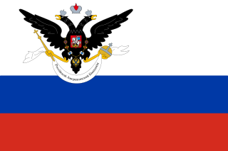
The Russian-American Company Under the High Patronage of His Imperial Majesty was a state-sponsored chartered company formed largely on the basis of the United American Company. Emperor Paul I of Russia chartered the company in the Ukase of 1799. It had the mission of establishing new settlements in Russian America, conducting trade with natives, and carrying out an expanded colonization program.
The Treaty of Kyakhta, along with the Treaty of Nerchinsk (1689), regulated the relations between Imperial Russia and the Qing Empire of China until the mid-19th century. It was signed by Tulišen and Count Sava Lukich Raguzinskii-Vladislavich at the border city of Kyakhta on 23 August 1727.
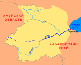
The Uda is a river in Khabarovsk Krai, in the Russian Far East. It is 457 kilometres (284 mi) long, and has a drainage basin of 61,300 square kilometres (23,700 sq mi).

Nerchinsk is a town and the administrative center of Nerchinsky District in Zabaykalsky Krai, Russia, located on the left bank of the Nercha River, 7 kilometers (4.3 mi) above its confluence with the Shilka River, 644 kilometers (400 mi) east of Lake Baikal, about 225 kilometers (140 mi) west of the Chinese border, and 305 kilometers (190 mi) east of Chita, the administrative center of the krai. Population: 14,959 (2010 Census); 15,748 (2002 Census); 16,961 (1989 Census); 6,713 (1897).

Kyakhta is a town and the administrative center of Kyakhtinsky District in the Republic of Buryatia, Russia, located on the Kyakhta River near the Mongolia–Russia border. The town stands directly opposite the Mongolian border town of Altanbulag. Population: 20,041 (2010 Census); 18,391 (2002 Census); 18,307 (1989 Census). From 1727 it was the border crossing for the Kyakhta trade between Russia and China.

Altanbulag is a sum (district) of Selenge Province in northern Mongolia. It is located about 25 km from the provincial capital of Sükhbaatar, on the border with Russia opposite the town of Kyakhta. Altanbulag is the location of the Altanbulag Free Trade Zone.
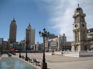
Manzhouli is a sub-prefectural city located in Hulunbuir prefecture-level city, Inner Mongolia Autonomous Region, China. Located on the border with Russia, it is a major land port of entry. It has an area of 696.3 square kilometres (268.8 sq mi) and a population of almost 250,000.
Lorenz or Lorents Lange was an official in 18th-century Siberia who dealt with Russo-Chinese trade and diplomacy. His reports were a major influence on Russian policy and an important early source of European knowledge of Siberia, Mongolia and China. He is usually said to have been a cornet in the Swedish cavalry who was taken prisoner at the Battle of Poltava in 1709.
Prior to the 17th century, China and Russia were on opposite ends of Siberia, which was populated by independent nomads. By about 1640 Russian settlers had traversed most of Siberia and founded settlements in the Amur River basin. From 1652 to 1689, China's armies drove the Russian settlers out, but after 1689, China and Russia made peace and established trade agreements.
Shanxi merchants, also known as Jin merchants, were the group of merchants from Shanxi province, China. Jin is an abbreviated name of Shanxi. Even though the history of noticeable Shanxi merchants can be dated back to as early as the Spring and Autumn Period, more than 2000 years ago, Shanxi merchants became prominent during the Ming and Qing dynasties, and their dominant influence in Chinese commerce, within the nation and with neighboring Mongolia, Russia, and Japan, lasted for more than 500 years.

The Siberian Route, also known as the Moscow Highway and Great Highway, was a historic route that connected European Russia to Siberia and China.
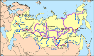
Siberian River Routes were the main ways of communication in Russian Siberia before the 1730s, when roads began to be built. The rivers were also of primary importance in the process of Russian conquest and exploration of vast Siberian territories eastwards. Since the three great Siberian rivers, the Ob, the Yenisey, and the Lena all flow into the Arctic Ocean, the aim was to find parts or branches of these rivers that flow approximately east-west and find short portages between them. Since Siberia is relatively flat, portages were usually short. Despite resistance from the Siberian tribes, Russian Cossacks were able to expand from the Urals to the Pacific in only 57 years (1582-1639). These river routes were crucial in the first years of the Siberian fur trade as the furs were easier to transport over water than land. The rivers connected the major fur gathering centers and provided for relatively quick transport between them.

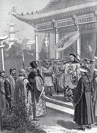
Count Yurii Alexandrovich Golovkin (1762–1846) was a Russian diplomat who served as Russian Minister (ambassador) in Stuttgart (1813–18) and in Vienna (1818–1822), but is best remembered for his leadership of the ambitious mission to China despatched in 1805.
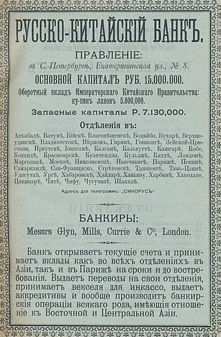
The Russo-Chinese Bank was a foreign bank, founded in 1895, that represented joint French and Russian interests in China during the late Qing dynasty. It merged in 1910 with the French-sponsored Banque du Nord, a large domestic bank in Russia, to form the Russo-Asiatic Bank.

Between 1858 and 1860, the Russian Empire annexed territories adjoining the Amur River belonging to the Chinese Qing dynasty through the imposition of unequal treaties. The 1858 Treaty of Aigun, signed by the general Nikolay Muravyov representing the Russian Empire and the official Yishan representing Qing China, ceded Priamurye—a territory stretching from the Amur River north to the Stanovoy Mountains, but the Qing government initially refused to recognize the treaty's validity. Two years later, the Second Opium War concluded with the Convention of Peking, which affirmed the previous treaty as well as an additional cession including the entire Pacific coast to the Korean border, as well as the island of Sakhalin to Russia. These two territories roughly correspond to modern-day Amur Oblast and Primorsky Krai, respectively. Collectively, they are often referred to as Outer Manchuria, part of the greater region of Manchuria.

The Okhotsk Coast is an informal name for the northwest coast of the Sea of Okhotsk. Although it was never an administrative unit there is some reason to treat it as a distinct region. Here in 1639 the Russians first reached the Pacific Ocean. From here, beginning in 1716, Russian ships sailed east to the Kamchatka Peninsula, the Aleutian Islands and Alaska.
The Chinese–Russian border or the Sino-Russian border is the international border between China and Russia. After the final demarcation carried out in the early 2000s, it measures 4,209.3 kilometres (2,615.5 mi), and is the world's sixth-longest international border. According to the Russian border agency, as of October 1, 2013, there are more than 160 land border crossings between Russia and China, all of these border crossings are open 24 hours. There are crossing points established by the treaty including railway crossings, highway crossings, river crossing, and mostly ferry crossings.

The Kyakhta Trade refers to the trade between Russia and China through the town of Kyakhta on the Mongolian border south of Lake Baikal from 1727. The trade was mostly Siberian furs for Chinese cotton, silk, tobacco and tea.

The siege of Albazin was a military conflict between the Tsardom of Russia and Qing China from 1685 to 1686. It ultimately ended in the surrender of Albazin to Qing China and Russian abandonment of the Amur River area in return for trading privileges in Beijing.
Clifford M Foust," Muscovite and Mandarin: Russia's Trade with China and its Setting, 1727-1805",1969
