Tullibody Old Bridge

Last updated

Tullibody Old Bridge
TullibodyOldBridgeOctober2011.jpg
View from SSE
LocationAlloa Road, Tullibody, Clackmannanshire
Coordinates 56°08′06″N3°51′27″W / 56.13498°N 3.85756°W / 56.13498; -3.85756 Coordinates: 56°08′06″N3°51′27″W / 56.13498°N 3.85756°W / 56.13498; -3.85756
BuiltEarly 16th century
Built forRobert Spittal, philanthropist
Architectural style(s)Stone arch, rubble, ashlar
Listed Building – Category A
Official nameTullibody Old Bridge over the River Devon, Bridgend
Designated9 June 1960
Reference no. LB1977
Clackmannanshire UK location map.svg
Red pog.svg
Location of Tullibody Old Bridge in Clackmannanshire

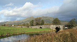
Tullibody Old Bridge, over the River Devon near Tullibody, Clackmannanshire, Scotland, dates from the early 16th century. Disused after 1915, it was restored for use by walkers and cyclists in 2003.

Contents

Sixteenth century

Clackmannanshire Council's public information board names Robert Spittal, the court tailor to James IV and Margaret Tudor and a local philanthropist, as the person probably responsible for the bridge's construction. [1] Spittal was also responsible for the Brig o'Teith over the River Teith at Doune. [2]

Tullibody Old Bridge was built early in the 16th century, constructed of rubble with some ashlar [3] and was designed to impede the rapid transit of horse traffic. [4] The plan shows two opposed bends.[ citation needed ] With two main arches and three flood arches to the west, its great length (442 ft or 134.7m [1] ) probably reflects the difficulty in crossing the flood plain at this point. [4]

The eastern arch was demolished, by William Kirkcaldy of Grange in January 1560, to hamper French troops during the regency of Mary of Guise the mother of Mary, Queen of Scots. The French commander Henri Cleutin improvised a bridge using timbers from the roof of the nearby Tullibody Old Kirk, and carried on from Fife to Stirling. [1] [5] A more permanent repair was made in 1560. [4]

Seventeenth century

In the 17th century the bridge was often in a ruined state but was repaired several times with funds raised by tolls levied on users. In 1697 Thomas Bauchop, a mason, received a contract for repairs from the Earl of Mar. In that year he or his son, Alloa Master Mason Tobias Bauchop, built a new eastern arch and inserted iron ties. [3] [1]

Recent history

The Old Bridge went out of use in 1915 in favour of a lattice steel girder bridge, Downie's Bridge, built a short distance to the north to carry the A907 road. In 1999 the A907 was re-routed over the present concrete structure [4] and the steel bridge, long neglected, was demolished in 2003. [1]

In January 2003, Clackmannanshire Council began restoring the Old Bridge and performed vegetation clearance, resurfacing and structural repairs to the masonry in accordance with conditions laid down by Historic Scotland. The project was completed in January 2005 and Tullibody Old Bridge now forms part of the National Cycle Network in Clackmannanshire. [1]

It is protected as a Category A listed building, [6] and was a Scheduled Ancient Monument until 2016 when this status was removed due to dual designation. [7]

Related Research Articles

<span class="mw-page-title-main">Clackmannanshire</span> Historic county and council area of Scotland

Clackmannanshire, or the County of Clackmannan, is a historic county, council area, registration county and lieutenancy area in Scotland, bordering the council areas of Stirling, Fife, and Perth and Kinross. In terms of historic counties it borders Perthshire, Stirlingshire and Fife.

<span class="mw-page-title-main">River Forth</span> River in central Scotland

The River Forth is a major river in central Scotland, 47 km (29 mi) long, which drains into the North Sea on the east coast of the country. Its drainage basin covers much of Stirlingshire in Scotland's Central Belt. The Gaelic name for the upper reach of the river, above Stirling, is Abhainn Dubh, meaning "black river". The name for the river below the tidal reach is Uisge For.

<span class="mw-page-title-main">Alloa</span> Town in Clackmannanshire, Scotland

Alloa is a town in Clackmannanshire in the Central Lowlands of Scotland. It is on the north bank of the Forth at the spot where some say it ceases to be the River Forth and becomes the Firth of Forth. Alloa is south of the Ochil Hills, 5.5 miles (8.9 km) east of Stirling and 7.9 miles (12.7 km) north of Falkirk; by water Alloa is 25 miles (40 km) from Granton.

<span class="mw-page-title-main">Tillicoultry</span> Town in Clackmannanshire, Scotland

Tillicoultry is a town in Clackmannanshire, Scotland. Tillicoultry is usually referred to as Tilly by the locals.

<span class="mw-page-title-main">Kincardine Bridge</span> Bridge in Scotland

The Kincardine Bridge is a road bridge crossing the Firth of Forth from Falkirk council area to Kincardine, Fife, Scotland.

<span class="mw-page-title-main">Menstrie</span> Human settlement in Scotland

Menstrie is a village in the county of Clackmannanshire in Scotland. It is about five miles east-northeast of Stirling and is one of a string of towns that, because of their location at the foothill base of the Ochil Hills, are collectively referred to as the Hillfoots Villages or simply The Hillfoots.

<span class="mw-page-title-main">Clackmannan</span> Human settlement in Scotland

Clackmannan, is a small town and civil parish set in the Central Lowlands of Scotland. Situated within the Forth Valley, Clackmannan is 1.8 miles (2.9 km) south-east of Alloa and 3.2 miles (5.1 km) south of Tillicoultry. The town is within the county of Clackmannanshire, of which it was formerly the county town, until Alloa overtook it in size and importance.

<span class="mw-page-title-main">River Devon, Clackmannanshire</span> Tributary of the River Forth, Scotland, UK

The River Devon is a tributary of the River Forth in Clackmannanshire, Scotland.

<span class="mw-page-title-main">Tullibody</span> Town in Clackmannanshire, Central Lowlands, Scotland

Tullibody, is a town set in the Central Lowlands of Scotland. It lies north of the River Forth near to the foot of the Ochil Hills within the Forth Valley. The town is 1.8 miles (2.9 km) south-west of Alva, 1.8 miles (2.9 km) north-west of Alloa and 4.0 miles (6.4 km) east-northeast of Stirling. The town is part of the Clackmannanshire council area.

<span class="mw-page-title-main">River Teith</span> River in Scotland

The River Teith is a river in Scotland, which is formed from the confluence of two smaller rivers, the Garbh Uisge and Eas Gobhain at Callander, Stirlingshire. It flows into the River Forth near Drip north-west of Stirling.

<span class="mw-page-title-main">Deanston</span> Human settlement in Scotland

Deanston is a village in the Stirling council area, Scotland, on the south bank of the River Teith east of Doune, in south-west Perthshire. It is a part of the parish of Kilmadock.

<span class="mw-page-title-main">Sauchie</span> Town in Clackmannanshire, Central Lowlands, Scotland

Sauchie is a town in the Central Lowlands of Scotland. It lies north of the River Forth and south of the Ochil Hills, within the council area of Clackmannanshire. Sauchie has a population of around 6000 and is located one mile northeast of Alloa and two miles east-southeast of Tullibody.

<span class="mw-page-title-main">Menstrie Castle</span>

Menstrie Castle is a three-storey manor house in the town of Menstrie, Clackmannanshire, near Stirling, central Scotland. From the early 17th century, it was home to Sir William Alexander, 1st Earl of Stirling, who was instrumental in founding the colony of Nova Scotia. It was later owned by the Holburn or Holborne family, who were created Baronets of Menstrie in 1706. The castle was restored in the 20th century, won a Civic Trust award, and now incorporates holiday accommodation, private flats, and a museum and cafe run by the National Trust for Scotland.

<span class="mw-page-title-main">Sauchie Tower</span> Building in Fishcross, Scotland

Sauchie Tower, also known as Devon Tower, is a 15th-century tower house in Clackmannanshire, Scotland. The tower is located by the village of Fishcross, 1 kilometre (0.62 mi) north of Sauchie and 2.5 kilometres (1.6 mi) north of Alloa, close to the River Devon. It is protected as a Scheduled Ancient Monument.

<span class="mw-page-title-main">Tullibody Old Kirk</span> Ruined 12th century church building in Clackmannanshire, Scotland, UK

Tullibody Old Kirk is a ruined 12th-century church in Tullibody, Clackmannanshire, Scotland. It was rebuilt in the 16th century, and restored again in 1760. The roofless building is protected as a Scheduled Ancient Monument. In 1904, St Serf's Parish Church was built to the north of the Old Kirk, which was afterwards disused.

<span class="mw-page-title-main">Black Devon</span>

The Black Devon is a river in Scotland. It rises in the Cleish Hills, specifically the area known as Outh Muir, 1.5 kilometres (0.93 mi) north of Knockhill Racing Circuit, around 9 kilometres (5.6 mi) north-west of Dunfermline, Fife, with the gathering of three small streams in branch formation. The river flows westwards through Balgonar, north of Saline, and then merges with the Saline Burn. The Black Devon flows into Clackmannanshire, through the hamlet of Forestmill and past the town of Clackmannan. The Black Devon enters the River Forth south of Alloa, 1 kilometre (0.62 mi) north of Dunmore Pier.

<span class="mw-page-title-main">Cambus, Clackmannanshire</span> Village in Clackmannanshire, Scotland

Cambus is a village near Alloa, Clackmannanshire. It is located to the south of Tullibody, to the northwest of Alloa, and about 4 miles east of Stirling, across the river. It lies on the River Devon, near its confluence with the River Forth.

<span class="mw-page-title-main">Robert Spittell</span>

Robert Spittell or Spittall or Spittale was a Scottish tailor who served Margaret Tudor, queen consort of James IV of Scotland.

References

  1. 1 2 3 4 5 6 "Tullibody Old Bridge". Clackmannanshire Council, public information board. Archived from the original on 11 November 2012.
  2. Louis Stott, 'Bridges of the Forth', Forth Naturalist and Historian, vol. 22 (1999), p. 143.
  3. 1 2 "Conservation audit". Robin Kent Architecture & Conservation.
  4. 1 2 3 4 "The Forth Naturalist and Historian vol. 22 p. 138" (PDF).
  5. Laing, David, ed., 'John Knox's 'History of the Reformation', Book 3,' The Works of John Knox, vol. 2 (Bannatyne Club: Edinburgh, 1848), p. 14
  6. Historic Environment Scotland. "Tullibody Old Bridge over River Devon, Bridgend (Category A Listed Building) (LB1977)" . Retrieved 27 March 2019.
  7. Historic Environment Scotland. "Tullibody,old bridge 1600m W of (Status: Removed) (SM630)" . Retrieved 27 March 2019.