Related Research Articles
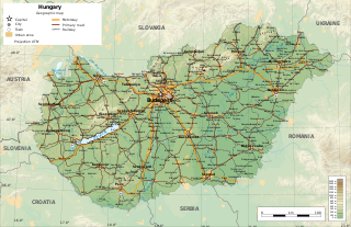
Hungary is a landlocked country in East-Central Europe with a land area of 93,030 square km. It measures about 250 km from north to south and 524 km from east to west. It has 2,106 km of boundaries, shared with Austria to the west, Serbia, Croatia and Slovenia to the south and southwest, Romania to the southeast, Ukraine to the northeast, and Slovakia to the north.

With an area of 238,397 km2 (92,046 sq mi), Romania is the twelfth-largest country in Europe. Located in Central and Southeastern Europe, bordering on the Black Sea, the country is halfway between the equator and the North Pole and equidistant from the westernmost part of Europe—the Atlantic Coast—and the most easterly—the Ural Mountains. Romania has 3,195 kilometres (1,985 mi) of border. Republic of Moldova and Ukraine lie to the east, Bulgaria lies to the south, and Serbia and Hungary to the west. In the southeast, 245 kilometres (152 mi) of sea coastline provide an important outlet to the Black Sea and the Atlantic Ocean.

The geography of Ukraine varies greatly from one region of the country to another, with the majority of the country lying within the East European Plain. Ukraine is one of the largest European countries. Its various regions have diverse geographic features ranging from highlands to lowlands, as well as climatic range and a wide variety in hydrography.

The Vardar or Axios is the longest river in North Macedonia and the second longest river in Greece, in which it reaches the Aegean Sea at Thessaloniki. It is 388 km (241 mi) long, out of which 76 km (47 mi) are in Greece, and drains an area of around 25,000 km2 (9,653 sq mi). The maximum depth of the river is 4 m (13 ft).

The Tisza, Tysa or Tisa, is one of the major rivers of Central and Eastern Europe. Once, it was called "the most Hungarian river" because it flowed entirely within the Kingdom of Hungary. Today, it crosses several national borders.

Serbia is a country situated at the crossroads of Central and Southeast Europe, covering the far southern edges of the Pannonian Plain and the central Balkans. It shares borders with Bosnia-Herzegovina, Bulgaria, Croatia, Hungary, North Macedonia, Montenegro, Romania and Albania. Serbia is landlocked, though it is able to access the Adriatic Sea through Montenegro and inland Europe and the Black Sea via the Danube.

The Morava is a river in Central Europe, a left tributary of the Danube. It is the main river of Moravia, which derives its name from it. The river originates on the Králický Sněžník mountain in the north-eastern corner of Pardubice Region, near the border between the Czech Republic and Poland and has a vaguely southward trajectory. The lower part of the river's course forms the border between the Czech Republic and Slovakia and then between Austria and Slovakia.

The Timiș or Tamiš is a 359 km (223 mi) long river that flows through the Banat region of Romania and Serbia and joins the Danube near Pančevo, in northern Serbia. Due to its position in the region, it has been labeled as the "spine of the Banat".

The Great Morava is the final section of the Morava, a major river system in Serbia.

The Ialomița is a river of Southern Romania. It rises from the Bucegi Mountains in the Carpathians. It discharges into the Borcea branch of the Danube in Giurgeni. It is 417 km (259 mi) long, and its basin area is 10,350 km2 (4,000 sq mi). Its average discharge at the mouth is 45 m3/s (1,600 cu ft/s). Ialomița County takes its name from this river.

The Rio Grande de Mindanao, also known as the Mindanao River, is the second-largest river system in the Philippines. Located on the southern island of Mindanao, with a total drainage area of 23,169 km2 (8,946 sq mi), draining the majority of the central and eastern portion of the island, and a total length of approximately 373 km (232 mi). It is an important transportation artery, used mainly in transporting agricultural products and, formerly, timber.
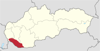
Žitný ostrov, also called Veľký Žitný ostrov to differentiate it from Malý Žitný ostrov, is a river island in southwestern Slovakia, extending from Bratislava to Komárno. It lies between the Danube, its tributary Little Danube and Váh. The island is a major part of the Danubian Flat. It is the biggest river island in Europe, with an area of 1,886 km2 (728 sq mi), measuring 84 km (52 mi) in length and 15 to 30 km in width.

The Timok, sometimes also known as Great Timok, is a river in eastern Serbia, a right tributary of the Danube. For the last 15 km of its run it forms a border between eastern Serbia and western Bulgaria.
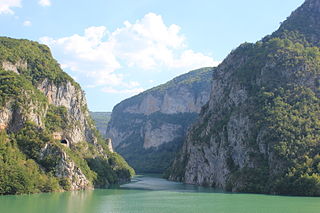
The Lim is a river that flows through Montenegro, Serbia and Bosnia and Herzegovina and is 219 km (136 mi) long. It is also the right and the longest tributary of the Drina.

The Bega or Begej, is a 244 km long river in Romania and Serbia. It rises in the Poiana Ruscă Mountains in Romania, part of the Carpathian Mountains, and it flows into the Tisa river near Titel, Vojvodina, Serbia. Its drainage basin covers an area of 4,458 km2 (1,721 sq mi), of which 2,362 km2 (912 sq mi) in Romania.

The Danube is the second-longest river in Europe, after the Volga in Russia. It flows through much of Central and Southeastern Europe, from the Black Forest into the Black Sea. Its longest headstream Breg rises in Furtwangen im Schwarzwald, while the river carries its name from its source confluence in Donaueschingen onwards.

The hydrology of Hungary, is mostly determined by Hungary's lying in the middle of the Carpathian Basin, half surrounded by the Carpathian Mountains. All parts of the country have some outflow. All surface water gravitates towards its southern center, and from there, is united in the Danube, which flows into the Black Sea. The whole of Hungary lies within the Danube drainage basin.