Related Research Articles

Belfast is the capital and largest city of Northern Ireland, standing on the banks of the River Lagan on the east coast. It is the 12th-largest city in the United Kingdom and the second-largest on the island of Ireland. It had a population of 343,542 in 2019. Belfast suffered greatly during the violence that accompanied the partition of Ireland, and especially during the more recent conflict known as the Troubles.

Castlereagh was a local government district with the status of borough in Northern Ireland. It merged with Lisburn City Council in May 2015 under local government reorganisation in Northern Ireland to become Lisburn and Castlereagh City Council, with a small amount being transferred to Belfast City Council.

Lurgan is a town in County Armagh, Northern Ireland, near the southern shore of Lough Neagh. Lurgan is about 18 miles (29 km) south-west of Belfast and is linked to the city by both the M1 motorway and the Belfast–Dublin railway line. It had a population of about 25,000 at the 2011 Census and is within the Armagh, Banbridge and Craigavon district. For some purposes, Lurgan is treated as part of the "Craigavon Urban Area" along with neighbouring Craigavon and Portadown.

Craigavon is a planned settlement in northern County Armagh, Northern Ireland. Its construction began in 1965 and it was named after the first Prime Minister of Northern Ireland: James Craig, 1st Viscount Craigavon. It was intended to be the heart of a new linear city incorporating Lurgan and Portadown, but this plan was mostly abandoned and later described as having been flawed. Among local people today, "Craigavon" refers to the area between the two towns. It is built beside a pair of artificial lakes and is made up of a large residential area (Brownlow), a second smaller one (Mandeville), plus a central area (Highfield) that includes a substantial shopping centre, a courthouse and the district council headquarters. The area around the lakes is a public park and wildlife haven made up of woodland with walking trails. There is also a watersports centre, golf course and ski slope in the area. In most of Craigavon, motor vehicles are completely separated from pedestrians, and roundabouts are used extensively. It hosted the headquarters of the former Craigavon Borough Council.
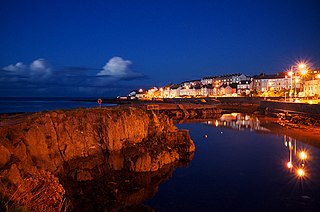
Bangor is a town in County Down, Northern Ireland. It is a seaside resort on the southern side of Belfast Lough and within the Belfast Metropolitan Area. It functions as a commuter town for the Greater Belfast area, which it is linked to by the A2 road and the Belfast–Bangor railway line. Bangor is situated 13.6 miles (22 km) east from the heart of Belfast. The population was 61,011 at the 2011 Census.
Carnmoney is the name of a townland, electoral ward and a civil parish in County Antrim, Northern Ireland. Carnmoney is within the urban area of Newtownabbey, in the Antrim and Newtownabbey Borough Council area. It lies 7 miles (11 km) from Belfast city centre in the historic barony of Belfast Lower.

Kanata is a major suburb of the Canadian capital of Ottawa, Ontario. It is about 22 km (14 mi) west of the city's downtown core. As of 2016, Kanata had a population of 98,938 and is growing. Before it was amalgamated into Ottawa in 2001, it was one of the fastest-growing cities in Canada and the fastest-growing community in Eastern Ontario. Located just to the west of the National Capital Commission Greenbelt, it is one of the largest of several communities that surround central Ottawa.

Beaghmore is a complex of early Bronze Age megalithic features, stone circles and cairns, 8.5 miles north west of Cookstown, County Tyrone in Northern Ireland, on the south-east edge of the Sperrin Mountains.

Belfast City Council is the local authority with responsibility for part of the city of Belfast, the capital and largest city of Northern Ireland. The Council serves an estimated population of 333,871 (2011), the largest of any district council in Northern Ireland, while being the smallest by area. Belfast City Council is the primary council of the Belfast Metropolitan Area, a grouping of six former district councils with commuter towns and overspill from Belfast, containing a total population of 579,276.

The Falls Road is the main road through West Belfast, Northern Ireland, running from Divis Street in Belfast City Centre to Andersonstown in the suburbs. The name has been synonymous for at least a century and a half with the Catholic community in the city. The road is usually referred to as the Falls Road, rather than as Falls Road. It is known in Irish as the Bóthar na bhFál and as the Faas Raa in Ulster-Scots.

Rathcoole is a housing estate in Newtownabbey, County Antrim, Northern Ireland. It was built in the 1950s to house many of those displaced by the demolition of inner city housing in Belfast city. Rathcoole is within the wider Antrim and Newtownabbey Borough. Its approximate borders are provided by O'Neill Road on the north, Doagh Road on the east, Shore Road on the south and Church Road and Merville Garden Village on the west.
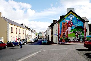
Cushendall, formerly known as Newtownglens, is a coastal village and townland in County Antrim, Northern Ireland. It is in the historic barony of Glenarm Lower and the civil parish of Layd, and is part of Causeway Coast and Glens district.

Cregagh is an area southeast of Belfast in County Down, Northern Ireland. It is the name of a townland and has been adopted as the name of an electoral ward of Belfast City council. The townland dates back to medieval times, when it was part of the territory held by the O'Neills of Clannaboy. The area is centred on the Cregagh Road. The Woodstock/Cregagh Road is a continuous arterial route in the city, with the Woodstock making up the lower half of the route and the Cregagh the upper half. It runs from the Albertbridge Road, close to the Short Strand, to the A55 Outer Ring road.

The Donegall Road is a residential area and road traffic thoroughfare that runs from Shaftesbury Square on what was once called the "Golden Mile" to the Falls Road in west Belfast. The road is bisected by the Westlink – M1 motorway. The largest section of the road, east of the Broadway junction with the Westlink, has a community which self-identifies as predominantly Protestant while the community on the other side of the Westlink – M1 motorway self-identifies as predominantly Catholic.

Tievebulliagh is a 402-metre-high (1,319 ft) mountain in the Glens of Antrim, Northern Ireland. It forms part of the watershed between Glenaan to the north and Glenballyemon to the south. It is situated about 4.4 km from Cushendall.
The Comber Greenway is a 7-mile (11 km) traffic-free section of the National Cycle Network that runs along the old Belfast-Comber railway line. The cycle path starts on Dee Street in east Belfast and finishes at Comber in County Down. As well as a cycling path, it is also popular with people on foot. The most recent addition to the route was in November 2008 when the final link between Old Dundonald Road/Comber Rd junction and Comber was opened. This added 1.6 miles (2.6 km) to the route. One section runs through a SLNCI-designated Wetland ecosystem.

Lisburn and Castlereagh is a local government district in Northern Ireland. The district was created on 1 April 2015. It consists of the combined area of the City of Lisburn with the Borough of Castlereagh, but not including "the localities of Gilnahirk, Tullycarnet, Braniel, Castlereagh, Merok, Cregagh, Wynchurch, Glencregagh and Belvoir, Collin Glen, Poleglass, Lagmore, Twinbrook, Kilwee and Dunmurry" which transferred to Belfast. The local authority is Lisburn and Castlereagh City Council.
Braniel or The Braniel is a large housing estate and townland in southeast Belfast, Northern Ireland. It is in the barony of Castlereagh Upper and parish of Knockbreda in County Down. Two small developments, Roddens and Glenview, are located in the area, and are often referred to the Braniel. It is a predominantly unionist area.

The Shore Road is a major arterial route and area of housing and commerce that runs through north Belfast and Newtownabbey in Northern Ireland. It forms part of the A2 road, a traffic route which links Belfast to the County Antrim coast.

Clarawood is a housing estate in Belfast, Northern Ireland. It is located in the east of the city and incorporates the neighbouring Richhill development. Its name is probably derived from An Chlárach. It is located off Knock Road (A55).
References
- ↑ "Place Names NI - Home".
- ↑ "Parks and open spaces in Belfast".
- ↑ "Community centres".
- ↑ "Tullycarnet Library". Archived from the original on 25 January 2014.