
Lambeth is a London borough in South London, England, which forms part of Inner London. Its name was recorded in 1062 as Lambehitha and in 1255 as Lambeth. The geographical centre of London is at Frazier Street near Lambeth North tube station, though nearby Charing Cross on the other side of the Thames in the City of Westminster is traditionally considered the centre of London.

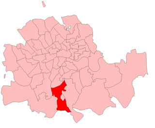
Lambeth was a civil parish and metropolitan borough in south London, England. It was an ancient parish in the county of Surrey. The parish was included in the area of responsibility of the Metropolitan Board of Works in 1855 and became part of the County of London in 1889. The parish of Lambeth became a metropolitan borough in 1900, following the London Government Act 1899, with the parish vestry replaced by a borough council.
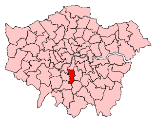
Dulwich and West Norwood is a constituency in South London created in 1997. It has been represented by Helen Hayes of Labour since her election in 2015.
Streatham is a constituency represented in the House of Commons of the UK Parliament since 2019 by Bell Ribeiro-Addy of the Labour Party.
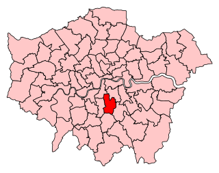
Norwood was a parliamentary constituency in south London which returned one Member of Parliament (MP) to the House of Commons of the Parliament of the United Kingdom by the first past the post system.

Holborn and Covent Garden is a ward of the London borough of Camden, in the United Kingdom. As the name suggests, it covers the parts of Holborn and Covent Garden that lie in Camden; the eastern part of Holborn lies in the City of London and the southern part of Covent Garden lies in the City of Westminster. For elections to Parliament, Holborn and Covent Garden is part of Holborn and St Pancras.

Vassall ward was an administrative division of the London Borough of Lambeth, United Kingdom, from 1965 to 2022. It was located in the north of borough bordering Southwark, in the SW9 and SE5 postcode area. The ward was named after Henry Vassall-Fox, 3rd Baron Holland who was responsible for the first building development in the area in the 1820s.
Coldharbour ward was an administrative division of the London Borough of Lambeth from 2002 to 2022. It is located in Brixton. The ward was replaced in 2022 by Brixton Acre Lane, Brixton Rush Common, Brixton Windrush, Herne Hill and Loughborough Junction, and Brixton North.
Herne Hill was an administrative division of the London Borough of Lambeth, England from 1965 to 2022. It was located in Herne Hill and contained Brockwell Park, Ruskin Park and Herne Hill railway station. Loughborough Junction railway station and King's College Hospital were also partially located within the ward. At the 2011 Census the population of the ward was 15,107.
Clapham Town is an administrative division of the London Borough of Lambeth, England.
Stockwell was an administrative ward of the London Borough of Lambeth, England from 1965 to 2022. It contained much of the area known as Stockwell.
Brixton Hill ward was an administrative division of the London Borough of Lambeth, England from 2002 to 2022.
Thurlow Park ward was an administrative division of the London Borough of Lambeth, England from 1965 to 2022.
Clapham Common was an administrative division of the London Borough of Lambeth, United Kingdom from 2002 to 2022.
Streatham St Leonard's is an electoral ward in the London Borough of Lambeth, United Kingdom. The ward has existed since the creation of the borough on 1 April 1965 and was first used in the 1964 elections. It returns three councillors to Lambeth London Borough Council.
Streatham South ward was an administrative division of the London Borough of Lambeth, United Kingdom from 1965 to 2022.
Streatham Wells ward is an administrative division of the London Borough of Lambeth, United Kingdom. It contains part of Streatham town centre to the east of the A23 Streatham High Road. The population of the ward at the 2011 Census was 14,906.
Knight's Hill ward is an administrative division of the London Borough of Lambeth, United Kingdom, roughly covering the West Norwood area.
Gipsy Hill ward is an administrative division of the London Borough of Lambeth, England.

Knight's Hill is a hill in the Tulse Hill and West Dulwich area of the London Borough of Lambeth.
