Tuqtu (Canas-Chumbivilcas)

Last updated
Tuqtu
Peru physical map.svg
Red triangle with thick white border.svg
Tuqtu
Peru
Highest point
Elevation 4,400 m (14,400 ft) [1]
Coordinates 14°23′30″S71°33′15″W / 14.39167°S 71.55417°W / -14.39167; -71.55417 Coordinates: 14°23′30″S71°33′15″W / 14.39167°S 71.55417°W / -14.39167; -71.55417
Geography
Location Peru, Cusco Region, Canas Province, Chumbivilcas Province
Parent range Andes

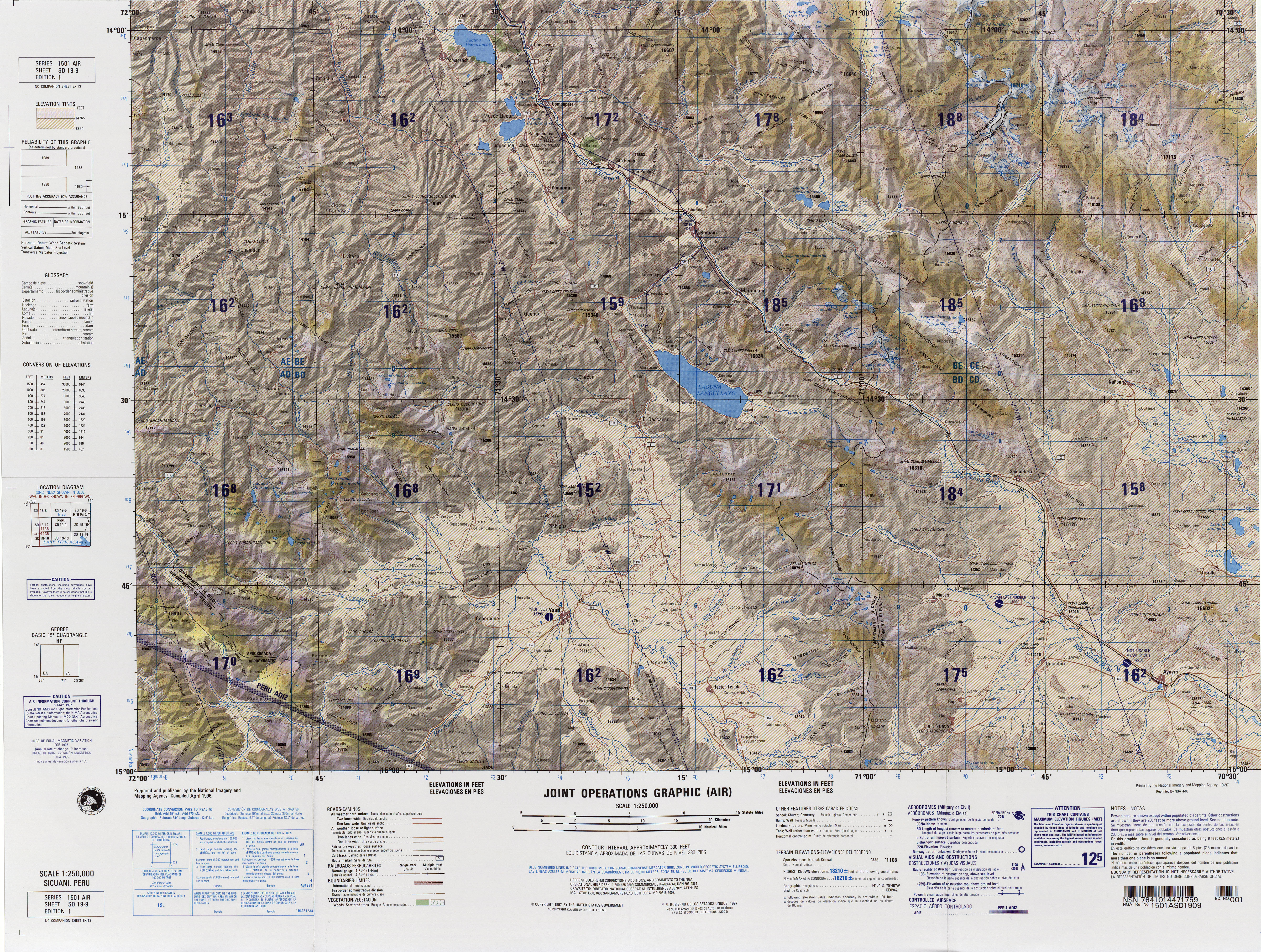
Tuqtu (Quechua for "broody hen", [2] also spelled Tucto) is a mountain in the Andes of Peru. Its summit reaches about 4,400 m (14,436 ft) above sea level. The mountain is located in the Cusco Region, Canas Province, Quehue District, and in the Chumbivilcas Province, Livitaca District. [1] Annually the Tupay Tuqtu festival which has been declared a National Cultura Heritage takes places at the mountain. [3]

Andes oo la laa

The Andes or Andean Mountains are the longest continental mountain range in the world, forming a continuous highland along the western edge of South America. This range is about 7,000 km (4,300 mi) long, about 200 to 700 km wide, and of an average height of about 4,000 m (13,000 ft). The Andes extend from north to south through seven South American countries: Venezuela, Colombia, Ecuador, Peru, Bolivia, Chile and Argentina.

Peru republic in South America

Peru, officially the Republic of Peru, is a country in western South America. It is bordered in the north by Ecuador and Colombia, in the east by Brazil, in the southeast by Bolivia, in the south by Chile, and in the west by the Pacific Ocean. Peru is a megadiverse country with habitats ranging from the arid plains of the Pacific coastal region in the west to the peaks of the Andes mountains vertically extending from the north to the southeast of the country to the tropical Amazon Basin rainforest in the east with the Amazon river.

Southwest of Tuqtu, also on the border of the provinces of Canas and Chumbivilcas, there is a 4,750.9-metre-high (15,587 ft) peak named Tuqtu (Tocto). [4] It lies at 14°24′50″S71°31′00″W / 14.41389°S 71.51667°W / -14.41389; -71.51667 .

Related Research Articles

Chumbivilcas Province Province in Cusco, Peru

Chumbivilcas(3D-map) is a province in the Andes in South Peru. The Inca called it "Chumpiwillka". The seat of the province is Santo Tomás. Officially Chumbivilcas was founded on June 21, 1825.

Canas Province Province in Cusco, Peru

Canas Province is one of thirteen provinces in the Cusco Region in the southern highlands of Peru.

Checca District District in Cusco, Peru

Checca District is the largest of eight districts in the Canas Province in Peru. Its seat is Checca.

Quehue District District in Cusco, Peru

Quehue is one of eight districts in the Canas Province in Peru. Its seat is the village of Quehue.

Túpac Amaru District District in Cusco, Peru

Tupac Amaru District is one of eight districts in the Canas Province in Peru. Its seat is the village of Tungasuca.

Paruro Province Province in Cusco, Peru

Paruro Province is one of thirteen provinces in the Cusco Region in the southern highlands of Peru.

Chamaca is one of eight districts of the Chumbivilcas Province in Peru.

Livitaca District is one of eight districts of the Chumbivilcas Province in Peru.

Quiñota District is one of eight districts of the Chumbivilcas Province in Peru.

Velille District is one of eight districts of the province Chumbivilcas in Peru.

San Jerónimo District is one of eight districts of the Cusco Province in Peru. It is home to the Universidad Andina del Cusco. According to the 2007 census, there are 31,687 residents in the district. A large part of the population communicates in Quechua.

Chiyar Jaqhi (Cusco) mountain in Peru

Ch'iyar Jaqhi is a mountain the Andes of Peru, about 4,654 m (15,269 ft) high. It lies in the Cusco Region, Canas Province, on the border of the districts Langui, Quehue and Yanaoca.

Tupay Tuqtu is a festival held annually on February 2 at the mountain Tuqtu in the Cusco Region in Peru. On April 1, 2008, it was declared a National Cultural Heritage by Resolución Directoral Nacional No.466-INC. The event takes place in a plain named Winch'iri on the border of the districts Quehue of the Canas Province and Livitaca of the Chumbivilcas Province.

Tikapallana mountain in Peru

T'ikapallana is a mountain in the Andes of Peru. Its summit reaches about 4,304.1 m (14,121 ft) above sea level. T'ikapallana is situated in the Cusco Region, Chumbivilcas Province, Chamaca District.

Anka Wachana (Chumbivilcas) mountain in Peru

Anka Wachana is a mountain in the Andes of Peru. Its summit reaches about 4,640.9 m (15,226 ft) above sea level. Anka Wachana is situated in the Cusco Region, Chumbivilcas Province, Velille District.

Hatun Urqu (Chumbivilcas)

Hatun Urqu is a mountain in the Cusco Region in Peru, about 4,400 metres (14,436 ft) high. It is situated in the Chumbivilcas Province, Velille District, south-east of Velille.

Hatun Chaqu mountain in Peru

Hatun Ch'aqu is a mountain in the Andes of Peru, about 5,000 metres (16,404 ft) high. It is located in the Cusco Region, Canchis Province, Pitumarca District, and in the Quispicanchi Province, Cusipata District. It lies south-west of the mountain Ch'aqu, west of the mountain Yanaqaqa, north-west of the mountain Tiklla Q'asa and north of the mountain Tuqtu. Its ridge stretches to the north-west.

Tuqtu may refer to:

Jatun Huaychahui (mountain) mountain in Peru

Jatun Huaychahui also known as Huaychahui, is a 5,445-metre-high (17,864 ft) mountain in the Andes of Peru. It is the highest mountain in the Huanzo mountain range. Jatun Huaychahui is located in the Arequipa Region, on the border of the Condesuyos Province, Cayarani District, and the La Unión Province, Puyca District, and in the Cusco Region, Chumbivilcas Province, Santo Tomás District. It lies southwest of Huiscatongo.

Siqi Urqu mountain in Peru

Siq'i Urqu is a mountain in the Andes of Peru which reaches a height of approximately 4,850 m (15,910 ft). It is located in the Cusco Region, Chumbivilcas Province, Santo Tomás District, and in the Espinar Province, Coporaque District.

References

  1. 1 2 escale.minedu.gob.pe - UGEL map of the Chumbivilcas Province (Cusco Region)
  2. Teofilo Laime Ajacopa, Diccionario Bilingüe Iskay simipi yuyayk'ancha, La Paz, 2007 (Quechua-Spanish dictionary)
  3. "Costumbre Batalla Ritual del Tupay Toqto". mincetur. Retrieved July 1, 2014.
  4. "South America Maps". Joint Operations Graphic. Retrieved July 1, 2014.