
Baix Llobregat is a comarca (county) on the coast of Catalonia, Spain. Its capital is Sant Feliu de Llobregat.
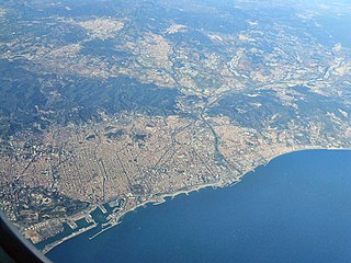
Barcelona is a province of eastern Spain, in the center of the autonomous community of Catalonia. The province is bordered by the provinces of Tarragona, Lleida, and Girona, and by the Mediterranean Sea. Its area is 7,726 km2 (2,983 sq mi). 5,609,350 people live in the province, of whom about 30% (1,620,343) live within the administrative limits of the city of Barcelona, which itself is contained in the Barcelona metropolitan area.
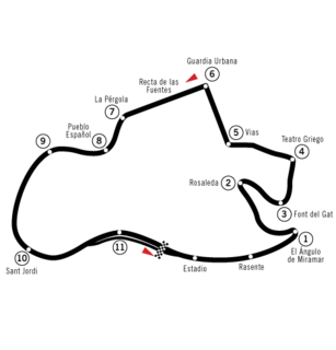
The Montjuïc circuit is a former street circuit located on the Montjuïc mountain in Barcelona, Catalonia, Spain. The circuit was also the venue for the Spanish motorcycle Grand Prix from 1950 to 1968, and then hosted the event on even-numbered years until 1976. The last Formula One Grand Prix held there in 1975, is notable for both a fatal crash that led to Formula One abandoning the venue and the only occasion to date that a female driver has scored World Championship points.

The Statistical Institute of Catalonia is the official body responsible for collecting and publishing statistics in the autonomous community of Catalonia, Spain. The institute comes under the Department of the Economy and Finances of the Generalitat de Catalunya.
Turó de Morou is a mountain of Catalonia, Spain. It has an elevation of 1,303 metres above sea level.

Sant Jeroni is a mountain of Catalonia, Spain. It has an elevation of 1,236 metres above sea level.

Turó de Tagamanent is a mountain of Catalonia, Spain. It has an elevation of 1,055 metres above sea level.
Turó de Bellver is a mountain of Catalonia, Spain. It has an elevation of 1,041 metres above sea level.
Puig Castellar (Balenyà) is a mountain of Catalonia, Spain. It has an elevation of 1,017 metres above sea level.
Punta de la Barrina is a mountain of Catalonia, Spain. It has an elevation of 1,013 metres above sea level.
Turó de Sant Elies is a mountain of Catalonia, Spain. It has an elevation of 1,003 m (3,291 ft) above sea level.
Puig Cornador is a mountain of Catalonia, Spain. It has an elevation of 859 metres above sea level.
Turó del Galutxo is a mountain of Catalonia, Spain. It has an elevation of 851 metres above sea level.

Turó de la Creu de Gurb is a mountain of Catalonia, Spain. It has an elevation of 841 metres above sea level.
Puig-l'agulla is a mountain of Catalonia, Spain. It has an elevation of 810 metres above sea level.
La Cogulla is a mountain of Catalonia, Spain. It has an elevation of 785 metres above sea level.
Turó Gros is a mountain of Catalonia, Spain. It has an elevation of 766 metres above sea level.
Puig Cornador is a mountain of Catalonia, Spain. It has an elevation of 621 metres above sea level.

The 2010 Catalan autonomy protest was a demonstration in central Barcelona on 10 July 2010 against limitations of the autonomy of Catalonia, and particularly against a recent decision of the Spanish Constitutional Court to annul or reinterpret several articles of the 2006 Statute of Autonomy of Catalonia. The number of people taking part in the demonstration was estimated at between 1.1 million and 1.5 million, while Madrid-based newspaper El País estimated the number of demonstrators at 425,000. The mobilisation was described as "unprecedented" by the mayor of Barcelona. The Barcelona daily newspaper El Periódico de Catalunya described it as "without a doubt one of the biggest protest marches that has ever occurred in Catalonia, possibly the biggest". It is thought that the 2012 Catalan independence demonstration involved more people, but this protest brought the dispute to light in the world.

The Catalan Transversal Range is a system of minor mountain ranges at the eastern end of the Pre-Pyrenees, between the Osona and Garrotxa comarques. The existence of the Catalan Transversal Range has made communications in the northern areas of Catalonia difficult in the past, especially between Northeastern Catalonia and Western Catalonia, a problem that has been partly solved with the development of the Eix Transversal.


