Turbid Lake

Last updated
Turbid Lake
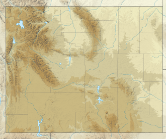
USA Wyoming location map.svg
Red pog.svg
Turbid Lake
Location Park County, Wyoming
Coordinates 44°33′00″N110°15′39″W / 44.549906°N 110.260925°W / 44.549906; -110.260925 Coordinates: 44°33′00″N110°15′39″W / 44.549906°N 110.260925°W / 44.549906; -110.260925
Type lake

Turbid Lake is a lake in Park County, Wyoming, in the United States. [1] Turbid Lake was so named on account of its muddy water. [2]

The lake is believed to have formed in the crater of a hydrothermal explosion some time around 1300 BC, which created a 4,200 by 5,000 by 100 ft (1,280 by 1,524 by 30 m) crater, the floor of which eventually filled up to form the lake.
Related Research Articles

<span class="mw-page-title-main">Mount Erebus</span> Volcano on Ross Island, Antarctica

Mount Erebus is the second-highest volcano in Antarctica, the highest active volcano in Antarctica, and the southernmost active volcano on Earth. It is the sixth-highest ultra mountain on the continent. With a summit elevation of 3,794 metres (12,448 ft), it is located in the Ross Dependency on Ross Island, which is also home to three inactive volcanoes: Mount Terror, Mount Bird, and Mount Terra Nova.

<span class="mw-page-title-main">Mono–Inyo Craters</span> Volcanic chain in eastern California, United States

The Mono–Inyo Craters are a volcanic chain of craters, domes and lava flows in Mono County, Eastern California. The chain stretches 25 miles (40 km) from the northwest shore of Mono Lake to the south of Mammoth Mountain. The Mono Lake Volcanic Field forms the northernmost part of the chain and consists of two volcanic islands in the lake and one cinder cone volcano on its northwest shore. Most of the Mono Craters, which make up the bulk of the northern part of the Mono–Inyo chain, are phreatic volcanoes that have since been either plugged or over-topped by rhyolite domes and lava flows. The Inyo volcanic chain form much of the southern part of the chain and consist of phreatic explosion pits, and rhyolitic lava flows and domes. The southernmost part of the chain consists of fumaroles and explosion pits on Mammoth Mountain and a set of cinder cones south of the mountain; the latter are called the Red Cones.

<span class="mw-page-title-main">Mount Mazama</span> Complex volcano in the Cascade Range

Mount Mazama is a complex volcano in the state of Oregon, United States, in a segment of the Cascade Volcanic Arc and Cascade Range. Most of the mountain collapsed following a major eruption approximately 7,700 years ago. The volcano is in Klamath County, in the southern Cascades, 60 miles (97 km) north of the Oregon–California border. Its collapse formed a caldera that holds Crater Lake. The mountain is in Crater Lake National Park. Mount Mazama originally had an elevation of 12,000 feet (3,700 m), but following its climactic eruption this was reduced to 8,157 feet (2,486 m). Crater Lake is 1,943 feet (592 m) deep, the deepest freshwater body in the US and the second deepest in North America after Great Slave Lake in Canada.

<span class="mw-page-title-main">Owens River</span> River in eastern California

The Owens River is a river in eastern California in the United States, approximately 183 miles (295 km) long. It drains into and through the Owens Valley, an arid basin between the eastern slope of the Sierra Nevada and the western faces of the Inyo and White Mountains. The river terminates at the endorheic Owens Lake south of Lone Pine, at the bottom of a 2,600 sq mi (6,700 km2) watershed.

<span class="mw-page-title-main">Puʻu ʻŌʻō</span> Volcanic cone in the Hawaiian Islands

Puʻu ʻŌʻō is a volcanic cone on the eastern rift zone of Kīlauea volcano in the Hawaiian Islands. The eruption that created Puʻu ʻŌʻō began on January 3, 1983, and continued nearly continuously until April 30, 2018, making it the longest-lived rift-zone eruption of the last two centuries.

<span class="mw-page-title-main">Saunders Island, South Sandwich Islands</span>

Saunders Island is a crescent-shaped island 8.8 km (5.5 mi) long, lying between Candlemas Island and Montagu Island in the South Sandwich Islands, a British Overseas Territory in the southern Atlantic Ocean. It is a volcanic island composed of an active stratovolcano, 990-metre (3,248 ft) Mount Michael.

<span class="mw-page-title-main">Mount Emmons (Alaska)</span> Post-caldera stratovolcano in the state of Alaska

Mount Emmons is a post-caldera stratovolcano within the Emmons Lake caldera on the Alaska Peninsula within the Lake and Peninsula Borough, Alaska, United States.

<span class="mw-page-title-main">Mowich Lake</span> Body of water

Mowich Lake is a lake located in the northwestern corner of Mount Rainier National Park in Washington state at an elevation of 4,929 feet (1,502 m). The name "Mowich" derives from the Chinook jargon word for deer.

<span class="mw-page-title-main">Wichita Mountains Wildlife Refuge</span> Protected mixed grass prairie on Oklahoma

Wichita Mountains Wildlife Refuge, located in southwestern Oklahoma near Lawton, has protected unique wildlife habitats since 1901 and is the oldest managed wildlife facility in the United States Fish and Wildlife Service system. The refuge's location in the geologically unique Wichita Mountains and its areas of undisturbed mixed grass prairie make it an important conservation area. The Wichita Mountains are approximately 500 million years old. Measuring about 59,020 acres (238.8 km2), the refuge hosts a great diversity of species: 806 plant species, 240 species of birds, 36 fish, and 64 reptiles and amphibians are present.

<span class="mw-page-title-main">Battle Ground Lake State Park</span>

Battle Ground Lake State Park is a 275-acre (111 ha) public recreation area located three miles (4.8 km) northeast of the city of Battle Ground, Washington. The state park is covered by an evergreen forest located around a crater lake of volcanic origin. The park is managed by the Washington State Parks and Recreation Commission.

<span class="mw-page-title-main">Wizard Island</span> Volcanic cinder cone

Wizard Island is a volcanic cinder cone which forms an island at the west end of Crater Lake in Crater Lake National Park, Oregon. The top of the island reaches 6,933 feet (2,113 m) above sea level, about 755 feet (230 m) above the average surface of the lake.

Hole-in-the-Ground is a large maar in the Fort Rock–Christmas Lake Valley basin of Lake County, central Oregon, northeast of Crater Lake, near Oregon Route 31.

<span class="mw-page-title-main">Stony Clove Creek</span> River in New York, United States

Stony Clove Creek is a 10.3-mile-long (16.6 km) creek in the Catskill Mountains in New York. It is a tributary of Esopus Creek, which in turn is a tributary of the Hudson River. It joins the Esopus in the village of Phoenicia, and has two smaller tributaries up north of Phoenicia.

<span class="mw-page-title-main">Black Crater</span> Shield volcano in central Oregon, United States

Black Crater is a shield volcano in the Western Cascades in Deschutes County, Oregon. Located near McKenzie Pass, the volcano has a broad conical shape with gentle slopes. The volcano likely formed during the Pleistocene and has not been active within the last 50,000 years. Eruptive activity at the volcano produced mafic lava flows made of basaltic andesite and olivine basalt; it also formed a number of cinder cones. A normal fault occurs on the western side of the volcano, trending north–south. The volcano has been eroded by glaciers, which carved a large cirque into the northeastern flank of the mountain, forming its current crater.

<span class="mw-page-title-main">Hut Point Peninsula</span> Landform on Ross Island, Antarctica

Hut Point Peninsula is a long, narrow peninsula from 3 to 5 km wide and 24 km (15 mi) long, projecting south-west from the slopes of Mount Erebus on Ross Island, Antarctica. McMurdo Station (US) and Scott Base (NZ) are Antarctic research stations located on the Hut Point Peninsula.

<span class="mw-page-title-main">Jordan Craters</span> Volcanic field in the eastern part of the U.S. state of Oregon

The flows of Jordan Craters volcanic field are the youngest of a series of large Quaternary basalt fields in the eastern part of the U.S. state of Oregon. The field is thought to be approximately 3200 years old, based on findings of a lake sediment coring experiment in 1986. It was formed by basaltic pahoehoe emanating from vents throughout the area.

<span class="mw-page-title-main">Newman Springs, California</span> Unincorporated community in California, United States

Newman Springs is a set of springs in Lake County, California. At one time there was a resort at the springs.

Main Crater is the topographic feature that rises to about 3,750 metres (12,300 ft) and forms the primary summit crater of Mount Erebus on Ross Island, Antarctica. Inner Crater, which lies within Main Crater, contains an anorthoclase–phonolite lava lake.

Starr Lake is a small meltwater lake which is a source of water for McMurdo Station on Ross Island. The lake is situated in the area of constant snow cover on Hut Point Peninsula, approximately 0.5 nautical miles (0.93 km) north of the station and midway between First Crater and Crater Hill. The name Starr Lake came into general use at McMurdo Station for this feature in the early 1970s. It is named after James W. Starr, steelworker, U.S. Navy, who was closely associated with the development of the lake as a source of station water.

<span class="mw-page-title-main">Strawberry Crater</span> Cinder cone volcano in Coconino County, Arizona, US

Strawberry Crater is a cinder cone volcano, more than 1,000 feet (300 m) high, in the San Francisco volcanic field, 20 miles (32 km) north of Flagstaff, Arizona. It is along Forest Road 545 between the Wupatki National Monument and Sunset Crater National Monument in the Strawberry Crater Wilderness. The crater lies in a volcanic field at a base elevation of about 5,500 feet (1,700 m), and prominence heights of about 6,526 feet (1,989 m). The northwestern end of the crater is covered with lava flows, while the southern end is filled with low cinder cones. Several of the surrounding cones include the better known, taller and younger Sunset Crater in the adjacent Sunset Crater National Monument.

References

  1. U.S. Geological Survey Geographic Names Information System: Turbid Lake
  2. Geological and Geographical Survey of the Territories (U.S.) (1872). 1st -12th Annual Report of the United States Geological and Geographical Survey of the Territories ... U.S. Government Printing Office. p. 190.