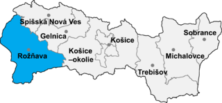
Kováčová is a village and municipality in the Rožňava District in the Košice Region of middle-eastern Slovakia.
Kożuszkowo is a village in the administrative district of Gmina Jeziora Wielkie, within Mogilno County, Kuyavian-Pomeranian Voivodeship, in north-central Poland.

Ciechanowczyk is a village in the administrative district of Gmina Ciechanowiec, within Wysokie Mazowieckie County, Podlaskie Voivodeship, in north-eastern Poland. It lies approximately 4 kilometres (2 mi) south-east of Ciechanowiec, 30 km (19 mi) south of Wysokie Mazowieckie, and 68 km (42 mi) south-west of the regional capital Białystok.

Çöpədərə is a village in the Zangilan Rayon of Azerbaijan.
Tądów Dolny is a village in the administrative district of Gmina Warta, within Sieradz County, Łódź Voivodeship, in central Poland. It lies approximately 8 kilometres (5 mi) north of Warta, 21 km (13 mi) north of Sieradz, and 57 km (35 mi) west of the regional capital Łódź.
Gołębiów is a village in the administrative district of Gmina Lipnik, within Opatów County, Świętokrzyskie Voivodeship, in south-central Poland. It lies approximately 3 kilometres (2 mi) east of Lipnik, 12 km (7 mi) south-east of Opatów, and 67 km (42 mi) east of the regional capital Kielce.
Przewóz is a village in the administrative district of Gmina Maciejowice, within Garwolin County, Masovian Voivodeship, in east-central Poland.
Chrzczanka-Folwark is a village in the administrative district of Gmina Długosiodło, within Wyszków County, Masovian Voivodeship, in east-central Poland.
Kamionka is a village in the administrative district of Gmina Mszczonów, within Żyrardów County, Masovian Voivodeship, in east-central Poland.
Daşkəsən is a settlement and municipality in the Dashkasan Rayon of Azerbaijan. It has a population of 823. The municipality consists of the settlement of Daşkəsən and the village of Aşağı Daşkəsən.
Kamionka is a village in the administrative district of Gmina Chojnice, within Chojnice County, Pomeranian Voivodeship, in northern Poland. It lies approximately 20 kilometres (12 mi) north of Chojnice and 91 km (57 mi) south-west of the regional capital Gdańsk.
Następowo is a village in the administrative district of Gmina Główczyce, within Słupsk County, Pomeranian Voivodeship, in northern Poland. It lies approximately 8 kilometres (5 mi) east of Główczyce, 36 km (22 mi) north-east of Słupsk, and 81 km (50 mi) west of the regional capital Gdańsk.
Topolno Wielkie is a village in the administrative district of Gmina Rychliki, within Elbląg County, Warmian-Masurian Voivodeship, in northern Poland. It lies approximately 4 kilometres (2 mi) north of Rychliki, 12 km (7 mi) south-east of Elbląg, and 69 km (43 mi) west of the regional capital Olsztyn.
Pilona is a village in the administrative district of Gmina Elbląg, within Elbląg County, Warmian-Masurian Voivodeship, in northern Poland. It lies approximately 8 kilometres (5 mi) east of Elbląg and 74 km (46 mi) north-west of the regional capital Olsztyn.

Xuân Sơn is a commune (xã) and village in Châu Đức District, Bà Rịa–Vũng Tàu Province, in Vietnam.
Badaguichiri is a village and rural commune in Niger.

Pavići is a village in the municipality of Banja Luka, Republika Srpska, Bosnia and Herzegovina.
Kaalepi is a village in Järva Parish, Järva County in northern-central Estonia.
Suurküla is a village in Märjamaa Parish, Rapla County in western Estonia.

Udovice is a village in the municipality of Smederevo, Serbia. According to the 2002 census, the village has a population of 2018 people.


