
India is the second most populated country in the world with a sixth of the world's population. According to official estimates, India's population stood at 1.38 billion.

Jammu and Kashmir was a region formerly administered by India as a state from 1954 to 2019, constituting the southern and southeastern portion of the larger Kashmir region, which has been the subject of a dispute between India, Pakistan and China since the mid-20th century. The underlying region of this state were parts of the former princely state of Jammu and Kashmir, whose western districts, now known as Azad Kashmir, and northern territories, now known as Gilgit-Baltistan, are administered by Pakistan. The Aksai Chin region in the east, bordering Tibet, has been under Chinese control since 1962.

Jharkhand is a state in eastern India. The state shares its border with the states of West Bengal to the east, Chhattisgarh to the west, Uttar Pradesh to the northwest, Bihar to the north and Odisha to the south. It has an area of 79,716 km2 (30,779 sq mi). It is the 15th largest state by area, and the 14th largest by population. Hindi is the official language of the state. The city of Ranchi is its capital and Dumka its sub-capital. The state is known for its waterfalls, hills and holy places; Baidyanath Dham, Parasnath, Dewri and Rajrappa are major religious sites. The state was formed on 15 November 2000, after carving out what was previously the southern half of Bihar.

Uttar Pradesh is a state in northern India. With over 200 million inhabitants, it is the most populated state in India as well as the most populous country subdivision in the world. It was established in 1950 after India had become a republic. It was a successor to the United Provinces (UP) during the period of the Dominion of India (1947–1950), which in turn was a successor to the United Provinces (UP) established in 1935, and eventually of the United Provinces of Agra and Oudh established in 1902 during the British Raj. The state is divided into 18 divisions and 75 districts, with the state capital being Lucknow, and Prayagraj serving as the judicial capital. On 9 November 2000, a new state, Uttaranchal, was created from Uttar Pradesh's western Himalayan hill region. The two major rivers of the state, the Ganges and its tributary Yamuna, meet at the Triveni Sangam in Prayagraj, a Hindu pilgrimage site. Other notable rivers are Gomti and Saryu. The forest cover in the state is 6.1 per cent of the state's geographical area. The cultivable area is 82 per cent of total geographical area and net area sown is 68.5 per cent of cultivable area.
Nashik is the largest city in the northern region of the Indian state of Maharashtra. Situated on the banks of river Godavari, Nashik is the fourth largest city in Maharashtra, after Mumbai, Pune and Nagpur. Nashik is well known for being one of the Hindu pilgrimage sites of the Kumbh Mela, which is held every 12 years. Nashik is located about 190 km north of state capital Mumbai. The city is called the "Wine Capital of India" as more than half of India's vineyards and wineries are located here. Around 90% of all wine produced in India comes from the Nashik Valley.
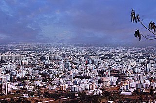
Bangalore Urban district, is the most densely populated district in the Indian state of Karnataka. It is surrounded by the Bangalore Rural district on the east and north, the Ramanagara district on the west and the Krishnagiri district of Tamil Nadu on the south. Bangalore Urban district came into being in 1986, with the partition of the erstwhile Bangalore district into Bangalore Urban and Bangalore Rural districts. Bangalore Urban has five taluks: Hebbala, Kengeri, Krishnarajapura, Yelahanka and Anekal. The city of Bangalore is situated in the Bangalore Urban district and is the headquarters of the district. The district has 2 divisions, 5 talukas, 17 hoblies, 872 villages, 11 rural habitations, 5 towns, 1 tier-three city and 1 tier-one city, administered by 96 Village Panchayats 97 Taluk Panchayats , 5 Town Municipal Councils (Purasabes), 1 City Municipal Council (Nagarasabe) and 1 City Corporation .

Kottayam, IPA: [koːʈːɐjɐm] is a city in the Indian state of Kerala. Flanked by the Western Ghats on the east and the Vembanad Lake and paddy fields of Kuttanad on the west, Kottayam is a place that is known for extraordinary qualities. It is the district headquarters of Kottayam district, located in south-west Kerala. Kottayam is located in the basin of the Meenachil River at an average elevation of 3 metres (9.8 ft) above sea level, and has a moderate climate. It is located approximately 155 kilometres (96 mi) north of the state capital Thiruvananthapuram.

Kupwara district, Kupwara is one of the 10 districts located in the Kashmir Valley region of Jammu and Kashmir, India. The talri river( originating in lolab valley and flowing from east to west) and Mawar river are two main rivers in the district. Both of them meet Jhelum river in Baramulla district.

Indas is a community development block that forms an administrative division in the Bishnupur subdivision of the Bankura district in the Indian state of West Bengal.

Patrasayer is a community development block that forms an administrative division in the Bishnupur subdivision of the Bankura district in the Indian state of West Bengal.
Hirbandh is a community development block that forms an administrative division in the Khatra subdivision of the Bankura district in the Indian state of West Bengal.

The 2011 Census of India or the 15th Indian Census was conducted in two phases, house listing and population enumeration. The House listing phase began on 1 April 2010 and involved the collection of information about all buildings. Information for National Population Register (NPR) was also collected in the first phase, which will be used to issue a 12-digit unique identification number to all registered Indian residents by Unique Identification Authority of India. The second population enumeration phase was conducted between 9 and 28 February 2011. Census has been conducted in India since 1872 and 2011 marks the first time biometric information was collected. According to the provisional reports released on 31 March 2011, the Indian population increased to 1.21 billion with a decadal growth of 17.70%. Adult literacy rate increased to 74.04% with a decadal growth of 9.21%. The motto of the census was 'Our Census, Our future'.

Pakistanis are the citizens and nationals of the Islamic Republic of Pakistan. According to the 2017 Pakistani national census, the population of Pakistan stood at over 213 million people, making it the world's fifth-most populous country. The majority of Pakistanis natively speak languages belonging to the Indo-Aryan and Iranian language families.
Barjora is a community development block that forms an administrative division in the Bankura Sadar subdivision of the Bankura district in the Indian state of West Bengal.

Jammu and Kashmir is a region administered by India as a union territory and consists of the southern portion of the larger Kashmir region, which has been the subject of a dispute between India and Pakistan since 1947, and between India and China since 1962. The Line of Control separates Jammu and Kashmir from the Pakistani-administered territories of Azad Kashmir and Gilgit-Baltistan in the west and north. It lies to the north of the Indian states of Himachal Pradesh and Punjab and to the west of Ladakh, which is also subject to the dispute as a part of Kashmir, and administered by India as a union territory.
Kolathur is a neighborhood located in the northwestern region of Chennai, India.

