
Wood County is a county located in the U.S. state of Wisconsin. As of the 2010 census, the population was 74,749. Its county seat is Wisconsin Rapids. The county is named after Joseph Wood, a member of the Wisconsin State Assembly.

Lake Holcombe is a town in Chippewa County in the U.S. state of Wisconsin. Its population was 1,031 at the 2010 census. The census-designated place of Holcombe is located in the town.

Mercer is a town in southern Iron County, Wisconsin, United States. The population was 1,732 at the 2000 census. The census-designated place of Mercer and the unincorporated communities of Carter and Manitowish are located within the town.

The Chippewa River in Wisconsin flows approximately 183 miles (294 km) through west-central and northwestern Wisconsin. It was once navigable for approximately 50 miles (80 km) of its length, from the Mississippi River, by Durand, northeast to Eau Claire. Its catchment defines a portion of the northern boundary of the Driftless Area. The river is easily accessible for bikers and pleasure seekers via the Chippewa River State Trail which follows the river from Eau Claire to Durand.
The Couderay River is a tributary of the Chippewa River in northwestern Wisconsin in the United States. Via the Chippewa River, it is part of the Mississippi River watershed. It flows for its entire length in Sawyer County. Its name is derived from the French "Rivière des Courte Oreilles".

The Flambeau River is a tributary of the Chippewa River in northern Wisconsin, United States. The Chippewa is in turn a tributary of the upper Mississippi River. The Flambeau drains an area of 1,860 square miles (4,800 km2) and descends from an elevation of approximately 1,570 feet (480 m) to 1,060 feet (320 m) above sea level. The Flambeau is an important recreational destination in the region. It is notable among canoeists in the Midwest for outstanding canoe camping, including excellent scenery, fishing and whitewater. The river and its forks have a variety of possible trip lengths from short day outings, to overnight camping, to voyages of a week or more.
The Little River is a short river in Maine. From the outflow of Little River Lake in T.47 MD BPP, the river runs 7.1 miles (11.4 km) southeast and northeast to Big Lake in T.27 ED BPP.
Mercer is an unincorporated census-designated place located in the town of Mercer, Iron County, Wisconsin, United States. Mercer is located on U.S. Route 51 20.5 miles (33.0 km) south-southeast of Hurley. Mercer has a post office with ZIP code 54547. As of the 2010 census, its population is 516.

Nelson Lake is a reservoir in Sawyer County, Wisconsin formed by a dam across the Totagatic River.

The Spirit River is a tributary of the Wisconsin River with headwaters in Price County and a confluence with the Wisconsin in Lincoln County just downstream from Lake Mohawksin. The source is Spirit Lake near Timms Hill. The Ojibwe name for the river was Manatokikewe Sebe . The river flows nearly west to east. About one mile from its mouth, the Wisconsin Valley Improvement Company maintains a dam which forms the Spirit River Flowage.

Swamp Creek is a tributary of the Flambeau River in northern Wisconsin, USA. The Flambeau is in turn a tributary of the Chippewa River.
The Turtle-Flambeau Flowage is a 12,942 acres (52.37 km2) lake, in Iron County, Wisconsin. It has a maximum depth of 15 meters and is the seventh largest lake in the state of Wisconsin by surface area. The flowage is home to unique wetland patterns and plant species as well as several species of sport and game fish, including Musky, Panfish, Largemouth Bass, Smallmouth Bass, Northern Pike, Walleye and Sturgeon. The lake's water clarity is low, but can vary in different locations in the lake. Fishing, camping, boating, and hunting are popular activities on the flowage, and Ojibwe people traditionally harvest fish and game on the lake. Environmental concerns on the flowage include mercury contamination, algal blooms, and several types of invasive species.
The Willow Reservoir or Willow Flowage is an artificial lake in Oneida County, Wisconsin formed by a dam on the Tomahawk River. The dam and reservoir level are controlled by the Wisconsin Valley Improvement Company as part of regulating the overall flow of the upper Wisconsin River. When full, Willow Reservoir has a surface area of 6306 acres.

The Jersey City Flowage is an artificial lake on the Tomahawk River, located about one mile above the confluence with the Wisconsin River in Tomahawk, Wisconsin. The dam and the flow are controlled by the Wisconsin Valley Improvement Company. The dam was originally built in 1910 to provide power for a tannery.Jersey City Flowage is a 423 acre lake located in Lincoln County. It has a maximum depth of 20 feet.
The Willow River is a river in Oneida County, Wisconsin, that merges with the Tomahawk River by way of the Willow Flowage. Historically the Willow River was a significant white pine logging region.

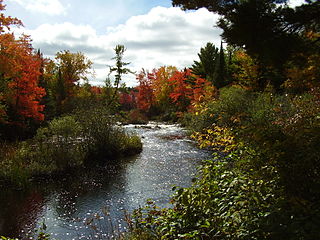
The Manitowish River is a river in Vilas County and Iron County in the state of Wisconsin in the United States. Its source is Fishtrap Lake near Boulder Junction. The conjunction of the Manitowish River and the Bear River is the source of the north fork of the Flambeau River. Historically the Manitowish River was an important part of an extensive network of canoe routes linked by short land portages, used by the Ojibwe and fur traders. In modern times the river and the lakes it connects are popular recreational waterways.
Lake Chippewa, also known as Chippewa Flowage, is an artificial lake in northwestern Wisconsin. It is fed by the East Fork Chippewa River and the West Fork Chippewa River. Winter Dam at the southern end is where the Chippewa River flows out of the lake.
Wilson Lake is located in Iron County, outside of Wilson Creek Flowage. It is one of seven lakes in the state with the name Wilson Lake. This particular lake is a popular fishing lake 5 miles (8.0 km) from the town of Mercer. With three bays, it has two islands and water feed and drain in the South Bay of the lake. The public boat landing is in the Main Bay on the west side of the lake. The North Bay has the most marsh vegetation. There are many cabins located on the lake for residents and vacationers to the North Woods.
