
The second USS Ohio was a ship of the line of the United States Navy, rated at 74 guns, although her total number of guns was 104. She was designed by Henry Eckford, laid down at Brooklyn Navy Yard in 1817, and launched on 30 May 1820. She went into ordinary and in the ensuing years decayed badly. Refitted for service in 1838, Ohio sailed on 16 October 1838 to join the Mediterranean Squadron under Commodore Isaac Hull. Acting as flagship for two years, she protected commerce and suppressed the slave trade off the African coast. Ohio proved to have excellent performance under sail, repeatedly making more than 12 kn. One of her officers stated, "I never supposed such a ship could be built—a ship possessing in so great a degree all the qualifications of a perfect vessel." In 1840, Ohio returned to Boston, where she again went into ordinary. From 1841 to 1846, Ohio served as receiving ship.

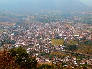
Tuxpan is both a municipality and city located in the Mexican state of Veracruz. The population of the city was 78,523 and of the municipality was 134,394 inhabitants, according to the INEGI census of 2005, residing in a total area of 1,051.89 km2 (406.14 sq mi). The municipality includes many smaller outlying communities, the largest of which are Alto Lucero and Santiago de la Peña. A local beachside community is also nearby.

USS Albany, the first United States Navy ship of that name, was built in the 1840s for the US Navy. The ship was among the last of the wooden sloops powered by sail and saw extensive service in the Mexican War. Before and after her combat service, Albany conducted surveillance and observation missions throughout the Caribbean. In September 1854, during a journey along the coast of Venezuela, Albany was lost with all hands on 28 or 29 September 1854. Included among the 250 men lost were several sons and grandsons of politically prominent men.
Tuxpan is a municipality and city in Veracruz, Mexico.
The First Battle of Tuxpan was the only major battle fought during the Mexican–American War at Tuxpan, Mexico.
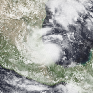
Hurricane Debby was the first hurricane to strike the Mexican state of Veracruz since Hurricane Anna in 1956. The eighth tropical cyclone, fourth named storm, and the first hurricane of the 1988 Atlantic hurricane season, Debby developed from a tropical wave off the west coast of the Yucatan Peninsula on August 31. The system slowly intensified as it tracked west-northwestward toward Mexico, eventually reaching tropical storm status on September 2. Thereafter, Debby began to rapidly strengthen, and the storm was upgraded to a hurricane later that day. After attaining peak winds of 75 mph (120 km/h), Debby made landfall near Tuxpan, Veracruz, in Mexico early on September 3. The hurricane quickly weakened inland, but managed to reach the eastern Pacific on September 5. Debby became Tropical Depression Seventeen-E, which moved northwest but remained poorly organized due to wind shear and dissipated on September 8.
Tuxpan River may refer to:
Tuxpan is a small village in between Zitácuaro and Ciudad Hidalgo in the Mexican state of Michoacán. It is located 118 km (73 mi) from Morelia.
Tuxpan is a town and municipality in the Mexican state of Jalisco. The name "Tuxpan" comes from the Nahuatl word tochpan, a word used to describe where rabbits live or possibly place of abundant rabbits. Some others translate it as a location above the river.

Tihuatlán Municipality is a municipality located in the north zone in the State of Veracruz, about 316 km from state capital Xalapa. It has a surface of 828.29 km2. The name comes from the language Náhuatl, Cihua-tlán; that means “Women’s place " but refers to gods.

The Tuxpan River in Mexico flows into the Gulf of Mexico near the city and port of Tuxpan in the state of Veracruz. Its principal sources are the Vinazco River, which rises in Hidalgo, and the Pantepec River, which rises in Puebla, both of which enter the territory of Veracruz before the city of Álamo, in Temapache Municipality, uniting to form the Tuxpan, which has become an important passage for harbor access, strengthening the region's economy. Passing the city of Tuxpan it forms the lagoon of Tampamachoco close to its mouth.
The Pantepec River is a river of Mexico that belongs to the Tuxpan River basin, on the Gulf of Mexico slope. The Pantepec River is considered the upper course of the Tuxpan River.
See the First Battle of Tuxpan.
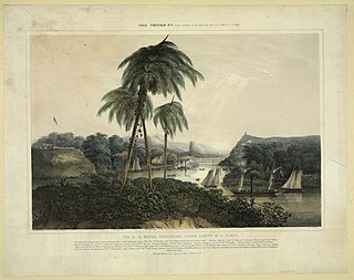
The Third Battle of Tuxpan was one of the three small battles of the Mexican–American War to occur in Tuxpan, Mexico. The engagement occurred on June 30, 1847, between Mexican troops and or militia and an American landing force from the Mosquito Fleet under Matthew C. Perry. Not much is known but a skirmish was fought, ending in the deaths of one U.S. man, and another who died two or three days later. Five other men were wounded, not including the said sixth man who died later on. At least four of the wounded Americans were made casualties by a gunpowder barrel explosion, caused by an unknown source. Mexican casualties are unknown. The United States blockade of Tuxpan continued on.

Jürgen Damm Rascón is a Mexican professional footballer who plays as a winger for Major League Soccer club Atlanta United.
Tuxpan Municipality is a municipality located in the Mexican state of Veracruz.
Federal Highway 130D is a toll highway connecting Tuxpan, Veracruz to Gutiérrez Zamora, Veracruz. Its northern portion serves as the northern terminus of the México-Tuxpan highway corridor. The route is maintained and operated by Caminos y Puentes Federales.
Federal Highway 132D is the designation for toll highways paralleling Mexican Federal Highway 132. Highway 132D forms most of the Mexico City-Tuxpan highway corridor, with contiguous segments in the State of Mexico and from Tulancingo, Hidalgo to Tihuatlán, Veracruz.

Tepetzintla is a municipality in the Mexican state of Veracruz, located 207 kilometres (129 mi) northwest of the state capital of Xalapa and 119 kilometres (74 mi) south of the city of Tampico.
