Dnestrovsc is a town in southern Transnistria, Moldova, near the border with Ukraine. It is at the shores of the Cuciurgan Reservoir and is home to the Kuchurgan power station, also known as Moldavskaya GRES.

Goicea is a commune in Dolj County, Oltenia, Romania. Its existence was first attested in 1575. It is composed of two villages, Dunăreni and Goicea. It also included Cârna village until 2004, when it was split off to form a separate commune.
Minh Long is a district (huyện) of Quảng Ngãi Province in the South Central Coast region of Vietnam.
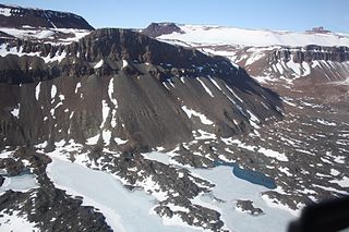
Mount Alford is a flat-topped, ice-free mountain (1,480 m) at the south side of Boggs Valley in the Helliwell Hills. Mapped by United States Geological Survey (USGS) from surveys and U.S. Navy air photos, 1960-63. Named by Advisory Committee on Antarctic Names (US-ACAN) for Montague Alford, United States Antarctic Research Program (USARP) geologist at McMurdo Station, 1967-68. The mountain is situated on the Pennell Coast, a portion of Antarctica lying between Cape Williams and Cape Adare.

Boggs Valley is a glaciated valley, heavily strewn with morainal debris, which indents the east side of the Helliwell Hills between Mount Van der Hoeven and Mount Alford, Victoria Land, Antarctica. The geographical feature was first mapped by the United States Geological Survey from surveys and from U.S. Navy air photos, 1960–63, and named by the Advisory Committee on Antarctic Names for William J. Boggs, United States Antarctic Research Program biologist who performed his biological observations while situated at McMurdo Station, Hut Point Peninsula, Ross Island, during the summer of 1967–68. The valley lies situated on the Pennell Coast, a portion of Antarctica lying between Cape Williams and Cape Adare.
Bowsprit Moraine is a medial moraine, 1.5 nautical miles (2.8 km) long, off the northeast point of Elkhorn Ridge, where Towle Glacier and Northwind Glacier join Fry Glacier, in the Convoy Range, Victoria Land. It is one of a group of nautical names in Convoy Range: the mapped form of the moraine protrudes like a bowsprit out from the end of Elkhorn Ridge. It was named by a 1989–90 New Zealand Antarctic Research Programme field party.

Mushketov Glacier is a large glacier trending northeastward, draining the area between the Wohlthat Mountains on the west and the Weyprecht, Payer and Lomonosov Mountains on the east, in Queen Maud Land. Discovered and plotted from air photos by German Antarctic Expedition, 1938-39. Replotted from air photos and surveys by Soviet Antarctic Expedition, 1958–59, and named after Ivan V. Mushketov (1850–1902), Russian geologist and geographer.
Furdesanden Moraine is a moraine extending in a north–south direction for 17 nautical miles (31 km) along the west side of the Conrad Mountains in the Orvin Mountains of Queen Maud Land, Antarctica. It was discovered and photographed by the Third German Antarctic Expedition, 1938–39. It was mapped by Norway from air photos and surveys by the Sixth Norwegian Antarctic Expedition, 1956–60, and named Furdesanden.

Vinje Glacier is a broad glacier about 20 nautical miles (37 km) long flowing northwest between the Filchner Mountains and Fenriskjeften Mountain in Queen Maud Land. Mapped by Norwegian cartographers from surveys and air photos by the Norwegian Antarctic Expedition (1956–60) and named for T. Vinje, meteorologist with Norwegian Antarctic Expedition (1956–58).
Cape Errera is a cape which forms the southwest end of Wiencke Island, in the Palmer Archipelago. It was discovered by the Belgian Antarctic Expedition, 1897–99, and named by Gerlache for Leo Errera, Paul Errera, and Madame M. Errera, contributors to the expedition.

Gjel Glacier is a glacier, 17 nautical miles (31 km) long, flowing north between the steep cliffs of the Luncke Range and Mefjell Mountain, in the Sør Rondane Mountains of Antarctica. It was mapped by Norwegian cartographers in 1957 from air photos taken by U.S. Navy Operation Highjump, 1946–47, and named Gjelbreen.
Moraine Valley is a valley filled with morainic debris, 0.75 nautical miles (1.4 km) long, which drains north into Elephant Flats on the east side of Signy Island, in the South Orkney Islands off Antarctica. In summer a stream, fed by the ice slopes at its south end, runs in this valley. It was named by the Falkland Islands Dependencies Survey following their survey of 1947.
The Løken Moraines are a line of north-south trending moraines, about 7 nautical miles (13 km) long, lying from 0.5 to 2 nautical miles inland from the Windmill Islands off Antarctica, just east of the bases of Clark, Bailey and Mitchell Peninsulas. The moraines were first mapped from air photos taken by U.S. Navy Operation Highjump (1946–47) and Operation Windmill (1947–48), and were named by Carl R. Eklund for Olav Løken, a Norwegian glaciologist who was a member of the Wilkes Station party, 1957.
Humboldt Graben is a glacier-filled valley, 20 nautical miles (37 km) long, trending north–south between the Humboldt Mountains and the Petermann Ranges in Queen Maud Land, Antarctica. The feature was discovered and mapped by the Third German Antarctic Expedition under Alfred Ritscher, 1938–39, who named it in association with the adjacent Humboldt Mountains.

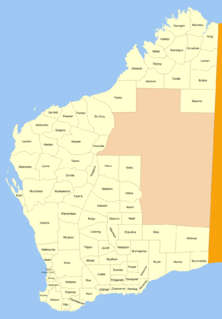
Fitzgerald Land District is a land district of Western Australia, located within the Eucla Land Division inland from Esperance. It spans roughly 32°35'S - 33°15'S in latitude and 121°00'E - 122°15'E in longitude.
Smalegga Spur is a small rock spur 3 nautical miles (6 km) south-southeast of Morkenatten Peak, Shcherbakov Range, in the Orvin Mountains of Queen Maud Land. Mapped by Norway from air photos and surveys by Norwegian Antarctic Expedition, 1956–60, and named Smalegga.
Spraglegga Ridge is a ridge that is partly rock and partly covered by snow, surmounted by Stenka Mountain, standing 4.5 nautical miles (8 km) southeast of Kvaevefjellet Mountain in the Payer Mountains, Queen Maud Land. Discovered and plotted from air photos by German Antarctic Expedition, 1938-39. Replotted from air photos and surveys by Norwegian Antarctic Expedition, 1956 60, and named Spraglegga.
Rampart Ridge is a prominent broken ridge on the west side of the Royal Society Range, standing north of Rutgers Glacier and extending from The Spire to Bishop Peak. Surveyed and given this descriptive name in February 1957 by the New Zealand Northern Survey Party of the Commonwealth Trans-Antarctic Expedition, 1956-58.


![]()


