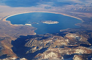
Mono Lake is a saline soda lake in Mono County, California, formed at least 760,000 years ago as a terminal lake in an endorheic basin. The lack of an outlet causes high levels of salts to accumulate in the lake and make its water alkaline.

Mono County is a county located in the east central portion of the U.S. state of California. As of the 2010 census, the population was 14,202. making it the fifth-least populous county in California. The county seat is Bridgeport. The county is located east of the Sierra Nevada between Yosemite National Park and Nevada. The only incorporated town in the county is Mammoth Lakes, which is located at the foot of Mammoth Mountain. Other locations, such as June Lake, are also famous as skiing and fishing resorts. Located in the middle of the county is Mono Lake, a vital habitat for millions of migratory and nesting birds. The lake is located in a wild natural setting, with pinnacles of tufa arising out of the salty and alkaline lake. Also located in Mono County is Bodie, the official state gold rush ghost town, which is now a California State Historic Park.
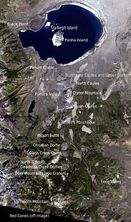
The Mono–Inyo Craters are a volcanic chain of craters, domes and lava flows in Mono County, Eastern California. The chain stretches 25 miles (40 km) from the northwest shore of Mono Lake to the south of Mammoth Mountain. The Mono Lake Volcanic Field forms the northernmost part of the chain and consists of two volcanic islands in the lake and one cinder cone volcano on its northwest shore. Most of the Mono Craters, which make up the bulk of the northern part of the Mono–Inyo chain, are phreatic volcanoes that have since been either plugged or over-topped by rhyolite domes and lava flows. The Inyo volcanic chain form much of the southern part of the chain and consist of phreatic explosion pits, and rhyolitic lava flows and domes. The southernmost part of the chain consists of fumaroles and explosion pits on Mammoth Mountain and a set of cinder cones south of the mountain; the latter are called the Red Cones.

The California water wars were a series of political conflicts between the city of Los Angeles and farmers and ranchers in the Owens Valley of Eastern California over water rights.
Horseshoe Lake may refer to:
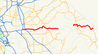
State Route 120 is a state highway in the U.S. state of California, running west to east across the central part of the state. It runs from Interstate 5 in the San Joaquin Valley near Lathrop through Yosemite National Park, to its end at U.S. Route 6 in Mono County, eastern California. While the route is signed as a contiguous route through Yosemite National Park, the portion in park boundaries is federally maintained, and is not included in the state route logs. The portion at Tioga Pass is the highest paved through road in the California State Route system. This part is not maintained in the winter and is usually closed during the winter season.
Lake Mary or Mary Lake may refer to:

The Mono are a Native American people who traditionally live in the central Sierra Nevada, the Eastern Sierra, the Mono Basin, and adjacent areas of the Great Basin. They are often grouped under the historical label "Paiute" together with the Northern Paiute and Southern Paiute - but these three groups, although related within the Numic group of Uto-Aztecan languages, do not form a single, unique, unified group of Great Basin tribes.
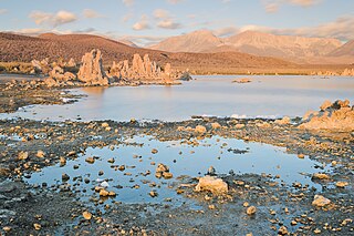
Mono Lake Tufa State Natural Reserve is located near Yosemite National Park within Mono County, in eastern California. It was established in 1981 by the California State Legislature to preserve the natural limestone "tufa tower" formations at Mono Lake.

Inyo National Forest is a United States National Forest covering parts of the eastern Sierra Nevada of California and the White Mountains of California and Nevada. The forest hosts several superlatives, including Mount Whitney, the highest point in the contiguous United States; Boundary Peak, highest point in Nevada; and the Ancient Bristlecone Pine Forest that protects the oldest trees in the world. The forest, encompassing much of Owens Valley, was established by Theodore Roosevelt as a way of sectioning off land to accommodate the Los Angeles Aqueduct project in 1907, making the Inyo National Forest one of the least wooded forests in the United States' system.

Mono Village is a community in Mono County, California. It is located 11 miles (18 km) southwest of Bridgeport, at an elevation of 7142 feet. It is part of the Twin Lakes census-designated place.

The Kucadikadi are a band of Northern Paiute people who live near Mono Lake in Mono County, California. They are the southernmost band of Northern Paiute.
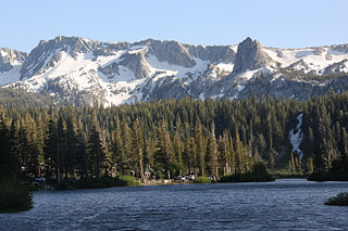
Twin Lakes is a set of connected lakes at the base of the southeastern slope of Mammoth Mountain, in Mono County of eastern California. They are in the eastern Sierra Nevada, and within the Inyo National Forest.
Alpine lake is a class of lakes found at high altitudes.
Twin Lakes in Mono County, California can refer to:

Twin Lakes is a pair of lakes approximately 9 miles (14 km) southwest of the town of Bridgeport in Mono County, California. Mono Village resorts lie along the lakeside. The communities around the lake are part of the Twin Lakes census-designated place.
Twin Lakes is a census-designated place (CDP) in Mono County, California, United States. It is located on the east side of the Sierra Nevada, encompassing the lakes of the same name and extending north down the outlet valley of Robinson Creek. The community of Mono Village is within the CDP. The area is part of Toiyabe National Forest and is 10 miles (16 km) southwest of Bridgeport. It was first listed as a CDP prior to the 2020 census.
This page is based on this
Wikipedia article Text is available under the
CC BY-SA 4.0 license; additional terms may apply.
Images, videos and audio are available under their respective licenses.