The Pacific Crest Trail (PCT), officially designated as the Pacific Crest National Scenic Trail, is a long-distance hiking and equestrian trail closely aligned with the highest portion of the Cascade and Sierra Nevada mountain ranges, which lie 100 to 150 miles east of the U.S. Pacific coast. The trail's southern terminus is next to the Mexico–United States border, just south of Campo, California, and its northern terminus is on the Canada–US border, upon which it continues unofficially to the Windy Joe Trail within Manning Park in British Columbia; it passes through the states of California, Oregon, and Washington.

McArthur–Burney Falls Memorial State Park is the second oldest state park in the California State Parks system, located approximately 6 miles (9.7 km) north of Burney, California. The park offers camping, fishing, watersports, hiking and horseback riding facilities. The park is mainly known for the waterfall, Burney Falls, at the entrance of the park. Wildlife in the park includes bass, trout, Steller's jay, squirrels, woodpeckers, deer, and on rare occasion, black bear.

The American Discovery Trail is a system of recreational trails and roads that collectively form a coast-to-coast hiking and biking trail across the mid-tier of the United States. Horses can also be ridden on most of this trail. The coastal trailheads are the Delmarva Peninsula on the Atlantic Ocean and the northern California coast on the Pacific Ocean. The trail has northern and southern alternates for part of its distance, passing through Chicago and St. Louis respectively. The total length of the trail, including both the north and south routes, is 6,800 miles (10,900 km). The northern route covers 4,834 miles (7,780 km) with the southern route covering 5,057 miles (8,138 km). It is the only non-motorized coast-to-coast trail.

Donner Lake, formerly known as Truckee Lake, is a freshwater lake in Northeast California on the eastern slope of the Sierra Nevada and about 20 miles (32 km) northwest of the much larger Lake Tahoe. A moraine serves as a natural dam for the lake. The lake is located in the town of Truckee, between Interstate 80 to the north and Schallenberger Ridge to the south. The tracks of the Union Pacific Railroad run along Schallenberger Ridge and closely follow the route of the original transcontinental railroad. The historic route of the Lincoln Highway, the first automobile road across America and US 40 follows the northern shoreline, then climbs to Donner Pass from where the entire lake may be viewed.

Tenaya Lake is an alpine lake in Yosemite National Park, located between Yosemite Valley and Tuolumne Meadows. The surface of Tenaya Lake has an elevation of 8,150 feet (2,484 m). The lake basin was formed by glacial action, which left a backdrop of light granite rocks, whose beauty was known to the Native Americans. Today, Tenaya Lake is easily accessible by State Route 120 and is a popular lake for water activities.
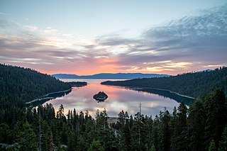
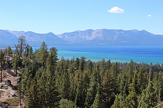
Emerald Bay State Park is a state park of California in the United States, centered on Lake Tahoe's Emerald Bay, a National Natural Landmark. Park features include Eagle Falls and Vikingsholm, a 38-room mansion that is considered one of the finest examples of Scandinavian architecture in the United States. The architect was Leonard Palme, who was hired by his aunt Lora Josephine Knight to design and build Vikingsholm. The park contains the only island in Lake Tahoe, Fannette Island. The park is accessible by California State Route 89 near the southwest shore of the lake. Emerald Bay is one of Lake Tahoe's most photographed and popular locations.

Clear Lake State Park is a state park of California, United States, on Clear Lake. The park is popular for water recreation. Amenities include 149 developed campsites spread across four campground areas, two group campsites, a swimming beach with showers, a boat launch, and a marina. Since the area is a major breeding ground for grebes, there's a broad "no wake" zone in the Cole Creek launch area and near the reedy shoreline, which is conducive to canoeing and kayaking. The 590-acre (240 ha) park was established in 1949.

Ostrander Lake is located in Yosemite National Park, approximately 10 miles (16 km) south of Yosemite Valley and 10 miles (16 km) east of the Badger Pass Ski Area, at an elevation of 8,500 feet (2,600 m). The lake is a popular destination for cross-country skiers during the winter. It is the primary source of Bridalveil Creek, which feeds Bridalveil Falls.
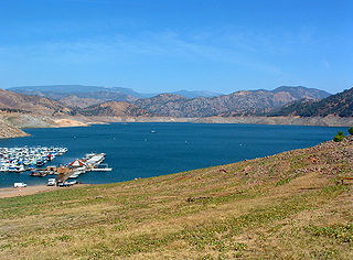
Pine Flat Lake is an artificial lake or reservoir in the Sierra Nevada foothills of eastern Fresno County, California on the western north-south border to the Sierra- and Sequoia National Forests, about 30 mi (48 km) east of Fresno. The lake is managed by the U.S. Army Corps of Engineers (USACE) and is open to boaters, campers & hikers.

The Whiskeytown–Shasta–Trinity National Recreation Area is a United States National Recreation Area in northern California. The recreation area was authorized in 1965 by the United States Congress. Recreational activities available include swimming, fishing, boating, camping, and hiking.

Lake Perris is an artificial lake completed in 1973. It is the southern terminus of the California State Water Project, situated in a mountain-rimmed valley between Moreno Valley and Perris, in what is now the Lake Perris State Recreation Area. The park offers a variety of recreational activities. Because of this and the lake's proximity to major population centers, it is very crowded during the summer months.

Mount Tallac is a mountain peak southwest of Lake Tahoe, in El Dorado County, California. The peak lies within the Desolation Wilderness in the Eldorado National Forest. It is quite visible from State Routes 89 and 28, and U.S. Route 50. A "cross of snow" is clearly visible on the mountain's face during the winter, spring, and early summer months.

Silverwood Lake is a large reservoir in San Bernardino County, California, United States, located on the West Fork Mojave River, a tributary of the Mojave River in the San Bernardino Mountains. It was created in 1971 as part of the State Water Project by the construction of the Cedar Springs Dam as a forebay on the 444 mi (715 km) long California Aqueduct, and has a capacity of 73,000 acre⋅ft (90,000,000 m3).

Jennie Lakes Wilderness is a protected area in the Sierra Nevada, in Tulare County, California. It is located 60 miles (97 km) east of Fresno and managed by the US Forest Service. Jennie Lakes Wilderness is about nine square miles within the Sequoia National Forest, that was established by the California Wilderness Act of 1984, and added to the National Wilderness Preservation System.

Lake Oroville State Recreation Area (LOSRA) is a state park unit of California, United States, surrounding Lake Oroville, a reservoir on the Feather River. It is located in Butte County outside Oroville, California. The 29,447-acre (11,917 ha) park was established in 1967. The recreation area "includes Lake Oroville and the surrounding lands and facilities within the project area as well as the land and waters in and around the Diversion Pool and Thermalito Forebay, downstream of Oroville Dam."

The Dinkey Lakes Wilderness is a federally designated wilderness area located 45 miles (72 km) northeast of Fresno, in the state of California, United States. It comprises 30,000 acres (12,141 ha) within the Sierra National Forest and was added to the National Wilderness Preservation System by the California Wilderness Act of 1984. Elevations range from 8,200 feet (2,500 m) to 10,619 feet (3,237 m). Recreational activities in the wilderness include day hiking, backpacking, horseback riding, fishing, rock climbing and cross-country skiing.
The Rawhide Mountains are a mountain range of western Arizona, in the southwest of Mohave County. It is part of a block of mountain ranges on the north of an insular region called the Maria fold and thrust belt, containing mountain ranges, valleys, and plains. The Rawhide Mountains border the much smaller Artillery Mountains southeast, bordering on Alamo Lake State Park and the south-flowing Big Sandy River.
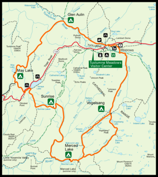
The High Sierra Camps are nine rustic lodging facilities located in two national parks and a national monument in California's Sierra Nevada mountain range. Open most years from June or July to September, they are staffed camps with tent cabins and food service facilities. The backcountry camps receive their supplies by pack mules.
Van Sickle Bi-State Park is a public recreation area straddling the border of California and Nevada, United States, that overlooks Lake Tahoe and preserves the memory of Henry Van Sickle, a key member in the founding of Genoa and the surrounding area. The state park features trails for hiking, mountain biking, and horseback riding. It is managed by the Nevada Division of State Parks in partnership with the California Tahoe Conservancy.
