
Bath and North East Somerset (B&NES) is a unitary authority district in England. Bath and North East Somerset Council was created on 1 April 1996 following the abolition of the county of Avon. It is part of the ceremonial county of Somerset.

Keynsham is a town and civil parish located between Bristol and Bath in Somerset, England. It has a population of 16,000. It was listed in the Domesday Book as Cainesham, which is believed to mean the home of Saint Keyne.

The Cotswold Way is a 102-mile (164 km) long-distance footpath, running along the Cotswold Edge escarpment of the Cotswold Hills in England. It was officially inaugurated as a National Trail on 24 May 2007 and several new rights of way have been created.
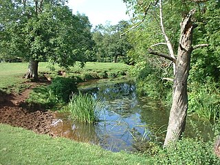
The River Chew is a small river in England that flows for some 17 miles (27 km) through the North Somerset countryside to form the Chew Valley before merging with the River Avon.

Pensford is the largest village in the civil parish of Publow in Somerset, England. It lies in the affluent Chew Valley, approximately 7 miles (11 km) south of Bristol, 8 miles (13 km) west of Bath and 14 miles (23 km) north of Wells. It is on the A37 road from Bristol to Shepton Mallet.

The Monarch's Way is a 625-mile (1,006 km) long-distance footpath in England that approximates the escape route taken by King Charles II in 1651 after being defeated in the Battle of Worcester. It runs from Worcester via Bristol and Yeovil to Shoreham, West Sussex.

The Stour Valley Way is a 64-mile (103 km) long-distance footpath in southern England. From Stourton, Wiltshire, the path travels southeast through Dorset to Hengistbury Head near Christchurch.

The Chew Valley is an affluent area in North Somerset, England, named after the River Chew, which rises at Chewton Mendip, and joins the River Avon at Keynsham. Technically, the area of the valley is bounded by the water catchment area of the Chew and its tributaries; however, the name Chew Valley is often used less formally to cover other nearby areas, for example, Blagdon Lake and its environs, which by a stricter definition are part of the Yeo Valley. The valley is an area of rich arable and dairy farmland, interspersed with a number of villages.

Norton Malreward is a small Somerset village and civil parish 4 miles (6.4 km) south of Bristol, England at the northern edge of the Chew Valley. In 1895 Norton Malreward was combined with the neighbouring hamlet of Norton Hawkfield into a single parish, which has a population of 246.
Compton Dando is a small village and civil parish on the River Chew in the affluent Chew Valley in England. It is in the Bath and North East Somerset council area and ceremonial county of Somerset, and lies 7 miles (11.3 km) from Bristol, 8 miles (12.9 km) from Bath, and 3 miles (4.8 km) from Keynsham.

Chewton Keynsham is a hamlet on the River Chew in the Chew Valley, Somerset. It is 7 miles from Bristol, 7 miles from Bath, and 2 miles (3.2 km) south of the centre of the town of Keynsham.

Woollard is a small village on the River Chew in the affluent Chew Valley in England. It is in the Bath and North East Somerset council area and the ceremonial county of Somerset. The village is 7 miles (11 km) from Bristol, 9 miles (14 km) from Bath, and 4 miles (6.4 km) from Keynsham.

The Viking Way is a long distance trail in England running 147 miles (237 km) between the Humber Bridge in North Lincolnshire and Oakham in Rutland.

Chew Valley in Saddleworth, Greater Manchester, England, follows the course of Chew Brook on the western slopes of Black Chew Head to where it joins the River Tame at Greenfield, east of Manchester. Part of the higher fringes of the valley towards the peak of Black Chew Head lie across the boundary in Derbyshire. The eastern part of the valley including the reservoirs of Dovestone and Chew are within the north western extremity of the Peak District National Park.
The Mendip Way is an 80-kilometre (50 mi) long-distance footpath across the Mendip Hills from Weston-super-Mare to Frome. It is divided into two sections.
The Celtic Way is a long-distance walk from West Wales, through South Wales and into Wessex and the West of England in the United Kingdom. The route is 725-mile-long (1,167 km) and visits more than one hundred pre-historic sites through its route.

The Limestone Link is a 36-mile (58 km) long-distance footpath in England, from the Mendip Hills in Somerset to Cold Ashton in Gloucestershire. It is marked by an ammonite waymarker.

Knowle Hill is a hill in the Chew Valley, Somerset, England situated between the village of Chew Magna and Chew Valley Lake.
The Macmillan Way is a long-distance footpath in England that links Boston, Lincolnshire to Abbotsbury in Dorset. The route's distance is 290 miles (470 km). It is promoted to raise money for the charity Macmillan Cancer Relief.

Samaritans Way South West is a 103 miles (166 km) Long-distance footpath in South West England. It was officially opened on 21 April 2004 by the Ramblers Vice Chairman, the Samaritans (charity) Chief Executive and a farmer from Gloucestershire who headed the Farmers Helpline. In the same year it appeared on the Ordnance Survey maps supported and encouraged by Local Authorities, National Parks and Area of Outstanding Natural Beauty by giving their consent; however Somerset County Council later asked the Ordnance Survey to remove the route from their maps.
