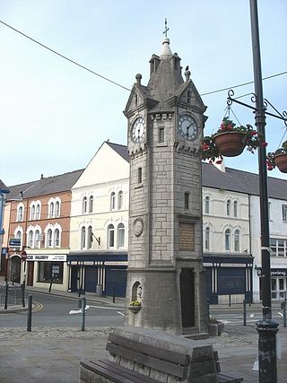
Llangefni is the county town of Anglesey in Wales and contains the principal offices of the Isle of Anglesey County Council. United Kingdom Census 2011 recorded Llangefni's population as 5,116 people, making it the second largest settlement in the county. The community includes the village of Rhosmeirch.

Amlwch is a port town and community in Wales. It is situated on the north coast of the Isle of Anglesey, on the A5025 which connects it to Holyhead and to Menai Bridge. As well as Amlwch town and Amlwch Port, other settlements within the community include Burwen, Porthllethog/Bull Bay and Pentrefelin. The town has a beach in Llaneilian, and it has significant coastal cliffs. Tourism is an important element of the local economy. At one time it was a booming mining town that became the centre of a vast global trade in copper ore. The harbour inlet became a busy port and significant shipbuilding and ship repair centre, as well as an embarkation point with boats sailing to the Isle of Man and to Liverpool. The community covers an area of about 18 square kilometres.

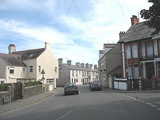
Rhosneigr is a village in the south-west of Anglesey, north Wales. It is situated on the A4080 road some 10 km south-east of Holyhead, and is on the Anglesey Coastal Path. From the clock at the centre of the village can be seen RAF Valley and Mynydd Twr. The major towns of Holyhead and Llangefni and the city of Bangor are all within easy travelling distance. It is the most expensive place to live in Anglesey in terms of house prices.

The Isle of Anglesey County Council is the local authority for the county of Anglesey, one of the principal areas of Wales. Since 2022 the council has 35 councillors who represent 11 multi-member electoral wards.

Llanbadrig is a village and community in Anglesey, Wales. The parish includes the township of Clygyrog, Tregynrig and the port of Cemaes, and was formerly in the cwmwd of Talybolion. The area has extensive quarries of limestone and marble. At the 2001 census it had a population of 1,392, reducing slightly to 1,357 at the 2011 census.

Rhosyr is a community in the far southern corner of Anglesey, Wales. It includes the villages of Dwyran and Newborough, Llangeinwen and Llangaffo.

Cerrig Man is a village in Anglesey, in north-west Wales, in the community of Llaneilian and the electoral ward of Twrcelyn. It is located a mile north of Penysarn and a mile south of Amlwch.
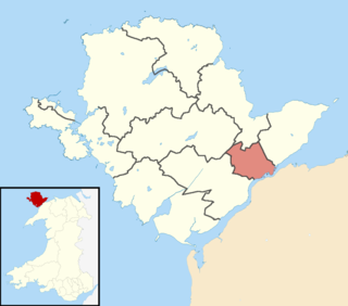
Kingsland is an area in the community of Holyhead, Anglesey, Wales.
Morawelon (Môrawelon) is an area and community electoral ward in the town of Holyhead, Anglesey, Wales.
The Isle of Anglesey electoral boundary changes in 2012 reduced the numbers of electoral wards to the Isle of Anglesey County Council from 40 to 11. This led to the postponement of local government elections in the county by 12 months. The changes were confirmed by the Isle of Anglesey Order 2012 in October 2012.
The 2008 Isle of Anglesey Council election took place on Thursday 1 May 2008 to elect members of the Isle of Anglesey County Council in Wales. This was the same day as other United Kingdom local elections. The previous full council election was on 10 June 2004 and the next full council election was held on 2 May 2013.

Caergybi is an electoral ward in Holyhead, Anglesey, Wales. It includes the northern half of the community including the town centre and port. Caergybi elects three county councillors to the Isle of Anglesey County Council. Caergybi includes the community wards of Town, London Road, Morawelon, Porthafelin and Parc a'r Mynydd, which elect representatives to Holyhead Town Council.
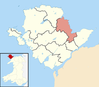
Lligwy is an electoral ward on the northeast coast of Anglesey, Wales. It includes the communities Moelfre, Llaneugrad, Llanfair-Mathafarn-Eithaf and Pentraeth; and the electoral ward of Llanfihangel Tre'r Beirdd in the community of Llanddyfnan. Lligwy elects three county councillors to the Isle of Anglesey County Council.

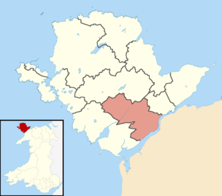
Canolbarth Môn is an electoral ward in the centre of Anglesey, Wales. It includes the communities of Bryngwran, Bodffordd, Llangefni, and Trewalchmai, and the majority of Llanddyfnan. Canolbarth Môn elects three county councillors to the Isle of Anglesey County Council.
Maeshyfryd is an area southwest of the port and town centre of Holyhead in Anglesey, Wales. It was formerly an electoral ward to the county council.

Bro Aberffraw is an electoral ward in the southern corner of Anglesey, Wales. It comprises the three communities of Aberffraw, Bodorgan and Rhosyr. Canolbarth Môn elects two county councillors to the Isle of Anglesey County Council.
The 2004 Isle of Anglesey County Council election took place on Thursday 10 June 2004 to elect members of the Isle of Anglesey County Council in Wales. This was the same day as other United Kingdom local elections. The next full council election was on 1 May 2008.
Bro Rhosyr is an electoral ward in the south of Anglesey, Wales, created in 2012.
Aethwy is the name of an electoral ward in the south of Anglesey, Wales, created in 2012. It contains the population centres of Menai Bridge and Llanfair PG.
Ynys Gybi is the name of an electoral ward in the west of Anglesey, Wales, created in 2012. It covers the most part of Holy Island, whose name is Ynys Gybi in Welsh.
