Tyburn was a manor (estate) in the county of Middlesex, England, one of two which were served by the parish of Marylebone. Tyburn took its name from the Tyburn Brook, a tributary of the River Westbourne. The name Tyburn, from Teo Bourne, means 'boundary stream'.

Paddington is an area in the City of Westminster, in central London, England. A medieval parish then a metropolitan borough, it was integrated with Westminster and Greater London in 1965. Paddington station, designed by the engineer Isambard Kingdom Brunel opened in 1847. It is also the site of St Mary's Hospital and the former Paddington Green Police Station.

The subterranean or underground rivers of London are or were the direct or indirect tributaries of the upper estuary of the Thames that were built over during the growth of the metropolis of London. They now flow through culverts, with some of them integral parts of London's sewerage system and diverted accordingly.

The River Rea is a small river which passes through Birmingham, England. It is the river on which Birmingham was founded by the Beorma tribe in the 7th century.

Erdington is a suburb and ward of Birmingham in the West Midlands County, England. Historically part of Warwickshire and located 5 miles (8 km) northeast of central Birmingham, bordering Sutton Coldfield. It was also a council constituency, managed by its own district committee. The former council district consisted of the ward of Erdington, and Tyburn,, Stockland Green and Kingstanding, although all of Kingstanding and most of both Tyburn and Stockland Green wards lie outside the historical boundaries of Erdington. Stockland Green was formerly part of Aston, Kingstanding part of Perry Barr and Tyburn partially split between Aston and Hodge Hill. Erdington (ward) was part of the Sutton Coldfield constituency before 1974.

The River Brent is a river in west and northwest London, England, and a tributary of the River Thames. 17.9 miles (28.8 km) in length, it rises in the Borough of Barnet and flows in a generally south-west direction before joining the Tideway stretch of the Thames at Brentford.

The Hogsmill River in Surrey and Greater London, England is a small chalk stream tributary of the River Thames. It rises in Ewell and flows into the Thames at Kingston upon Thames on the lowest non-tidal reach, that above Teddington Lock.

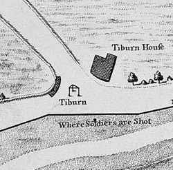
The River Tyburn was a stream in London, England. Its main successor sewers emulate its main courses, but it resembled the Colne in its county of Middlesex in that it had many distributaries. It ran from South Hampstead, through Marylebone, Mayfair, St James's parish/district and Green Park to meet the tidal Thames at four sites, grouped into pairs. These pairs were near Whitehall Stairs, and by Thorney Street, between Millbank Tower and Thames House. Its much smaller cousin, the Tyburn Brook, was a tributary of the Westbourne and the next Thames tributary.

The River Crane, a tributary of the River Thames, runs 8.5 miles (13.6 km) in West London, England. It forms the lower course of Yeading Brook. It adjoins or passes through three London boroughs: Hillingdon, Hounslow and Richmond upon Thames, in the historic county of Middlesex. The drainage basin is heavily urbanised but many of the Hayes to Whitton flood-meadows have been conserved, forming a narrow, green vale, opening out to what remains of Hounslow Heath in the centre – a near-continuous belt of semi-natural habitat.

Known as the Hagley Road in Birmingham, the A456 is a main road in England running between Central Birmingham and Woofferton, Shropshire, south of Ludlow. Some sections of the route, for example Edgbaston near Bearwood, are also the route of the Elan Aqueduct which carries Birmingham's water supply from the Elan Valley.

Forty Hill is a largely residential suburb in the north of the London Borough of Enfield, England. To the north is Bulls Cross, to the south Enfield Town, to the west Clay Hill, and to the east Enfield Highway. Prior to 1965 it was in the historic county of Middlesex.

The River Sence is a river which flows in Leicestershire, England. The tributaries of the Sence, including the Saint and Tweed, fan out over much of western Leicestershire from Charnwood Forest and Coalville in the north-east to Hinckley and almost to Watling Street in the south and south-west. Its watershed almost coincides with Hinckley and Bosworth Borough of Leicestershire, which was formed in 1974 by amalgamation of Market Bosworth Rural District and Hinckley Urban District. It flows into the Anker, which in turn flows into the River Tame. It is part of the wider River Trent catchment, which covers much of central England. In 1881, Sebastian Evans wrote that the usual names for this river were Shenton Brook and Sibson Brook.

Tin Brook is a 9-mile-long (14 km) tributary of the Wallkill River almost entirely located in the town of Montgomery in Orange County, New York, United States, where it drains 19.2 square miles (50 km2). Near its mouth it flows through the village of Walden. It is one of the few named tributaries of the Wallkill that drain into it from the lowlands between it and the Hudson River to the east, rather than the Shawangunk Ridge to the west.

Yeading Brook is the dominant source of the River Crane, in outer North West then West London. The western branch flows 25.8 km (16.0 mi) south. It rises in the far south of suburban Pinner and drains all of the western suburbs of Harrow, insofar as they have not been by historical practice connected into sewers.

Fringford is a village and civil parish in Oxfordshire, about 4 miles (6.4 km) northeast of Bicester. The parish is bounded to the east by the Roman road that linked Alchester Roman Town with Roman Towcester, to the south by a brook that joins the River Bure, to the north mostly by a brook that is a tributary of the River Great Ouse, and to the west by field boundaries. Fringford village is in the north of the parish, surrounded on two sides by a bend in the tributary of the Great Ouse.

Marylebone is a district in the West End of London, in the City of Westminster. Oxford Street forms its southern boundary.
Sandford St Martin is a village and civil parish in West Oxfordshire about 7 miles (11 km) east of Chipping Norton and about 12 miles (19 km) south of Banbury. The 2011 Census recorded the parish's population as 209.

Sudbrook and its tributary, the Latchmere stream, are north-flowing streams in London, England, that drain northern Kingston upon Thames and the eastern extreme of Ham following a meander scar in a terrace; the upper part of the Sudbrook drains a narrow vale in Richmond Park's southern corner into the tidal Thames.

Eia or Eye was an early Medieval manor in the parish of Westminster, Middlesex and is now a part of Central London. It was about one mile west of the Palace of Westminster/Whitehall, about 2 miles west-south-west of the walled City of London, and about half a mile north of the River Thames.