Related Research Articles

Woodend railway station is a regional railway station on the Deniliquin line, which is part of the Regional railway network. It serves the north-western suburb and town of Woodend, in Victoria, Australia. Woodend station is a ground level premium station, featuring two side platforms. It opened on 8 July 1861.

Kyneton railway station is a regional railway station on the Deniliquin line, which is part of the Regional railway network. It serves the north-western suburb and town of Kyneton, in Victoria, Australia. Kyneton station is a ground level unstaffed station, featuring two side platforms. It opened on 25 April 1862.

Kyneton is a town in the Macedon Ranges region of central Victoria, Australia. The Calder Freeway bypasses Kyneton to the north and east. Kyneton is on Dja Dja Wurrung and Taungurung country.
The Daylesford Spa Country Railway is a volunteer-operated 1,600 mm gauge tourist railway located in Victoria, Australia. It operates on a section of the closed and dismantled Daylesford line, and currently runs services between Daylesford and the hamlet of Bullarto.

Daylesford is a spa town located in the foothills of the Great Dividing Range, within the Shire of Hepburn, Victoria, Australia, approximately 114 kilometres north-west of Melbourne. First established in 1852 as a gold-mining town, today Daylesford has a population of 2,781 as of the 2021 census.
The Deniliquin railway line is a broad-gauge railway line serving north-western Victoria, Australia. The line runs from the New South Wales town of Deniliquin into Bendigo, before turning south-south-east towards Melbourne, terminating in Docklands near the central business district. It is a major trunk line both for passenger and freight trains, with many lines branching off from it.
Beveridge is a closed railway station on the North East railway that served the township of Beveridge, Victoria, Australia.
Carlsruhe railway station is a former railway station located in Carlsruhe, Victoria. The station is located on the Bendigo line and closed in 1982 as part of the New Deal for Country Passengers.

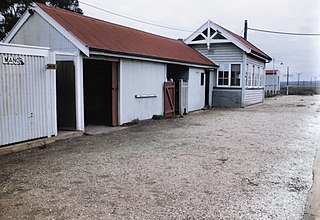
Taradale railway station was located was on the Bendigo line, 108 km (67 mi) from Southern Cross station, and served the township of Taradale.
Manor is a closed station which was located about halfway between Werribee and Little River stations on the Geelong railway line in Victoria, Australia.
Gordon is a closed railway station, located in the town of Gordon, on the Melbourne - Ballarat railway line in Victoria, Australia. In the 2010s, the station building was renovated by a group associated with the former Victorian division of the Australian Railway Historical Society.

The Shire of Kyneton was a local government area about 85 kilometres (53 mi) northwest of Melbourne, the state capital of Victoria, Australia. The shire covered an area of 725.2 square kilometres (280.0 sq mi), and existed from 1859 until 1995.

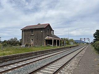
Moorabool is a closed railway station on the Geelong–Ballarat railway line, in the locality of Moorabool, Victoria, Australia. Until 1864 it was called Steiglitz Road. The station building was constructed for the Victorian Railways in 1861, by a private contractor, and comprises a single-storey, gable-roofed, bluestone station building, with an attached two-storey residence.
Musk railway station is in Musk, in central Victoria, Australia. It was opened in September 1881 under the name of Musk Creek, the name being shortened to Musk in 1905. The station closed with the line on Monday, 3 July 1978.
Bullarto railway station is a railway station on the Daylesford line, in Bullarto, Victoria, Australia. The station opened on Wednesday, 17 March 1880, and closed on Monday, 3 July 1978.

Trentham railway station is a closed railway station in the town of Trentham, Victoria, Australia, on the former Carlsruhe-to-Daylesford line. It opened on Monday, 16 February 1880, and was closed on Monday, 3 July 1978.
Fern Hill railway station on the Daylesford railway line in Victoria, Australia was opened on Monday, 16 February 1880, and closed on Monday, 3 July 1978.
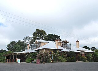
Lyonville is a town located in the Shire of Hepburn, Victoria, Australia. East of Daylesford on the Trentham road, the town takes its name from James Lyon who had arrived in the Glenlyon district in the 1860s. At the 2016 census, Lyonville had a population of 175.
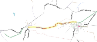
The Domino Trail is a shared used path running from Trentham, Victoria to Lyonville, 75km northwest of Melbourne. The trail mostly follows part of the route of the former Carlsruhe to Daylesford railway line — part of which is still running as the Daylesford Spa Country Railway —. The trail has been primarily developed for walkers, but is usable by mountain bikes.
Strangways is a locality split between the local government areas of Hepburn Shire and Mount Alexander Shire, in Central Victoria, Australia. It covers an area of 20.105 square kilometres between the townships of Guidford to the east, Newstead to the north-west and Clydesdale to the south.
References
37°20′13″S144°26′16″E / 37.33694°S 144.43778°E
| | This article about a railway station in Victoria (state) is a stub. You can help Wikipedia by expanding it. |