Tyldesley Town Hall

Last updated

Tyldesley Town Hall
Tyldesley Town Hall (geograph 2575649).jpg
Tyldesley Town Hall
LocationElliott Street, Tyldesley
Coordinates 53°30′50″N2°27′51″W / 53.5140°N 2.4643°W / 53.5140; -2.4643 Coordinates: 53°30′50″N2°27′51″W / 53.5140°N 2.4643°W / 53.5140; -2.4643
Built1881
Architectural style(s) Victorian style
Greater Manchester UK location map 2.svg
Red pog.svg
Shown in Greater Manchester

Tyldesley Town Hall is a municipal building in Elliott Street, Tyldesley, Greater Manchester, England. Initially the local Liberal Party Club, the town hall went on to become the meeting place of Tyldesley Urban District Council.

History

In the late 19th century both the main political parties decided to establish clubs for their members in the town: the site the Liberal Party selected was open land at the corner of Elliott Street and Well Street, [1] while the site the Conservative Party selected was open land on the corner of Shuttle Street and Stanley Street. [1] [2]

The Liberal Party building, which was designed in the Victorian style, was built in red brick and was officially opened by the local mill owner and future member of parliament, Caleb Wright, on 6 January 1881. [3] The design involved a symmetrical main frontage with three bays facing onto Elliott Street; the central bay featured a doorway on the ground floor, there were mullion windows on the first and second floors and on all floors in the other bays. There was a date stone, displaying the year 1880, in the middle of the front elevation at roof level. Internally, the principal room was the main assembly hall. [4]

Meanwhile, the local health board had established its offices in Lower Elliott Street, where it had also erected a fire station and a works depot; [5] however, civic leaders decided that they needed more substantial premises after the area became an urban district in 1894. [6] In line with the rise of the Labour Party and the decline of the Liberal Party across the country, local membership of the Liberal Club fell and the club got into financial difficulties. The local council decided to acquire the premises from the Liberal Club for £2,000 and converted it into a town hall in 1924. [3] The council also acquired a fine portrait of Sir Thomas Tyldesley, a Royalist commander who served during the English Civil War, and arranged for it to be installed inside the building. [7] King George VI and Queen Elizabeth drove past the waving crowds on the steps of the town hall on 18 May 1938. [8]

The building continued to serve as a meeting place for Tyldesley Urban District Council for much of the 20th century but ceased to be the local seat of government after the enlarged Wigan Metropolitan Borough Council was formed in 1974. [9] Since then, apart from being used as a venue for councillors' surgeries and as a closed-circuit television control centre for the town centre, the town hall remained vacant. [10]

Following an announcement by English Heritage in September 2019, that Wigan Council would receive funding to create a Heritage Action Zone in Tyldesley, [11] [12] Wigan Council announced, in November 2019, a programme of improvement works to the town hall costing £1.5 million. The proposed works were intended to enable Tyldesley Library to relocate from its current aging premises in Stanley Street into the town hall, [13] as well as to enable space to be created in the town hall for a café, a drop-in surgery and other facilities for community groups. [10] [14]

Related Research Articles

Leigh, Greater Manchester Town in the Metropolitan Borough of Wigan

Leigh is a town in the Metropolitan Borough of Wigan, Greater Manchester, England, on low-lying land northwest of Chat Moss.

Metropolitan Borough of Wigan Borough of Greater Manchester, England

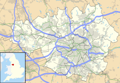
The Metropolitan Borough of Wigan is a metropolitan borough of Greater Manchester, in North West England. It is named after the main settlement of Wigan. It covers the towns of Atherton, Ashton-in-Makerfield, Golborne, Hindley, Ince-in-Makerfield, Leigh and Tyldesley. The borough also covers the villages and suburbs of Abram, Aspull, Astley, Bryn, Hindley Green, Lowton, Mosley Common, Orrell, Pemberton, Shevington, Standish, Winstanley and Worsley Mesnes.

Atherton, Greater Manchester Town within the Metropolitan Borough of Wigan, England

Atherton is a town in the Metropolitan Borough of Wigan, in Greater Manchester, England and historically a part of Lancashire. The town, including Hindsford, Howe Bridge and Hag Fold, is 5 miles (8.0 km) east of Wigan, 2 miles (3.2 km) north of Leigh, and 10+34 miles (17.3 km) northwest of Manchester. From the 17th century, for about 300 years, Atherton was known as Chowbent, which was frequently shortened to Bent, the town's old nickname.

Astley, Greater Manchester Human settlement in England

Astley is a village in the Metropolitan Borough of Wigan, Greater Manchester, England. Within the boundaries of the historic county of Lancashire, it is crossed by the Bridgewater Canal and the A580 East Lancashire Road. Continuous with Tyldesley, it is equidistant from Wigan and Manchester, both 8.3 miles (13.4 km) away. Astley Mosley Common ward had a population of 11,270 at the 2011 Census.

Tyldesley Human settlement in England

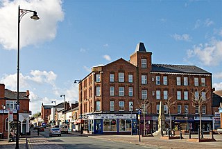
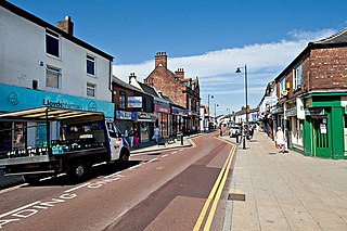
Tyldesley is a town in the Metropolitan Borough of Wigan in Greater Manchester, England. Within the boundaries of the historic county of Lancashire, it is north of Chat Moss near the foothills of the West Pennine Moors, 7.7 miles (12.4 km) southeast of Wigan and 8.9 miles (14.3 km) northwest of Manchester. At the United Kingdom Census 2001, the Tyldesley built-up area, excluding Shakerley, had a population of 16,142.

Wigan Town in Greater Manchester, England

Wigan is a large town in Greater Manchester, England, on the River Douglas. The town is midway between the two cities of Manchester, 16 miles (25.7 km) to the south east, and Liverpool, 17 miles (27 km) to the southwest. The towns of Bolton to the northeast, and Warrington to the south are 10 miles (16 km) and 12 miles (19 km) away respectively. Within the boundaries of the historic county of Lancashire, Wigan is the largest settlement in the Metropolitan Borough of Wigan and its administrative centre. The town has a population of 107,732 and the wider borough of 330,713.

Shakerley Human settlement in England

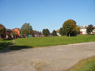
Shakerley is a suburb of Tyldesley in the Metropolitan Borough of Wigan, Greater Manchester, England. It was anciently a hamlet in the northwest of the township of Tyldesley cum Shakerley, in the ancient parish of Leigh. The boundary between Shakerley and Hindsford is the Hindsford Brook. It remains the boundary between Tyldesley and Atherton. Hyndforth Bridge across the brook, was rebuilt in stone in 1629.

St Georges Church, Tyldesley Church in Greater Manchester, England

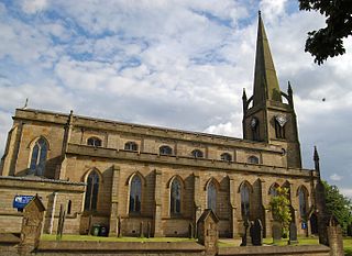
St George's Church is an Anglican parish church serving Tyldesley and Shakerley in Greater Manchester, England. It is part of Leigh deanery in the archdeaconry of Salford and the diocese of Manchester. The church, together with St Stephen's Church, Astley and St John's Church, Mosley Common is part of the united benefice of Astley, Tyldesley and Mosley Common.

Tyldesley Urban District

Tyldesley cum Shakerley Urban District and its successor Tyldesley Urban District was, from 1894 to 1974, a local government district in Lancashire, England.

The Astley and Tyldesley Collieries Company formed in 1900 owned coal mines on the Lancashire Coalfield south of the railway in Astley and Tyldesley, then in the historic county of Lancashire, England. The company became part of Manchester Collieries in 1929 and some of its collieries were nationalised in 1947.

Bedford, Greater Manchester One of three townships that merged to form Leigh, England

Bedford, a suburb of Leigh, Greater Manchester is one of three ancient townships, Bedford, Pennington and Westleigh, that merged in 1875 to form the town of Leigh. Historically, Bedford was in Lancashire.

Leigh Town Hall Municipal building in Leigh, Greater Manchester, England

Leigh Town Hall is a municipal building in Leigh, Greater Manchester, England. It stands in Civic Square at the junction with Market Street, facing Leigh parish church. It was built in 1907 and granted grade II listed building status in 1987.

James Burton was born in Clitheroe in 1784 and owned several cotton mills in Tyldesley and Hindsford in the middle of the 19th century.

Tyldesley is a town in the Metropolitan Borough of Wigan, in Greater Manchester, England. It contains several listed buildings designated by English Heritage and included in the National Heritage List for England. Most are listed at Grade II, the lowest of the three gradings given to listed buildings and is applied to "buildings of national importance and special interest".

Garrett Hall

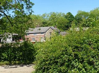
Garrett Hall or The Garrett is a former manor house and now a grade II listed farmhouse in Tyldesley, Greater Manchester, England. The hall was designated a grade II listed building in 1987.

Chaddock Hall was an ancient hall on Chaddock Lane in Tyldesley, Greater Manchester, England. It was designated a Grade II listed building in 1966. It was gutted in an arson attack in 2014.

This is an overview of Women's Suffrage activism and local politics as experienced in Leigh, Lancashire between 1900 and 1914.

Robert Isherwood was a miner's agent, local councillor and the first treasurer of the Lancashire and Cheshire Miners' Federation.

References

  1. 1 2 "Ordnance Survey Map". 1850. Retrieved 27 January 2021.
  2. "Old Tyldesley Conservative Club building set to be turned into 17 apartments to give site 'new lease of life'". Leigh Journal. 31 May 2018. Retrieved 27 January 2021.
  3. 1 2 Lunn, John (1953). "A Short History of the Township of Tyldesley". Tyldesley Urban District Council. p. 139.
  4. "Meeting of Liberals in the Tyldesley district". The Guardian. 9 April 1895. Retrieved 27 January 2021.
  5. Lunn, John (1953). "A Short History of the Township of Tyldesley". Tyldesley Urban District Council. p. 129.
  6. "Tyldesley UD". Vision of Britain. Retrieved 27 January 2021.
  7. "Remember Sir Thomas". Bolton News. 4 September 2001. Retrieved 27 January 2021.
  8. Turner, Hannah (1 April 2011). "The 1938 Royal Visit" (PDF). Past Forward. p. 5. Retrieved 27 January 2021.
  9. Local Government Act 1972. 1972 c.70. The Stationery Office Ltd. 1997. ISBN   0-10-547072-4.
  10. 1 2 "Plan to spend £1.5m bringing Tyldesley's town hall 'back to life' approved". Manchester Evening News. 25 November 2019. Retrieved 27 January 2021.
  11. "Tyldesley to receive boost through Heritage England fund". Leigh Journal. 16 September 2019. Retrieved 27 January 2021.
  12. "Multi-million-pound deal is great news for worst of Wigan's forgotten historic buildings". Wigan Today. 18 September 2019. Retrieved 27 January 2021.
  13. "Tyldesley Library to move into town hall after £1.5m refurbishment plans approved". Leigh Journal. 22 November 2019. Retrieved 27 January 2021.
  14. "Investment pledged to restore historic Tyldesley building". About Manchester. 25 November 2019. Retrieved 27 January 2021.