Tyne Stop Line defensive plan
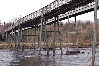
As soon as an invasion was confirmed, members of the 280th Field Company, Royal Engineers (based in Yorkshire), would rapidly advance north via Durham, Leadgate, Ebchester and Hexham and blow up more than 100 road, rail and foot bridges on the Tyne from the Rede Valley to Scotswood. The holes for the charges were already drilled (and the traces of many can still be seen to this day). Road approaches were to be mined and blocked by craters. The major bridges at Newcastle were to be mined but not blown up until the last minute; this was to enable any withdrawal of British forces southwards. One exception was the Swing Bridge, which was to be disabled.
Militarily Tyneside itself would be divided into eighteen districts, each with its own detailed plan of action. Beaufront Castle, between Hexham and Corbridge, was designated as the regional HQ. Industrialists met with the Regional Commissioner and the Military to arrange a scorched earth plan for Tyneside's major industries. Each was given a code word and, on receipt of their particular word, all machinery in their premises would be disabled by removing essential parts. Other signals, such as the ringing of church bells, would activate other plans: makeshift road blocks would appear all over Tyneside, in Newcastle itself at the West Road, Nuns Moor Road, Fenham Hall Drive, Shields Road, Walker Road, Heaton Road and Chillingham Road, for example; electricity would be cut by exploding charges at nodal points on the network; L.N.E.R. locomotives would disappear along country lines south of the Tyne (such as the Victoria Garesfield branch line) and then be disabled; on the Tyne and along the coast docks would be blocked and machinery disabled; fuel stores would be destroyed; the ferry landings at North and South Shields would be blown up and the ferries scuttled; and all major explosive and ammunition dumps would have their stocks either blown up or otherwise destroyed.
A network of local HQs and supply stores were set up at locations such as Manors Railway Station, the Royal Grammar School and the Newcastle Co-op premises on Newgate Street.
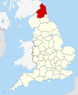
Northumberland is a historic county, ceremonial county and unitary authority in Northern England. The latter has a headquarters at Morpeth and borders east Cumbria, north County Durham and north Tyne and Wear. The historic county town is Alnwick. It and the historic county of Durham are traditionally known together as Northumbria.

Newcastle upon Tyne, often simply Newcastle, is the most populous city and metropolitan borough in North East England. It forms the core of the Tyneside conurbation, the eighth most populous urban area in the United Kingdom. The city is situated on the River Tyne's northern bank, approximately 8.5 mi (13.7 km) from the North Sea.

Tyne and Wear is a metropolitan county in North East England, situated around the mouths of the rivers Tyne and Wear. It came into existence in 1974 after the passage of the Local Government Act 1972. It consists of the five metropolitan boroughs of Newcastle upon Tyne, Gateshead, North Tyneside, South Tyneside and the City of Sunderland. The county is bordered to the north by Northumberland, to the south by County Durham and to the east of the county lies the North Sea. It is the smallest county in North East England by area, but by far the largest in terms of population.

The Metropolitan Borough of North Tyneside is a metropolitan borough in the metropolitan county of Tyne and Wear, North East England. It forms a part of the greater Tyneside conurbation. The North Tyneside Council is headquartered at Cobalt Business Park, Wallsend.

Corbridge is a village in Northumberland, England, 16 miles (26 km) west of Newcastle and 4 miles (6 km) east of Hexham. Villages nearby include Halton, Acomb, Aydon and Sandhoe.

Hexham is a market town and civil parish in Northumberland, England, on the south bank of the River Tyne, formed by the confluence of the North Tyne and the South Tyne at Warden Rock nearby, and close to Hadrian's Wall. Hexham was the administrative centre for the Tynedale district from 1974 to 2009. In 2011, it had a population of 13,097.

Newcastle Central Station is a major railway station in Newcastle upon Tyne. It is located on the East Coast Main Line, around 268 miles (432 km) north of London King's Cross.

The history of Newcastle upon Tyne dates back almost 2,000 years, during which it has been controlled by the Romans, the Angles and the Norsemen amongst others. Originally known by its Roman name Pons Aelius, the name "Newcastle" has been used since the Norman conquest of England. Due to its prime location on the River Tyne, the town developed greatly during the Middle Ages and it was to play a major role in the Industrial Revolution, being granted city status in 1882. Today, the city is a major retail, commercial and cultural centre.
Ovingham is a civil parish and village in the Tyne Valley of south Northumberland, England. It lies on the River Tyne 10 miles (16 km) east of Hexham with neighbours Prudhoe, Ovington, Wylam and Stocksfield.

Riding Mill is a village near Hexham in Northumberland, England. It is part of the civil parish of Broomhaugh and Riding. It is served by Riding Mill railway station and by a frequent bus service on the route from Hexham to Newcastle.

Northumberland Park is a Tyne and Wear Metro station, serving the village of Backworth and suburbs of Northumberland Park and West Allotment, North Tyneside in Tyne and Wear, England. It joined the network on 11 December 2005.
The Blyth and Tyne Railway was a railway company in Northumberland, England. It was incorporated in 1853 to unify several private railways and waggonways that were concerned with bringing coal from the Northumberland coalfield to Blyth and to the River Tyne. Over the years, it expanded its network to include Ashington, Morpeth and Tynemouth. As coal output increased, the company became very prosperous in hauling the mineral to quays for export and, in addition, a residential passenger service based on Newcastle built up.

The Northumberland Football Association is a governing body in the historic county of Northumberland, England. The association was formed in 1883. It is responsible for the governance and development of football at all levels in the county.
The Border Counties Railway was a railway line connecting Hexham in Northumberland, with Riccarton Junction on the Waverley Route in Roxburghshire.

Newcastle City Centre is the city centre district of Newcastle upon Tyne, England. It is the historical heart of the city and serves as the main cultural and commercial centre of the North East England region. Along with nearby Gateshead town centre, which lies on the opposite side of the River Tyne, the city centre forms the core of the Tyneside conurbation.

Tyne and Wear is a metropolitan area covering the cities of Newcastle upon Tyne and Sunderland, as well as North and South Tyneside, Gateshead and Washington.

The Tyne Valley Line is a 58-mile (93 km) route, linking Newcastle upon Tyne with Hexham and Carlisle. The line follows the course of the River Tyne through Tyne and Wear and Northumberland. Five stations and two viaducts on the route are listed structures.
The Hexham and Allendale Railway was a railway company formed in 1865 to build a branch line from the lead mining district of Allendale in Northumberland to a junction near Hexham on the Carlisle to Newcastle line. It opened to goods and mineral traffic in two stages from 1867, and to passengers in 1869.

The Newcastle & Carlisle Railway (N&CR) was an English railway company formed in 1825 that built a line from Newcastle upon Tyne on Britain's east coast, to Carlisle, on the west coast. The railway began operating mineral trains in 1834 between Blaydon and Hexham, and passengers were carried for the first time the following year. The rest of the line opened in stages, completing a through route between Carlisle and Gateshead, south of the River Tyne in 1837. The directors repeatedly changed their intentions for the route at the eastern end of the line, but finally a line was opened from Scotswood to a Newcastle terminal in 1839. That line was extended twice, reaching Newcastle Central station in 1851.
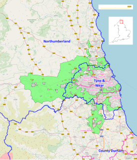
The North East Green Belt, also known as the Tyne & Wear Green Belt, is a non-statutory green belt environmental and planning policy that regulates the rural space in part of the North East region of England. It is centred on the county of Tyne and Wear, with areas of belt extending into Northumberland and County Durham. The belt functions to protect surrounding towns and villages outside the Tyneside/Newcastle-upon-Tyne and Wearside/Sunderland conurbations from further convergence. It is managed by local planning authorities on guidance from central government.