Northumberland National Park is the northernmost national park in England. It covers an area of more than 1,050 square kilometres (410 sq mi) between the Scottish border in the north to just south of Hadrian's Wall, and it is one of least visited of the National Parks. The park lies entirely within Northumberland, covering about a quarter of the county.

Kielder Forest is a large forestry plantation in Northumberland, England, surrounding Kielder village and the Kielder Water reservoir. It is the largest man-made woodland in England with three-quarters of its 250 square miles (650 km2) covered by forest. The majority of the forest lies within Kielder Water and Forest Park, with the southern tip known as Wark Forest lying within Northumberland National Park. The forest is next to the England - Scotland border.
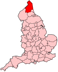
Northumberland, England's northernmost county, is a land where Roman occupiers once guarded a walled frontier, Anglian invaders fought with Celtic natives, and Norman lords built castles to suppress rebellion and defend a contested border with Scotland. The present-day county is a vestige of an independent kingdom that once stretched from Edinburgh to the Humber, hence its name, meaning literally 'north of the Humber'. Reflecting its tumultuous past, Northumberland has more castles than any other county in England, and the greatest number of recognised battle sites. Once an economically important region that supplied much of the coal that powered the industrial revolution, Northumberland is now a primarily rural county with a small and gradually shrinking population.

Sir James Douglas, 2nd Earl of Douglas and Mar was an influential and powerful magnate in the Kingdom of Scotland.

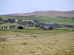
Otterburn is a small village in Northumberland, England, 31 miles (50 km) northwest of Newcastle upon Tyne on the banks of the River Rede, near the confluence of the Otter Burn, from which the village derives its name. It lies within the Cheviot Hills about 16 miles (26 km) from the Scottish border. The parish of Otterburn is at the heart of Redesdale, a Northumbrian upland valley.
Carter Bar is a pass in the Cheviot Hills, on the Anglo-Scottish border. It lies east of Carter Fell at the head of Redesdale, and is crossed by the A68 road as it runs north towards Teviotdale.

Elsdon is a village and civil parish in the English county of Northumberland about 10 miles (16 km) to the southwest of Rothbury. The name is derived from the Old English meaning Elli's valley.

The Rede is a river in Northumberland, England. The river rises on Carter Fell on the Anglo-Scottish border feeding Catcleugh Reservoir and joins the River North Tyne below the village of Redesmouth. The Rede is one of only two rivers in the North East of England that has the freshwater pearl mussel in its waters.

The Anglo-Scottish border is a border separating Scotland and England which runs for 96 miles (154 km) between Marshall Meadows Bay on the east coast and the Solway Firth in the west.
Clan Hall is a clan of Norman descent. The clan has no position under Scots law as contrary to modern myth they were not Scots, nor considered themselves as such, and have no chief recognised by the Court of the Lord Lyon.

Rochester is a small village and civil parish in north Northumberland, England. It is 5 miles (8 km) north-west of Otterburn on the A68 road between Corbridge and Jedburgh. The village is the site of the Roman fort of Bremenium, built there to protect the important Roman road of Dere Street, which passes through the village.
Reed may be either a surname or given name.

The Cheviot Hills, or sometimes The Cheviots, are a range of uplands straddling the Anglo-Scottish border between Northumberland and the Scottish Borders. The English section is within the Northumberland National Park. The range includes The Cheviot, plus Hedgehope Hill to the east, Windy Gyle to the west, and Cushat Law and Bloodybush Edge to the south.
Otterburn Tower is a Grade II listed castellated, three star country house hotel in Otterburn, Northumberland. It is set in 32 acres (13 ha) of deer park and woodland in the Northumberland National Park in northeastern England. Founded by a cousin of William the Conqueror in 1086, it was later owned by the Clan Hall, before being rebuilt in 1830 by Thomas James, a magistrate, on the site and using some of the stones from the Otterburn Castle. Nearby Otterburn Hall was built in 1870 on land given to a Lord Douglas as recompense for the death of his ancestor James Douglas, 2nd Earl of Douglas in the Battle of Otterburn.

Otterburn Hall is an English country house and estate in Otterburn, Northumberland. It is situated in 500 acres (200 ha) of deer park and woodland in the Northumberland National Park, northeastern England. The building was constructed in 1870 for Lord James Douglas, the land given to him as recompense for the death of Lord James Douglas, who fought at the Battle of Otterburn, and was killed near Otterburn Tower, itself founded in 1086, and rebuilt in 1830. Both Otterburn Hall and Otterburn Castle have been seats of landed gentry.

St Cuthbert's Church is located in Elsdon, Alnwick, northeast England. The church was one of the resting places of St. Cuthbert's body in the wanderings of the monks. It is one of the many dedicated to his memory. St Cuthbert's Church is a Grade I listed building in Northumberland.

The Percy Cross is located just off the A696, 1 kilometre (0.62 mi) from Otterburn, Northumberland, England. It was erected before 1400 to commemorate the Battle of Otterburn, which took place in 1388, and takes its name from Henry Percy, 1st Earl of Northumberland whose two sons took part in the battle. The memorial was restored and re-erected in 1777, and again in modern day, to include signage. The Percy Cross is a sandstone memorial which includes a square stepped base, approximately 1 metre in height and 2 metres in diameter.

Sir Robert de Umfraville KG, Lord of Redesdale was a knight in late-medieval England who took part in the later stages of the Hundred Years' War, particularly against Scotland. The de Umfraville family had been influential in northeast England for centuries and also held major estates in Yorkshire. His ancestors were mormaers of Angus, and his nephew married into the Percies, a powerful local marcher family with whom de Umfraville was closely associated. Much of Sir Robert's career continued on the same path as his ancestors, being primarily focused on defending the border with Scotland, which had been in a state of near-permanent warfare since the late thirteenth century.
The geology of Northumberland National Park in northeast England includes a mix of sedimentary, intrusive and extrusive igneous rocks from the Palaeozoic and Cenozoic eras. Devonian age volcanic rocks and a granite pluton form the Cheviot massif. The geology of the rest of the national park is characterised largely by a thick sequence of sedimentary rocks of Carboniferous age. These are intruded by Permian dykes and sills, of which the Whin Sill makes a significant impact in the south of the park. Further dykes were intruded during the Palaeogene period. The whole is overlain by unconsolidated sediments from the last ice age and the post-glacial period.