The Taunton Stop Line was a World War II defensive line in southwest England. It was designed "to stop an enemy's advance from the west and in particular a rapid advance supported by armoured fighting vehicles which may have broken through the forward defences."

The GHQ Line was a defence line built in the United Kingdom during World War II to contain an expected German invasion.

Amble is a town on the North Sea coast of Northumberland, England, at the mouth of the River Coquet; Coquet Island is visible from its beaches and harbour. In 2011, the parish of Amble by the Sea had a population of 6,025.

The River Coquet runs through the county of Northumberland, England, discharging into the North Sea on the east coast at Amble. It rises in the Cheviot Hills on the border between England and Scotland, and follows a winding course across the landscape ("Coquetdale"). The upper reaches are bordered by the Otterburn Ranges military training ground, and are crossed by a number of bridges built in the 20th century. It passes a number of small villages and hamlets, and feeds one of the lakes created by extraction of gravel that form the Caistron Nature Reserve, before reaching the town of Rothbury, where it is crossed by a grade II listed bridge. Below the town is Thrum Mill, a Grade II-listed water mill.

Warkworth is a village in Northumberland, England. It is probably best known for its well-preserved medieval castle, church and hermitage. The population of Warkworth was 1,493 in 2001, increasing to 1,574 at the 2011 Census.
The Outer London Defence Ring was a defensive ring built around London during the early part of the Second World War. It was intended as a defence against a German invasion, and was part of a national network of similar "Stop Lines".

Guyzance, historically Guizance, is a small village or hamlet and former civil parish, now in the parish of Acklington, in Northumberland, England. It is located on the River Coquet, roughly 6 miles south of Alnwick and around 3 miles west of Amble. Guyzance is one of only two places in Great Britain with a -zance ending; the other is Penzance in Cornwall. The similar names are co-incidence, however. In 1951 the parish had a population of 128.

Acklington is a small village in Northumberland, England. It is situated to the south-west of Amble, inland from the North Sea coast. It is served by Acklington railway station. The name is Anglo-Saxon Old English meaning 'farmstead of Eadlac's people'.
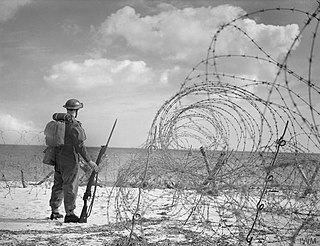
British anti-invasion preparations of the Second World War entailed a large-scale division of military and civilian mobilisation in response to the threat of invasion by German armed forces in 1940 and 1941. The British Army needed to recover from the defeat of the British Expeditionary Force in France, and 1.5 million men were enrolled as part-time soldiers in the Home Guard. The rapid construction of field fortifications transformed much of the United Kingdom, especially southern England, into a prepared battlefield. Sea Lion was never taken beyond the preliminary assembly of forces. Today, little remains of Britain's anti-invasion preparations, although reinforced concrete structures such as pillboxes and anti-tank cubes can still be commonly found, particularly in the coastal counties.

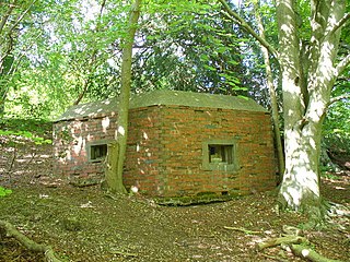
British hardened field defences of World War II were small fortified structures constructed as a part of British anti-invasion preparations. They were popularly known as pillboxes, a reference to their shape.
The Ringwood West Line was a World War II defensive line in England, running south from the GHQ Line near Frome to the coast.

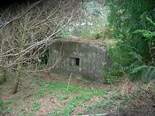
Hepple is a small village and parish in rural Northumberland, 4 miles (6.4 km) west of Rothbury, which provides most of its local services. It is on the edge of the Northumberland National Park, and lies on the bank of the river Coquet, at a location which was on the Coquet Stop Line, of which a pillbox remains. It is on the road between Rothbury and Otterburn. The village contains a church, village hall and post office.
The York, Newcastle and Berwick Railway (YN&BR) was an English railway company formed in 1847 by the amalgamation of the York and Newcastle Railway as well as the Newcastle and Berwick Railway. Both companies were part of the group of business interests controlled by George Hudson, the so-called Railway King. In collaboration with the York and North Midland Railway and other lines he controlled, he planned that the YN&BR would form the major part of a continuous railway between London and Edinburgh. At this stage the London terminal was Euston Square and the route was through Normanton. This was the genesis of the East Coast Main Line, but much remained to be done before the present-day route was formed, and the London terminus was altered to King's Cross.

The Ruck machine gun post or Ruck pillbox is a type of hardened field fortification built in Britain during the invasion crisis of 1940–1941. It was designed by James Ruck and was made from prefabricated concrete sections and paving slabs, sandbags and rammed earth. The Ruck machine gun post was relatively widely used in Lincolnshire and along the east coast of England, but is now extremely rare with just a handful of extant examples. Today, just five Ruck machine gun post sites are recorded in the Defence of Britain database.

The Norcon pillbox is a type of hardened field fortification built in Britain during the invasion crisis of 1940–1941. It was a small circular pillbox named after the company that manufactured it as a private commercial venture.

Warkworth Castle is a ruined medieval castle in Warkworth in the English county of Northumberland. The village and castle occupy a loop of the River Coquet, less than a mile from England's north-east coast. When the castle was founded is uncertain: traditionally its construction has been ascribed to Prince Henry of Scotland, Earl of Northumbria, in the mid-12th century, but it may have been built by King Henry II of England when he took control of England's northern counties. Warkworth Castle was first documented in a charter of 1157–1164 when Henry II granted it to Roger fitz Richard. The timber castle was considered "feeble", and was left undefended when the Scots invaded in 1173.

A pillbox is a type of blockhouse, or concrete dug-in guard-post, often camouflaged, normally equipped with loopholes through which defenders can fire weapons. It is in effect a trench firing step, hardened to protect against small-arms fire and grenades, and raised to improve the field of fire.
The Tyne Stop Line, which ran from the Rede Valley in Northumberland to Newcastle upon Tyne, formed part of the defences constructed to meet the threat of a Nazi invasion during World War II. Part of a network of such features, the Tyne Stop Line formed what would have been the principal defensive front for North East England against any attack coming from the north.

A Pickett-Hamilton fort is a type of hardened field fortification built in Britain during the invasion crisis of 1940–1941. The Pickett-Hamilton fort was designed to be lowered into the ground while it was not in use, to become inconspicuous and not interfere with the passage of taxiing aircraft or other vehicles. The fort could be raised to about 2 feet 6 inches (0.76 m) above ground level where it would be a physical impediment to aircraft and vehicles and from where a small crew could fire with rifles or light machine guns.