Somerset is a ceremonial county in South West England which borders Gloucestershire and Bristol to the north, Wiltshire to the east, Dorset to the south-east and Devon to the south-west. It is bounded to the north and west by the Severn Estuary and the Bristol Channel, its coastline facing southeastern Wales. Its traditional border with Gloucestershire is the River Avon.
Axminster is a market town and civil parish on the eastern border of the county of Devon in England. It is 28 miles (45 km) from the county town of Exeter. The town is built on a hill overlooking the River Axe which heads towards the English Channel at Axmouth, and is in the East Devon local government district. At the 2001 census, it had a population of 5,626, increasing to 5,761 at the 2011 census. The town contains two electoral wards the total sum of both wards being a population of 7,110. The market is still held every Thursday.

The Bridgwater and Taunton Canal is a canal in the south-west of England between Bridgwater and Taunton, opened in 1827 and linking the River Tone to the River Parrett. There were a number of abortive schemes to link the Bristol Channel to the English Channel by waterway in the 18th and early 19th centuries. These schemes followed the approximate route eventually taken by the Bridgwater and Taunton Canal, but the canal was instead built as part of a plan to link Bristol to Taunton by waterway.

The GHQ Line was a defence line built in the United Kingdom during World War II to contain an expected German invasion.
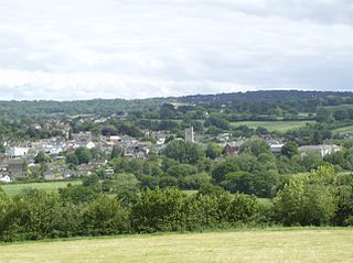
Chard is a town and a civil parish in the English county of Somerset. It lies on the A30 road near the Devon and Dorset borders, 15 miles (24 km) south west of Yeovil. The parish has a population of approximately 13,000 and, at an elevation of 121 metres (397 ft), Chard is the southernmost and one of the highest towns in Somerset. Administratively Chard forms part of the district of South Somerset.
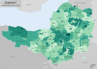
Somerset is a historic county in the south west of England. There is evidence of human occupation since prehistoric times with hand axes and flint points from the Palaeolithic and Mesolithic eras, and a range of burial mounds, hill forts and other artefacts dating from the Neolithic, Bronze and Iron Ages. The oldest dated human road work in Great Britain is the Sweet Track, constructed across the Somerset Levels with wooden planks in the 39th century BCE.

Creech St Michael is a village and civil parish in Somerset, three miles east of Taunton in the Somerset West and Taunton district. The parish straddles the M5 motorway and includes several scattered settlements. The village of Creech St Michael and the hamlets of Charlton, Creech Heathfield, and Ham lie east of the motorway. The hamlets of Adsborough, Coombe, Langaller, and Walford lie west of the motorway. The parish has a population of 2,416.
The Chard Canal was a 13.5 miles (21.7 km) tub boat canal in Somerset, England, that ran from the Bridgwater and Taunton Canal at Creech St. Michael, over four aqueducts, through three tunnels and four inclined planes to Chard. It was completed in 1842, was never commercially viable, and closed in 1868. The major engineering features are still clearly visible in the landscape.
Highbridge is a market town on the edge of the Somerset Levels near the mouth of the River Brue. It is in the County of Somerset, and is about 20 miles (32 km) northeast of Taunton, the county town of Somerset. No longer a market town, the market site is now a housing estate. Highbridge is in the District of Sedgemoor, being about 7 miles (11 km) north of Bridgwater, the district's administrative centre. Highbridge closely neighbours Burnham-on-Sea, forming part of the combined parish of Burnham-on-Sea and Highbridge and shares a town council with the resort town. The 2001 Census recorded Highbridge's population as 5,986. In the 2011 Census the population of the town was included in the ward of Highbridge and Burnham Marine, which totalled 7,555.
The Outer London Defence Ring was a defensive ring built around London during the early part of the Second World War. It was intended as a defence against a German invasion, and was part of a national network of similar "Stop Lines".
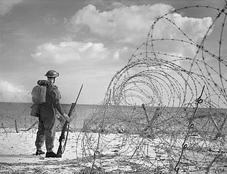
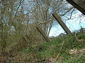
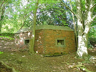
British anti-invasion preparations of the Second World War entailed a large-scale division of military and civilian mobilisation in response to the threat of invasion by German armed forces in 1940 and 1941. The British Army needed to recover from the defeat of the British Expeditionary Force in France, and 1.5 million men were enrolled as part-time soldiers in the Home Guard. The rapid construction of field fortifications transformed much of the United Kingdom, especially southern England, into a prepared battlefield. Sea Lion was never taken beyond the preliminary assembly of forces. Today, little remains of Britain's anti-invasion preparations, although reinforced concrete structures such as pillboxes and anti-tank cubes can still be commonly found, particularly in the coastal counties.

The Bristol and Exeter Railway (B&ER) was an English railway company formed to connect Bristol and Exeter. It was built on the broad gauge and its engineer was Isambard Kingdom Brunel. It opened in stages between 1841 and 1844. It was allied with the Great Western Railway (GWR), which built its main line between London and Bristol, and in time formed part of a through route between London and Cornwall.

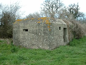
British hardened field defences of World War II were small fortified structures constructed as a part of British anti-invasion preparations. They were popularly known as pillboxes, a reference to their shape.

The Coquet Stop Line, which ran from Amble in Northumberland up the valley of the River Coquet, formed part of the defences constructed to meet the threat of a Nazi invasion during the Second World War. It was intended to slow the advance of the German army from the north to give time for a field army to assemble on the Tyne Stop Line around 30 miles to the south.

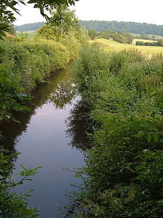
The Wellow Brook is a small river in Somerset, England.

The fortifications of London are extensive and mostly well maintained, though many of the City of London's fortifications and defences were dismantled in the 17th and 18th century. Many of those that remain are tourist attractions, most notably the Tower of London.
The Ringwood West Line was a World War II defensive line in England, running south from the GHQ Line near Frome to the coast.

The Chard branch lines were two lines serving the town of Chard in Somerset, England. One was a northward branch, opened in 1863, from the Salisbury to Exeter main line, and the other, opened in 1866, ran south-eastwards from the Bristol – Taunton main line. Each branch had its own Chard passenger station at first, although the two lines connected in Chard.

The earliest known infrastructure for transport in Somerset is a series of wooden trackways laid across the Somerset Levels, an area of low-lying marshy ground. To the west of this district lies the Bristol Channel, while the other boundaries of the county of Somerset are along chains of hills that were once exploited for their mineral deposits. These natural features have all influenced the evolution of the transport network. Roads and railways either followed the hills, or needed causeways to cross the Levels. Harbours were developed, rivers improved, and linked to sources of traffic by canals. Railways were constructed throughout the area, influenced by the needs of the city of Bristol, which lies just to the north of Somerset, and to link the ports of the far south-west with the rest of England.

The Bristol to Exeter line is a major branch of the Great Western Main Line in the West of England and runs from Bristol, to Exeter, from where it continues as the Exeter to Plymouth line. It was one of the principal routes of the pre-1948 Great Western Railway which were subsequently taken over by the Western Region of British Railways and are now part of the Network Rail system.