Uaxactun Airport | |||||||||||
|---|---|---|---|---|---|---|---|---|---|---|---|
| Summary | |||||||||||
| Serves | Uaxactun, Guatemala | ||||||||||
| Elevation AMSL | 573 ft / 175 m | ||||||||||
| Coordinates | 17°23′35″N89°38′05″W / 17.39306°N 89.63472°W Coordinates: 17°23′35″N89°38′05″W / 17.39306°N 89.63472°W | ||||||||||
| Map | |||||||||||
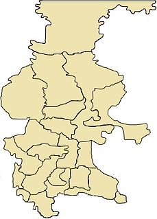
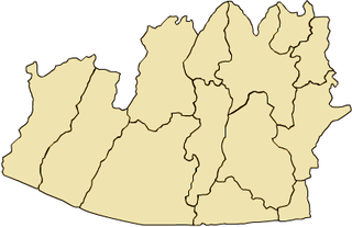
 UAX Location in Petén Department  UAX Location in Guatemala | |||||||||||
| Runways | |||||||||||
| |||||||||||
Uaxactun Airport( IATA : UAX) is an airstrip in the village of Uaxactun, Guatemala.
An IATA airport code, also known as an IATA location identifier, IATA station code or simply a location identifier, is a three-letter code designating many airports around the world, defined by the International Air Transport Association (IATA). The characters prominently displayed on baggage tags attached at airport check-in desks are an example of a way these codes are used.

Uaxactun is an ancient sacred place of the Maya civilization, located in the Petén Basin region of the Maya lowlands, in the present-day department of Petén, Guatemala. The site lies some 12 miles (19 km) north of the major center of Tikal. The name is sometimes spelled as Waxaktun.
Guatemala, officially the Republic of Guatemala, is a country in Central America bordered by Mexico to the north and west, Belize and the Caribbean to the northeast, Honduras to the east, El Salvador to the southeast and the Pacific Ocean to the south. With an estimated population of around 16.6 million, it is the most populated country in Central America. Guatemala is a representative democracy; its capital and largest city is Nueva Guatemala de la Asunción, also known as Guatemala City.
The airstrip may be closed. Aerial imagery (Google Earth 3/27/2014) shows less than 300 metres (980 ft) of grass landing area remaining unobstructed by trees and structures. [3] [4]
The Tikal VOR-DME (Ident: TIK) is located 31.8 nautical miles (58.9 km) south-southwest of Uaxactun. [5]