Related Research Articles
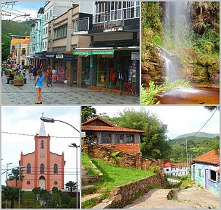
Lima Duarte is a municipality in the state of Minas Gerais, Brazil. It has a population of 16,724 inhabitants (2020) and a total area of 848 square kilometres (327 sq mi) and lies at an elevation of 860 metres (2,822 ft) in the foothills of the Mantiqueira Mountains. It was given city status in 1881.

Tupaciguara is a Brazilian municipality located in the west of the state of Minas Gerais. Its population as of 2020 was 25,398 peoples living in a total area of 1,826 km2. The city belongs to the statistical mesoregion of Triângulo Mineiro and Alto Paranaíba and to the statistical microregion of Uberlândia. It became a municipality in 1911.

Córrego Danta is a town located in the state of Minas Gerais, Brazil.
Cajuri is a Brazilian municipality located in the state of Minas Gerais. The city belongs to the mesoregion of Zona da Mata and to the microregion of Viçosa. As of 2020, the estimated population was 3,974.
Paineiras is a municipality in the midwest of the Brazilian state of Minas Gerais. As of 2020, the population was 4,462 in a total area of 638 km². It became a municipality in 1962.

Joaíma is a Brazilian municipality located in the northeast of the state of Minas Gerais.
Prata is a Brazilian municipality located in the west of the state of Minas Gerais. Its population as of 2020 was 28,017, living in a total area of 4,856 km². The city belongs to the statistical mesoregion of Triângulo Mineiro and Alto Paranaíba and to the statistical microregion of Uberlândia. It became a municipality in 1873.

Botumirim is a Brazilian municipality located in the north of the state of Minas Gerais. In 2020 the population was 6,288 in a total area of 1,572 km2. The elevation is 948 meters. It became a municipality in 1962.

Cristália is a Brazilian municipality located in the north of the state of Minas Gerais. In 2020 the population was 5,982 in a total area of 841 km2. The elevation is 728 meters. It became a municipality in 1962.

Jequitaí is a Brazilian municipality located in the north of the state of Minas Gerais. In 2020 the population was 7,468 in a total area of 1,268 km2. It became a municipality in 1948.
São Romão is a Brazilian municipality located in the north of the state of Minas Gerais. In 2020 the population was 12,529 in a total area of 2,432 km². It became a municipality in 1943.

Riachinho is a Brazilian municipality located in the north of the state of Minas Gerais. In 2020 the population was 8,134 in a total area of 1,775 km². It became a municipality in 1992.
Campo Azul is a Brazilian municipality located in the north of the state of Minas Gerais. In 2020 the population was 3,824 in a total area of 506 km². It became a municipality in 1995.
Claro dos Poções is a Brazilian municipality located in the north of the state of Minas Gerais. In 2020 the population was 7,514 in a total area of 706 km². It became a municipality in 1962.

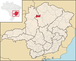
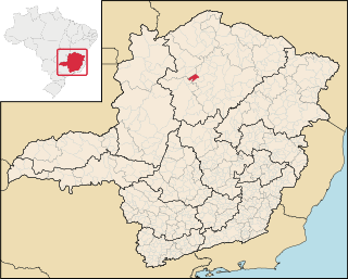
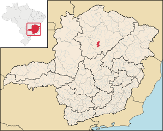
Carmo do Paranaíba is a Brazilian municipality located in the northwest of the state of Minas Gerais. Its population as of 2020 was 30,334 people living in a total area of 1,307 km2 (505 sq mi). The city belongs to the mesoregion of Triângulo Mineiro e Alto Paranaiba and to the microregion of Patos de Minas. It became a municipality in 1887.

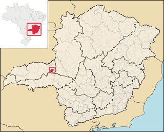
Cruzeiro da Fortaleza is a Brazilian municipality located in the northwest of the state of Minas Gerais. Its population as of 2020 was 3,639 people living in a total area of 185 km2. The city belongs to the mesoregion of Triângulo Mineiro e Alto Paranaiba and to the microregion of Patrocínio. It became a municipality in 1963.
Romaria is a Brazilian municipality located in the northwest of the state of Minas Gerais. Its population as of 2020 was 3,520 people living in a total area of 402 km². The city belongs to the mesoregion of Triângulo Mineiro e Alto Paranaiba and to the microregion of Patrocínio. It became a municipality in 1962.

Monte Alegre de Minas is a Brazilian municipality located in the west of the state of Minas Gerais. Its population as of 2020 was 21,236 living in a total area of 2,593 km2 (1,001 sq mi). The city belongs to the statistical mesoregion of Triângulo Mineiro and Alto Paranaíba and to the statistical microregion of Uberlândia. It became a municipality in 1870.

Senador Modestino Gonçalves is a Brazilian municipality in the state of Minas Gerais.

Fortaleza de Minas is a Brazilian municipality located in the southwest of the state of Minas Gerais. Its population as of 2020 was 4,437 people living in a total area of 218 km2 (84 sq mi). The city belongs to the meso-region of Sul e Sudoeste de Minas and to the micro-region of Passos. It became a municipality in 1963.
References
- Map from Ministry of Transport
- Rand McNally, The New International Atlas, 1993.
Coordinates: 18°35′52″S48°31′47″W / 18.59778°S 48.52972°W