
Rajasthan is a state in northern India. It covers 342,239 square kilometres (132,139 sq mi) or 10.4 per cent of India's total geographical area. It is the largest Indian state by area and the seventh largest by population. It is on India's northwestern side, where it comprises most of the wide and inhospitable Thar Desert and shares a border with the Pakistani provinces of Punjab to the northwest and Sindh to the west, along the Sutlej-Indus River valley. It is bordered by five other Indian states: Punjab to the north; Haryana and Uttar Pradesh to the northeast; Madhya Pradesh to the southeast; and Gujarat to the southwest. Its geographical location is 23°.3' to 30°.12' North latitude and 69°.30' to 78°.17' East longitude, with the Tropic of Cancer passing through its southernmost tip.
Kota or KOTA may refer to:
Kankroli is a twin City with Rajnagar, located in the district of Rajsamand in Rajasthan, India. It is located about 42 miles (68 km) north of Udaipur and forms a twin town with Rajsamand. Rajsamand is famous for Rajsamand lake built by Maharaja Raj Singh - I. Along the Rajsamand lake is the Kankroli town. It is known for its beautiful Dwarkadhish Ji Temple devoted to Lord Krishna.

Bhilwara is a city and administrative headquarters in Bhilwara district of the Mewar region of Rajasthan, India. It has been termed as 'Textile city'.

Banswara is a town in the Banswara district in southern Rajasthan, India. The name, Banswara, came from king ‘Bansiya Bhil’

Mewar or Mewad is a region in the south-central part of Rajasthan state of India. It includes the present-day districts of Bhilwara, Chittorgarh, Pratapgarh, Rajsamand, Udaipur, Pirawa Tehsil of Jhalawar District of Rajasthan, Neemuch and Mandsaur of Madhya Pradesh and some parts of Gujarat.

Chittorgarh is a major city in the state of Rajasthan in western India. It lies on the Berach River, a tributary of the Banas, and is the administrative headquarters of Chittorgarh District. It was a major stronghold of the Rajput State of Medapata. The city of Chittorgarh is located on the banks of river Gambhiri and Berach.
Vagad is a region in southeastern Rajasthan state of western India. Its boundaries are roughly defined by those of the districts of Dungarpur and Banswara. Major cities of the region are Dungarpur and Banswara.
Pratapgarh or Partabgarh may refer to the following places in India:

Udaipur district is one of the 50 districts of Rajasthan state in western India. The historic city of Udaipur is the administrative headquarters of the district. The district is part of the Mewar region of Rajasthan.
Gogunda is a town and tehsil headquarters of Gogunda Tehsil in Udaipur district, located about 35 km (22 mi) in north-west from Udaipur city in the Indian state of Rajasthan. It is situated on a high mountain in Aravalli hills and is reached by crossing a difficult mountain pass.
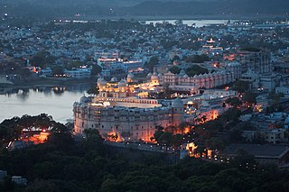
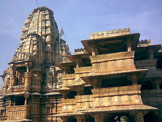
Udaipur is a city and municipal corporation in Udaipur district of the state of Rajasthan, India. It is also known as the 'City of Lakes' and serves as the administrative headquarters of Udaipur district. It is the historic capital of the kingdom of Mewar in the former Rajputana Agency. It was founded in 1559 by Udai Singh II of the Sisodia clan of Rajputs, when he shifted his capital from the city of Chittorgarh to Udaipur after Chittorgarh was besieged by Akbar. It remained as the capital city till 1818 when it became a British princely state, and thereafter the Mewar province became a part of Rajasthan when India gained independence in 1947.
Gomati, Gomti or Gomathi may refer to:
Kherwara Chhaoni is a census town in the Udaipur district in the Indian state of Rajasthan. It is part of the Vagad region, which includes the districts of Dungarpur, Banswara and parts of Udaipur district. It is in close proximity to two major highways, National Highway 8 and Rajasthan State Highway 76 and National Highway 927A passes through it. Its name derives from the large number of Kher (Khair) trees in the region in the past.
Singapore is an island city-state in Southeast Asia.
Peepal Khoont mainly known as Pipalkhunt is a village, Tehsil headquarter and Panchayat Samiti of the Pratapgarh district of Rajasthan state. It is a sub-division among the 5 sub-divisions of the Pratapgarh district. The main market is called Sadar Bajar. It is situated on National Highway 113. Pipalkhunt is a town located on the Banswara - Jaipur Expressway surrounded by the hills, plants and trees. The town is situated on the bank of the Mahi River.
Mewar is a region in Rajasthan, India.
Mavli Junction railway station is a railway station in Udaipur district, Rajasthan. Its code is MVJ. It serves Mavli town. The station consists of five platforms. Passenger Express and Superfast trains halt here.
Kapasan railway station is a railway station in Chittorgarh district, Rajasthan. Its code is KIN. It serves Kapasan city. The station consists of a single platform. Passenger, Express and Superfast trains halt here.
This page is based on this
Wikipedia article Text is available under the
CC BY-SA 4.0 license; additional terms may apply.
Images, videos and audio are available under their respective licenses.